
Uploaded by
shlomo
7 SLIDES
404 VUES
70LIKES
Maps of Continents and Countries
DESCRIPTION
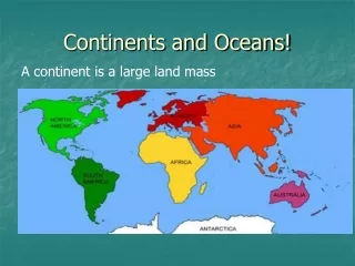
Maps of Continents and Countries. Which continent is shown on the map?. Europe. North America. Africa. South America. Which country is shown on the map?. Mexico. Canada. USA. Australia. Which country is shown on South America’s map?. Peru. Venezuela. Chile. Brazil.
Download
1 / 7
Télécharger la présentation 
Maps of Continents and Countries
An Image/Link below is provided (as is) to download presentation
Download Policy: Content on the Website is provided to you AS IS for your information and personal use and may not be sold / licensed / shared on other websites without getting consent from its author.
Content is provided to you AS IS for your information and personal use only.
Download presentation by click this link.
While downloading, if for some reason you are not able to download a presentation, the publisher may have deleted the file from their server.
During download, if you can't get a presentation, the file might be deleted by the publisher.
E N D
Presentation Transcript
Which continent is shown on the map? Europe North America Africa South America
Which country is shown on the map? Mexico Canada USA Australia
Which country is shown on South America’s map? Peru Venezuela Chile Brazil
Which country is shown on the map of Europe ? Norway Poland Spain Portugal
Which country is shown on the map of Europe ? France Germany Italy Greece
Which country is shown on the map of Asia ? Iran Japan Iraq India


More Related