U.S. Eastern Continental Shelf Carbon Budget: Modeling Insights
Explore the U.S. ECoS Program developing carbon budgets for Mid-Atlantic Bight and South Atlantic Bight. Analysis includes input sources, biological processes, food web pathways, climate change impact, and more. NASA-funded project with research questions on carbon cycle sensitivities. Utilizes biogeochemical and circulation models, satellite data analyses, and field measurements. Key scientists involved bring expertise in modeling, data assimilation, and analysis. Evaluation includes comparisons of simulated and in-situ data, with a focus on chlorophyll concentrations and CO2 flux. Continuous efforts to understand carbon and nutrient cycling processes in the region.

U.S. Eastern Continental Shelf Carbon Budget: Modeling Insights
E N D
Presentation Transcript
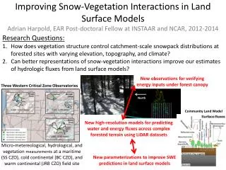
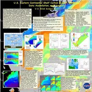
ABSTRACT. The U.S. Eastern Continental Shelf Carbon Budget (U.S. ECoS) Program, which began in summer 2004, is funded as part of the NASA Interdisciplinary Science Program. The overall goal of this project is to develop carbon budgets for the Mid-Atlantic Bight (MAB) and South Atlantic Bight (SAB) along the eastern U.S. coast. The U.S. ECoS program is structured around five themes which are focused on: 1) development and implementation of circulation, biogeochemistry, and carbon cycling models for the east coast of the U.S.; 2) analyses of historical in situ measurements and satellite-derived data; 3) a limited field measurement effort designed to provide measurements for input to the biogeochemistry and carbon cycling models; 4) development and implementation of data assimilative biogeochemical and carbon cycling models; and 5) interfacing the circulation, biogeochemistry and carbon cycling models with climate models. Our research is particularly germane to NASA’s carbon cycle research focus topic and coastal research initiative and the U.S. Climate Change Research Program, all of which emphasize the North American Carbon Program. *U.S. ECoS Science Team Eileen Hofmann (ODU) Project oversight, 1D modeling Marjorie Friedrichs (ODU) Modeling, data assimilation Chuck McClain (GSFC) Project oversight, satellite data Sergio Signorini (GSFC) Satellite data analyses Antonio Mannino (GSFC) Carbon cycling Cindy Lee (Stony Brook) Carbon cycling Jay O’Reilly (NOAA) Satellite data analyses Dale Haidvogel (Rutgers) Circulation modeling John Wilkin (Rutgers) Circulation modeling Katja Fennel (Rutgers) Biogeochemical modeling Sybil Seitzinger (Rutgers) Food web, nutrient dynamics Jim Yoder (WHOI) Food web, nutrient dynamics Ray Najjar (Penn State) Data climatology, climate modeling David Pollard (Penn State) Climate modeling U.S. Eastern Continental Shelf Carbon Budget: Modeling, Data Assimilation, and AnalysisU.S. ECoS Science Team* • RESEARCH QUESTIONS • What are the relative carbon inputs to the MAB and SAB from terrestrial sources and in situ biological processes? • 2) What is the fate of DOC input to the continental shelf from estuarine and riverine systems? • 3) What are the dominant food web pathways that control carbon cycling and flux in this region? • 4) Are there fundamental differences in the manner in which carbon is cycled on the MAB and SAB continental shelf? • 5) Is the carbon cycle of the MAB and SAB sensitive to climate change? Figure 4 Sink Figure 2 Simulated Chlorophyll Source Latitude (North) Figure 1 Figure 5 Figure 2 SeaWiFS Chlorophyll Longitude (West) Comparisons of simulated, in situ, and SeaWiFS-derived monthly-averaged chlorophyll concentrations at sites in the MAB (Figure 4). The biogeochemical model captures the chlorophyll annual cycle. The simulated annual air-sea CO2 flux shows that the MAB and SAB provide a net sink for carbon (Figure 5). Additional simulations are ongoing to investigate carbon and nutrient cycling processes in the MAB and SAB. The biogeochemical model used in this project (Figure 1) is coupled to a circulation model (Regional Ocean Modeling System, ROMS v.3) that has been implemented for the continental shelf and adjacent deep ocean of the U.S. east coast (Northeast North American (NENA) Shelf Model). Comparisons of simulated chlorophyll distributions obtained with the coupled circulation-biogeochemical model show features that are similar to those seen in chlorophyll distributions obtained from SeaWiFS measurements (Figures 2,3). The biogeochemical model is currently being modified to include data assimilation capability. Figure 3 Figure 7 Figure 9 Satellite data analyses are an integral part of the project and provide inputs and verifications for the simulated distributions obtained from the coupled model, such as the Western North Atlantic POC composite (mg C L-1, log scale is 0.01 to 5.0) for April 1998 (Figure 6) derived from SeaWiFS normalized water leaving radiances and the Clark empirical algorithm (D. Clark, unpublished). The nearshore sources (yellow-red high values) originate from rivers and estuaries. Lowest values are in the Sargasso Sea and patchiness south of the Gulf Stream may be due to POC advection by cold core eddies. The field sampling component of the U.S. ECoS project is focused on Chesapeake Bay (Figure 9) and provides data sets that are critical for the biogeochemical model. Initial results show lower DOC variability in summer-fall than in winter-spring (Figure 9). Satellite-derived data sets provide distributions of seasonal and interannual variability in primary production (Figures 7, 8) and estimates of primary production obtained from different algorithms (Figure 7). In situ data sets, such as the MARMAP data, provide calibration for the satellite-derived values (Figure 7). Figure 8 This project is supported by the NASA Interdisciplinary Science Program Figure 6 Interannual Ecosystem Variability J. O’Reilly, NMFS, NOAA