Download
1 / 21
240 likes | 603 Vues
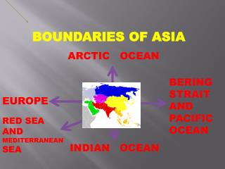
BOUNDARIES OF ASIA. ARCTIC OCEAN. BERING STRAIT AND PACIFIC OCEAN. EUROPE. RED SEA AND MEDITERRANEAN SEA. INDIAN OCEAN. Northernmost Point : Cape Chelyuskin Westernmost Point: Cape Baba Burun Easternmost Point: Cape Dezhneva Lowest Point: Dead Sea (408 m below sea level)

E N D
BOUNDARIES OF ASIA ARCTIC OCEAN BERING STRAIT AND PACIFIC OCEAN EUROPE RED SEA AND MEDITERRANEAN SEA INDIAN OCEAN
Northernmost Point : Cape Chelyuskin • Westernmost Point: Cape Baba Burun • Easternmost Point: Cape Dezhneva • Lowest Point: Dead Sea (408 m below sea level) • Highest Point: Mt. Everest (8,848 m above sea level)
Separates: • Asia & N. America: Bering Strait • Asia & Africa : Suez Canal • Asia & Europe : Ural Mountains
Notable Landforms • Mt. Everest : highest mountain in the world • Pamir Knot : known as “Rooftop of the World” • Mt. Fuji: highest volcano in Japan • Mt. Mayon: A perfect coned-shape volcano • Taal Volcano: smallest volcano in the world • Tibet: largest plateau in the world • Indonesia: largest archipelago in the world
The Top Five Geo The five highest mountains in Asia: 1. Mount Everest2. K2 3. Kanchenjunga4. Lhotse5. Makalu
The Top Five Geo The five biggest lakes In Asia - km2: 1. Caspian Sea2. Lake Baikal3 Lake Aral4. Lake Balkhash5. Isyk-Kol
The Top Five Geo The five largest riversIn Asia 1. Yangtze kiang2. Ob-Irtysh3. Yenisey4. Yellow River5. Irtysh
The Top Five Geo The five biggest islandsin Asia 1. Borneo2. Sumatra3. Honshu4. Sulawesi5. Java
The Top Five Geo The top five biggest cities in Asia- in million population 1. Tokyo2. Seoul3. Mumbai4. Jakarta5. Delhi
REGIONS OF ASIA NORTH ASIA EAST ASIA WEST ASIA SOUTHEAST ASIA SOUTH ASIA
E A S T A S I A CHINA JAPAN TAIWAN NORTH KOREA SOUTH KOREA MONGOLIA
S O U T H E A S T A S I A BRUNEI CAMBODIA EAST TIMOR INDONESIA LAOS MALAYSIA MYANMAR PHILIPPINES SINGAPORE THAILAND VIETNAM
SOUTH ASIA BANGLADESH BHUTAN INDIA MALDIVES NEPAL PAKISTAN SRI LANKA
W E S T A S I A AFGANISTAN BAHRAIN CYPRUS *TURKEY IRAN *UNITED ARAB EMIRATES IRAQ ISRAEL JORDAN *YEMEN KUWAIT LEBANON OMAN QATAR SAUDI ARABIA SYRIA
ARMENIA AZERBAIJAN GEORGIA KAZAKHSTAN KYRGYZSTAN RUSSIA TAJIKISTAN TURKMENISTAN UZBEKISTAN NORTH ASIA
Climate and Weather of Asia Asia has a wide variety of biomes and climates, from the highest coldest mountain peaks in the Himalayas to the deserts of the Middle East.
The great interior lands of Asia are far from the ocean. Winds from the oceans are cut off by the high mountain chains which surround the interior. Because of this, the climate of central Asia is one of extremes. Winters are long and cold, chilled by cold winds from the polar regions. Summers everywhere but the highlands are short and hot. Except in the mountains, there is little rainfall. Consequently, much of the region is desert. Central and Northern Asia Climate Northern Asia has much the same sort of climate as central Asia, except that is has more rainfall. Winters are extremely cold-the coldest inhabited place in the world is a village in Siberia called Verkhoyansk. The temperature there sometimes drops to 90 degrees below zero.
It is hot here all year round, except in the mountains. 2. The temperature in the lowlands may reach as high as 125 degrees. 3. no summer and winter 4. a rainy season and a dry season. 5. Rainy Season: June through October.. Some areas in India get more than 450 inches of rainfall during the rainy season. 6. The rainy and dry seasons are caused by winds called monsoons, which blow from central Asia toward the southern and eastern edges of the continent. Winter monsoons are dry winds because they blow over dry land. They are cold because they come from a cold region. Summer monsoons blow inland from the oceans, bringing moisture as far inland as they reach. Southeast Asia and Monsoons
Asia Summers and Typhoons Asia summers vary with location and altitude. Areas along the coast and just inland are susceptible to typhoons, which bring heavy rain and strong winds. The hurricane tracks in the Atlantic are very similar to the typhoon tracks in the South Pacific
Asia Winter Weather Patterns Winters in Asia vary from cool to extremely cold with the exception of the southern areas. The interior areas are dry, while the coastal areas are humid.
REFERENCES http://www.animated-gifs.eu/phone-240x320-asian/thumb-01.htm http://en.wikipedia.org/wiki/Asia http://www.lib.utexas.edu/maps/asia.html http://www.picsfrom.com/top-5-geo-asia.htm http://www.answers.com/topic/asia http://www.worldatlas.com/webimage/countrys/as.htm http://www.letsgodigital.org/images/artikelen/39/mount-everest.jpg http://encarta.msn.com/encyclopedia_761574726/Asia.html http://www.geographia.com/indx04.htm http://travel.nationalgeographic.com/places/continents/continent_asia.html