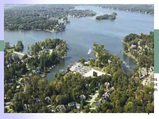
Cuckmere Pathfinder Project Public evidence meeting 5 April 2011
90 likes | 229 Vues
Cuckmere Pathfinder Project Public evidence meeting 5 April 2011. Landscape, Visitors, Heritage and Economy of the Cuckmere: Evidence Presentation Stage 2 Landscape and Visual Assessment David Huskisson Associates . The Brief .

Cuckmere Pathfinder Project Public evidence meeting 5 April 2011
E N D
Presentation Transcript
Cuckmere Pathfinder ProjectPublic evidence meeting 5 April 2011 Landscape, Visitors, Heritage and Economy of the Cuckmere:Evidence Presentation Stage 2 Landscape and Visual Assessment David Huskisson Associates
The Brief • “To identify and assess the likely effects on the landscape character and visual amenity of the valley of various additional options to those identified in the Strategic Environmental Assessment carried out by the Environment Agency and assessed in the Landscape and Visual Impact Assessment in2006. • These options have been identified by the Cuckmere Community Forum and will be agreed with all stakeholders.”
The Options and their groupingAll are assessed against the Baseline (Do Nothing) • Option A: Partial breach managed realignment (EA Option 3a) • Option B: Full breach managed realignment (EA option 3b) • Option C: Engineered reactivation of meanders & meandering creeks • Option D: Maintain the existing defences (EA Option 2a) • Option E: Sustain the existing defences (EA Option 2b) • Option F: Sustain the existing defences
Main findings of Landscape Baseline Statement • South Downs National Park: additional purpose to that of conserving and enhancing the landscape is promoting opportunities for the understanding and enjoyment of the Park’s special qualities by the public. • Countryside and Rights of Way Act 2000 (CROW): designated open access land now in place. • South Downs Integrated Landscape Character Assessment: updates and elaborates earlier character assessment. • The Landscape Baseline Statement and the Heritage Asset Plan identified that landscape features contribute to provide a unique sense of place. • Most of the landscape features should be regarded as having high landscape sensitivity, contributing to the landscape value of Cuckmere Haven. However, these individual component features have not been considered further in this assessment.
Landscape Assessment Undertaken in two parts: • Base Engineering • i.e. earthworks, walls, revetments, piling, etc. • Effects assessed on a landscape character area basis against the Baseline. • Landscape value of each character area ranked as exceptional. • Land cover • i.e. Grassland, saltmarsh, mudflat, standing water, etc . • Assessed against the predicted Baseline changes over time. • The Baseline changes are considered to be in character in the context of an estuarine landscape.
Landscape Assessment - Base EngineeringThe Baseline has no adverse landscape effects unless footpaths relocated Option D No adverse landscape effects, assuming no footpath relocation. Option F Minimal adverse landscape effects, one raising of flood banks by 300mm. Option E Adverse landscape effects, two raisings of the flood banks, totalling 600mm. Option A More adverse landscape effects, including at the Golden Galleon and Foxhole. Option B Notably greater adverse landscape effects, largely from the closing bank to Cell A. Option C Most significant adverse landscape effects, resulting from raising the A259 which outweigh other beneficial effects.
Landscape Assessment – Land coverConsidered against the Baseline prediction for 2061 – 2110A mosaic of saline grassland, intertidal saltmarsh, mud flats, creeks and standing water. Meanders lost in immediate vicinity of Canoe Barn. Option B Closest to the predicted Baseline. Significant interim effects. Option C Distinguished from Option B by re-activated meanders. Most widespread and significant interim effects. Option A Cell A and Foxhole valley remain grassland, elsewhere similar to Options B and C . Some notable interim effects. Option D North of Cell B develops as mud flat. Balance remains much as existing with subtleties in the flood plain landscape still recognisable. Option E&F Similar outcomes predicted, remaining superficially as grassland but with loss of subtleties from the flood plain landscape.
Visual AssessmentConsidered against the Baseline prediction for 2061 – 2110A mosaic of saline grassland, intertidal saltmarsh, mud flats, creeks and standing water. Meanders lost in immediate vicinity of Canoe Barn. Viewing opportunities lost from flood plain. • Options B & C Closest overall to predicted Baseline but distinguished by residual visual effects of the base engineering. Loss of views as for the Baseline. Other views adversely affected in the interim, notably on Option C. Option B preferred due to A259 effects on Option C. • Option A Similar to Options A and B but with some views retained from floodplain footpath and less residual adverse effects. • Option D Preferred over Options E and F due to higher visual interest. • Options E & F Superficially similar to the current situation but attractiveness reduced compared to the current situation and to the Baseline outcome.
ConclusionsWhen compared to the predicted baseline outcome in 2061-2110: Option B Closest correlation. Adverse residual effects of the closing bank in Cell A, but this retains and screens a meander, the Canoe Barn and car park which are beneficial in context of the National Park. Option A Broadly similar. The Canoe Barn and car park would be retained, but like the Baseline, there would be no meanders. Option C Significant adverse residual effects arising from the A259 outweigh other benefits. Isolation of the Canoe Barn and car park are disadvantages in the context of the National Park. Option D Similar to Options E and F but slightly preferred for landscape and visual reasons. Options E & F Least favoured as the resultant landscape and visual quality is reduced both by comparison to existing and against the Baseline prediction but Option E maintains rights of way.