Download
1 / 26
260 likes | 278 Vues
Explore U.S. Space-Based PNT policy, GPS program status, and international diplomatic activities. Learn about system capabilities, modernization program, new civil signals, and satellite-based augmentations. Discover U.S. objectives in collaborating with other GNSS providers.

E N D
U.S. Activities to Promote Global Use of GNSS International Technical Meeting The Institute of Navigation Anaheim, California January 26-28, 2009 Kenneth Hodgkins Director Office of Space and Advanced Technology U.S. Department of State
Overview • U.S. Space -Based Positioning, Navigation and Timing (PNT) Policy • GPS Program Status • U.S. International Diplomatic Activities
Provide GPS and augmentations free of direct user fees on a continuous, worldwide basis Provide open, free access to information needed to develop equipment Improve performance of GPS and augmentations to meet or exceed that of international systems Encourage international development of PNT systems based on GPS Seek to ensure other international systems are interoperable with civil GPS and augmentations Address mutual security concerns with international providers to prevent hostile use 2004 U.S. Space-Based PNT Policy
Overview • U.S. Space -Based Positioning, Navigation and Timing (PNT) Policy • GPS Program Status • U.S. International Diplomatic Activities
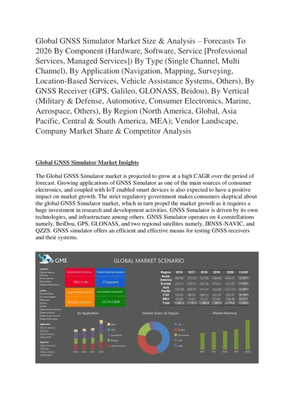
Current Constellation 31 Operational Satellites (Nominal Constellation: 24) • 13 Block IIA satellites operational • 12 Block IIR satellites operational • 6 Block IIR-M satellites operational • Transmitting new second civil signal (L2C) • 2 Block IIR-M satellites remain to be launched • Continuously assessing constellation health to determine launch need • IIR-M launches planned for Mar and Aug 2009 • First IIF projected for launch in late 2009 • Global GPS civil service performance commitment met continuously since 1993
Recent Program Successes GPS IIR(M): 3 Successful launches since Oct 07 GPS IIF: Completed all functional and performance tests; Currently in vacuum test GPS IIIA: Awarded to Lockheed Martin Space Systems Company (Newton, PA), May 08 • Operational Control Segment (OCS) • Architecture Evolution Plan (AEP)/Launch & Early Orbit, Anomaly Resolution & Disposal Operations (LADO) switch over – Sep 07 • Alternate Master Control Station fully functional • Next Generation Operational Control Segment (OCX) • Needed for Block III satellites & full functionality of modernized signals • Awarded Phase A contracts to Northrop Grumman & Raytheon, Nov 07
Increasing System Capabilities w Increasing Defense / Civil Benefit GPS Modernization Program Block IIA/IIR Block IIR-M, IIF Block III Basic GPS • Standard Service • Single frequency (L1) • Coarse acquisition (C/A) code navigation • Precise Service • Y-Code (L1Y & L2Y) • Y-Code navigation IIR-M: IIA/IIR capabilities plus • 2nd civil signal (L2C) • M-Code (L1M & L2M) IIF: IIR-M capability plus • 3rd civil signal (L5) • Anti-jam flex power • Backward compatibility • 4th civil signal (L1C) • Increased accuracy • Increased anti-jam power • Assured availability • Navigation surety • Controlled integrity • Increased security • System survivability
GPS Modernization – New Civil Signals • Second civil signal “L2C” • Designed to meet commercial needs • Higher accuracy through ionospheric correction • Available since 2005 without data message • Phased roll-out of CNAV message starting in 2009 • Full capability: 24 satellites ~2016 • Third civil signal “L5” • Designed to meet demanding requirements for transportation safety-of-life • Uses highly protected Aeronautical Radio Navigation Service (ARNS) band • 1st launch: 2009; 24 satellites ~2018
Overview • U.S. Space -Based Positioning, Navigation and Timing (PNT) Policy • GPS Program Status • U.S. International Diplomatic Activities
2004 U.S. Space-Based PNT Policy(Excerpts focused on International Relations) Goals: • U.S. space-based PNT systems and services remain essential components of internationally accepted PNT services • Promote U.S. technological leadership in applications involving space-based PNT services To achieve this, the United States Government shall: • Encourage foreign development of PNT services/systems based on GPS • Seek to ensure foreign space-based PNT systems are interoperable with civil GPS and augmentations • At a minimum, ensure compatibility The Secretary of State shall: • Promote the use of civil aspects of GPS and its augmentation services and standards with foreign governments and other international organizations • Lead negotiations with foreign governments and international organizations regarding civil PNT matters
Satellite-Based Augmentations WAAS (2+1) MSAS (2) EGNOS (3) GAGAN (2) SDCM (2) Planned GNSS • Global Constellations • GPS (24) • GLONASS (30) • Galileo (27) • Compass (30 global and 5 regional satellites) • Regional Constellations • QZSS (3) • IRNSS (7)
U.S. Objectives in Working with Other GNSS Service Providers • Ensure compatibility ― ability of U.S. and non-U.S. space-based PNT services to be used separately or together without interfering with each individual service or signal • Radio frequency compatibility • Spectral separation between M-code and other signals • Achieve interoperability – ability of civil U.S. and non-U.S. space-based PNT services to be used together to provide the user better capabilities than would be achieved by relying solely on one service or signal • Primary focus on the common L1C and L5 signals • Ensure a level playing field in the global marketplace Pursue through Bi-lateral and Multi-lateral Cooperation
IRNSS GALILEO COMPASS QZSS GPS GLONASS The Goal of RNSS Civil Interoperability • Ideal interoperability allows navigation with one signal each from four or more systems with no additional receiver cost or complexity Interoperable = Better Together than Separate
U.S. - Europe Cooperation • 2004 U.S.-EU agreement provides foundation for cooperation • Four working groups were set up under the agreement: • Technical, trade, and security issues working groups have met • Improved new civil signal (MBOC) adopted in July 2007 • First Plenary Meeting successfully held in October 2008 Signing ceremony for GPS-Galileo Cooperation Joint Statement, Oct. 23, 2008 (Michel Bosco, European Commission; Kenneth Hodgkins, U.S. Department of State) Oct. 22, 2008 , EU-U.S. Plenary delegations meeting under the auspices of the GPS-Galileo Cooperation Agreement
U.S. - Russian Federation Cooperation • U.S.- Russia Joint Statement issued in December 2004 • Negotiations for a U.S.-Russia Agreement on satellite navigation cooperation have been underway since late 2005 • Several very productive technical working group meetings have been held: • Active exchange of information regarding future signal designs • GLONASS signal architecture still under discussion within the Russian Government
U.S. - Japan Cooperation • Japan’s status as a world leader in GPS applications and user equipment makes it an important partner • Regular policy consultations and technical meetings on GPS cooperation began in 1996 and led to the 1998 Clinton-Obuchi Joint Statement • Both countries have benefited from the close relationship: • QZSS is designed to be compatible and highly interoperable with GPS • U.S. signed agreements with Japan to set up QZSS monitoring stations in Hawaii and Guam
U.S. - India Cooperation • Policy and technical consultations on GPS cooperation underway since 2005 • One aim is to ensure interoperability between GPS augmentation system WAAS and India’s planned GAGAN augmentation system based on GPS • Another aim is to improve solutions for ionospheric effects • U.S.-India Joint Statement on GNSS Cooperation issued in February 2007 in Washington • Bi-lateral meeting held in Bangalore in September 2007 • Technical Meetings focused on GPS-IRNSS compatibility and interoperability held in January and July 2008, and January 2009
U.S.-China Coordination • Operator-to-operator coordination under ITU auspices • Bi-lateral Meetings at Geneva June 2007; Xian, China May 2008; and Geneva October 2008 • Discussions at multi-lateral Providers Forum at Bangalore, India September 2007; and Pasadena, California December 2008
Asia-Pacific Economic Cooperation (APEC) GNSS Implementation Team (GIT) • Promote implementation of regional GNSS augmentation systems to enhance inter-modal transportation and recommend actions to be considered in the Asia Pacific Region • Reports to Transportation Working Group (TPT-WG) through the Inter-modal Experts Group (IEG)
APEC GNSS recent activities • Thailand with the support of AEROTHAI hosted a GNSS Technological Innovation Summit in May 2008 • Completed the successful $1 million GNSS test bed project, located in Bangkok and funded by the U.S. Trade and Development Administration and supported by the U.S. FAA • Updated the Terms of Reference to take account of environmental benefits • Achieved consensus on a project proposal to survey and assess current applications for surface transportation utilizing GNSS • Adopted a Program of Action
APEC TPT-WG Outcome • The GNSS Implementation Team (GIT) reported to the Inter-modal Experts Group (IEG). • The IEG was impressed with the GNSS Technological Innovation Summit and the GIT 12 Outcomes and forwarded project proposal to APEC. • GIT contributed to the deliberations in all four working groups (Inter-modal, Maritime Safety, Maritime Experts and Aviation). • Interest expressed in learning more about GNSS in the Plenary and in the maritime safety group at the next APEC Transportation Working Group.
International Committee on Global Navigation Satellite Systems (ICG) • Emerged from 3rd UN Conference on the Exploration and Peaceful Uses of Outer Space July 1999 • Promote the use of GNSS and its integration into infrastructures, particularly in developing countries • Encourage compatibility and interoperability among global and regional systems • Members include: • GNSS Providers (U.S., EU, Russia, China, India, Japan) • Other Member States of the United Nations • International organizations/associations
International Committee on Global Navigation Satellite Systems (ICG) • ICG-3 held in December , 2008 in Pasadena, CA • Progress on implementing ICG Work Plan within established working groups: • A. Interoperability and compatibility • B. Enhancement of performance of GNSS services • C. Information dissemination, education, outreach & coordination • D. Interaction with monitoring & reference station network organizations • Regional UN Centres for Space, Science and Technology Education will act as ICG Information Centers
ICG -3 and Providers Forum • Task Forces on Geodetic References and Time References established • ICG and UNOOSA to support regional workshops • GNSS Providers (U.S., EU, Russia, China, India, Japan) • Purpose: • Focused discussions on compatibility and interoperability, encouraging development of complimentary systems • Exchange detailed information on systems/service provision plans • Exchange views on ICG work plan and activities • ICG-4 and Providers Forum to meet September 14-18, 2009, at St. Petersburg, Russia http://www.unoosa.org/oosa/en/SAP/gnss/icg.html
Summary • As new space-based GNSS are emerging globally, interoperability is the key to “success for all” • U.S. is actively engaged in bi-lateral, regional, and multi-lateral cooperation on space-based navigation issues • International cooperation in the context of National Space-Based PNT Policy principles is a top priority for the U.S. Government
Contact Information Kenneth Hodgkins Director Office of Space and Advanced Technology U.S. Department of State 1990 K Street NW, Suite 410 Washington, D.C. 20006 202-663-2398 (office) hodgkinskd@state.gov http://www.state.gov/g/oes/sat/