Download

1 / 25
250 likes | 387 Vues
An Analysis of Terrain and Earthquake Activity. CALIFORNIA. CALIFORNIA. Overview: Earthquakes Information Terrain, Fault Lines and Earthquakes Two Historical Earthquakes Focus on San Francisco city terrain information and predictions. CALIFORNIA. Facts:

E N D
An Analysis of Terrain and Earthquake Activity CALIFORNIA
CALIFORNIA • Overview: • Earthquakes Information • Terrain, Fault Lines and Earthquakes • Two Historical Earthquakes • Focus on San Francisco city terrain information and predictions
CALIFORNIA • Facts: • Area: 158,693 sq mi • Population in 2000: 33,871,648 • Diverse Topogrophy • Over 300 faults in the state • Two mountain ranges
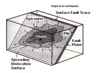
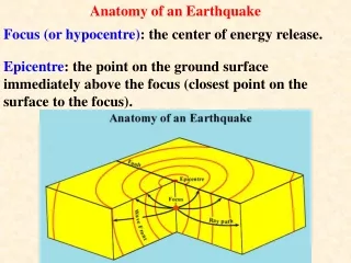
CALIFORNIA What is an Earthquake? An Earthquake is the ground movement or vibration as two blocks of the earth’s crust slip or move suddenly past one another along a fault line or plate. Earth’s blocks move as a release of built up pressure. This pressure is a result of surrounding terrain stress from mountain ranges as well as from the earth’s plates
CALIFORNIA How are Earthquakes measured? Earthquakes are measured by both Magnitude and Intensity. Most commonly know is the Richter Scale measurement which is the magnitude or measure of ground movement on a scale of 1-10. Richter Scale Measure 1-3 Low 4-6 Medium 7-10 High
CALIFORNIA Coast Range Sierra Nevadas Death Valley Coast Range
CALIFORNIA Most famous is San Andreas Fault Zone Not a continuous fault line Stretches over 800 miles San Andreas
CALIFORNIA • Historical Earthquakes • 1906 epicentered on San Francisco Peninsula • Estimated 7.9 magnitude • estimated over 700 deaths and 3000 injuries • 400,000 in population: 225,000 left homeless • over 28,000 building and structures destroyed • by earthquake and fires
CALIFORNIA • Historical Earthquakes • 1989 epicentered in San Jose, just south of San Francisco • 62 deaths, over 7000 injuries • 18,000+ structures damaged or destroyed • 3,000+ homeless
CALIFORNIA 100 meter interval 50 meter interval 75 meter interval
CALIFORNIA Seismic Hazard Zones
CALIFORNIA Predictions for Fault Lines in San Francisco and surrounding area Scientists predict 3000-8000 potential deaths and billions in damages Science & Technology Review https://www.llnl.gov/str/Sep06/Rodgers.html
CALIFORNIA Conclusion The diverse terrain of California is extremely conducive to earthquake activity Viewing the terrain spatially in correlation to the entire ground cover of the state can help to understand the diversity The large population of the state and specifically large cities such as San Francisco which sits on major fault lines are threatened with death and destruction due to earthquakes The threat of the next “big” quake is very real
CALIFORNIA • Suggestions for Further/Future Research • Research and learn more about the statistics used and the how scientists and seismologists predict the actual likelihood of earthquakes to occur on certain fault lines • Investigate further the city of San Francisco and their preparedness for the next “big” earthquake
CALIFORNIA References USGS - www.usgs.gov USGS Seamless Server - http://seamless.usgs.gov/index.php National Atlas - www.nationalatlas.com Exploratorium Education http://www.exploratorium.edu/faultline/index.html Science & Technology Review https://www.llnl.gov/str/Sep06/Rodgers.html San Francisco Government Website http://gispubweb.sfgov.org/ Science Clarified http://www.scienceclarified.com/landforms/Faults-to-Mountains/Fault.html