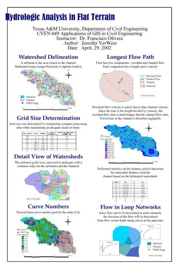
Terrain Analysis
Terrain Analysis. Tactical Diagramming Course. “Terrain for the military man is the same as the chess board for the player …”. Frederick the Great. Terrain Analysis.


Terrain Analysis
E N D
Presentation Transcript
Terrain Analysis Tactical Diagramming Course
“Terrain for the military man is the same as the chess board for the player …” Frederick the Great
Terrain Analysis • Recognized important tactically sinceSun Tzu described it in “The Art of War” circa 500 B.C. and has been used by every successful tactical leader since then • Just as important in urban environments as it is in rural environments • Large malls, buildings, skyscrapers, custodial facilities and the like, can also be analyzed for effects on tactical movements • Terrain analysis is one of the best investments of time for planning
K O C O A Conducting the Analysis • Significance of the terrain will vary with the echelon of command and the particular mission of the unit • Five factors have proven tactical significance. These are: • Key Terrain (Sometimes called Critical Terrain) • Observation and Fields of Fire • Cover and Concealment • Obstacles • Avenues of approach and escape
K O C O A Key Terrain Features • Any locality or area, the control of which, offers a marked advantage • Control is critical, not occupation • Oft times it is the “high ground” but may also be a choke point, obstacle, blind spot or avenue of approach or escape • If the control of dominate terrain offers a decisive advantage it is called, “Decisive Terrain” or “Commanding Terrain” • “Texas Tower” or the tower at theBranch Davidian compound are two good examples
K O C O A Key Terrain is often the “high ground” Key Terrain can also be a “choke point” Key Terrain Features Key terrain can be any feature that offers a marked advantage!
K O C O A Observation andFields of Fire • So closely related that they are considered together • Observation—those features that provide surveillance opportunities • Includes the ability to employ any optic enhancing device, such as binoculars and/or NVGs • Fields of Fire—the area of fire that can be effectively covered depending on the type of weapon and how it is emplaced • Not to be confused with a “sector of fire”
Fields of Fire Characteristics of the weapon is the first factor
Fields of Fire How the weapon is employed is the second factor
Sectors of Fire • Intended to: • Prevent friendly casualties • Increase effectiveness of fires • Ensure no gaps in fires A sector of fire is an assignment!
K O C O A Cover and Concealment • So closely related that they are considered together • Cover—provides protection from fires and the effects of fires • Dependent upon both the weapon employed and the intermediate substance(i.e. tree, concrete, etc.) • Concealment—prevents observation • May be part of terrain, but also smoke, fog, darkness, snow, dust or heavy rain
K O C O A Cover and Concealment(Effects of Fires) Bullets are not the only things that will kill. The “effects” from the fires can be even more deadly and, are easier to hit!
K O C O A Obstacles • Any object or feature that stops, impedes or diverts movement • Depends on mode of movement • Obstacles to vehicles may not impede foot movement • Obstacles may be natural or manmade • Some obstacles are so formidable as to constitute a “barrier”
K O C O A Obstacles for vehiclesmay not stop pedestrians. Some obstacles can be considered “barriers.” Obstacles
K O C O A Avenues of Approachand Escape • A route by which a force can reach an objective or escape from a predicament • Avenues should be broad enough to permit necessary maneuver and bypassing of obstacles • Avoid canalizing friendly forces because it makes them vulnerable (choke point) • Avenues of approach can be vertical, as with a vertical envelopment • Helicopter borne, rappelling, climbing, etc.
K O C O A Avenues of Approachand Escape By foot or vehicle, an avenue needs to be wide enough to permit maneuver and bypass obstacles.
Gaining Terrain Appreciation • Map Reconnaissance • Visual reconnaissance, especially with photographic drive-bys and fly-bys • Visual reconnaissance is necessary to identify: • Steering Features—sometimes called “steering marks,” facilitate navigation • Prominent Terrain—any feature that can be readily identified on both the physical terrain and a map, terrain sketch or diagram • Micro-Terrain —terrain that has tactical significance but is too small to be displayed on a map • Enfilade and Defilade Features —provide “terrain shielding.” Enfilade means exposed to observation or fires and defilade terrain protects against direct observation or fires.
Prominent Terrain Prominent terrain allows precise navigation without a compass, in reduced visibility and/or using only sketches, diagrams or “dead reckoning.” Micro-Terrain?
Observer Terrain Feature(Hill, Valley, Ravine, Building, etc.) Enfilade and Defilade Features Terrain Shielding is the most effective methodof preventing observation while providing cover. Enfilade Defilade