Digital Terrain Analysis: Methods, Representation, and Products in GIS
This lecture focuses on Digital Terrain Analysis, covering essential methods for capturing and representing digital elevation data. Key topics include techniques such as digitizing contour lines, using analytical stereo plotters, ground surveys, and remote sensing methods. The session explores modeling approaches like contour models, TIN, and point models (grid creation), and discusses products generated from Digital Elevation Models (DEMs) including shaded relief maps, slope gradient, and aspect calculations. Students will engage with critical questions to deepen their understanding of terrain analysis practices.


Digital Terrain Analysis: Methods, Representation, and Products in GIS
E N D
Presentation Transcript
Lecture 20: GIS Analytical Functionality (IV) Topics 5. Digital Terrain Analysis Readings on the topics Chapter 12 in Chang (2002): pp. 218-242 Other readings Chapter 5 in Burrough-McDonnell (1998): pp. 121-131 Chapter 8 in Burrough-McDonnell (1998): pp. 183-203
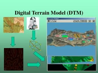
Outlines 5. Digital Terrain Analysis: 5.1 Methods of capturing digital elevation data: (1) digitizing contour lines (2) analytical stereo plotter (softcopy photogrammetry) (3) field sampling (ground survey) (4) radar or sonar sensing 5.2 Methods of representing terrain surface in digital form: 5.2.1 Line Models: Contour models: Often created from digitizing contour lines (Contour Model) Profile models: sampling along a direction (north-south) (Profile Model) 5.2.2 TIN: (The TIN Model) Get the critical points and break lines Create TIN
5.2 Methods of representing terrain surface in digital form: (continued) 5.2.3 Point Model (Altitude Matrix Model, Grid) Creation: (1) Interpolation (such as inverse distance method) from: digitized contour lines field samples (small area, intensive sampling) TIN (2) Softcopy photogrammetry (orthophoto creation) Discussion: easy for deriving topographic attributes data redundancy Comparison of representation models for Elevation (Comparison Figure –Aronoff 4.9)
5.3 Products generated from DEM 5.3.1 Block Diagrams: (Block Diagram) 5.3.2 Transect Lines: (Transect Line) 5.3.3 Flythrough: (3dMapper) 5.3.4 Shaded relief (illumination) maps: Use the difference in reflectance to show the elevation relief over an area. (Lubrecht Shaded Relief Map) 5.3.5 Line of Sight maps or visibility maps (viewsheds) 5.3.6 Slope gradient and slope aspect 1) What are they? Slope gradient is the degree of steepness of a slope Slope aspect is the direction toward which the slope is facing.
5.3 Products generated from DEM: (continued…) 5.3.6 Slope gradient and slope aspect: (continued…) 2) How to compute them? (1) Basic formula: Gradient: Aspect: Where: әz/әx is rate of elevation change in x-direction әz/әy is rate of elevation change in y-direction
5.3 Products generated from DEM: (continued…) 5.3.6 Slope gradient and slope aspect: (continued…) 2) How to compute them? (continued …) (2) Computing the rates of elevation changes: (the partial derivatives) a) Second-order finite difference method: (on the kernel diagram-dzdx-2nd order) (on the kernel diagram-dzdy-2nd order) Where Z represents the elevation of a pixel ∆x is the pixel size in the x-direction ∆y is the pixel size in the y-direction (Example of calculation-2nd order )
5.3 Products generated from DEM: (continued…) 5.3.6 Slope gradient and slope aspect: (continued…) 2) How to compute them? (continued …) (2) Computing the rates of elevation changes: (continued..) (the partial derivatives) b) Third-order finite difference method: (on the kernel diagram-dzdx – 3rd order) (on the kernel diagram-dzdy – 3rd order) (Example of calculation-3rd order) (example image)
5.3 Products generated from DEM: (continued…) 5.3.7 Other products: 1) Drainage networks (Stream Network) 2) Slope partitions (Slope Segments)
Questions: 1. What are ways for capturing digital elevation data? 2. What are the ways for representing digital elevation data? 3. The raster representation is quite easy for computing terrain attributes. Explain why so. 4. What is slope gradient and slope aspect? What are the basic formula to define them, respectively? 5. How the rate of elevation change in x-direction and in y-direction is defined, respectively, under the 2nd order finite difference method? How is this definition different from that under the 3rd order finite difference method? Which one is more accurate? Why?