Download
1 / 35
350 likes | 651 Vues
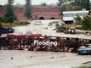
Ancient History Activators #2 Activity takes whole hour. Controlling the Flooding of Rivers. Problem farming created conditions which made civilization possible farming relied on fertile (productive) soil found in river valleys annual (yearly) flooding put farming at risk

E N D
Ancient History Activators #2 Activity takes whole hour. Controlling the Flooding of Rivers
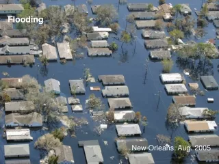
Problem • farming created conditions which made civilization possible • farming relied on fertile (productive) soil found in river valleys • annual (yearly) flooding put farming at risk • farmers needed flooding to be controlled & channeled in order to secure large reliable sources of food • Solution • to build a vast system of levees, channels & reservoirs to control flooding – this required widespread organization and cooperation • as a result leaders had to be given authority to organize farming villages
Vocabulary • Levee • an embankment designed to prevent the flooding of a river. • a natural deposit of sand or mud built up along the side of a river or stream. • one of the small continuous ridges surrounding fields that are to be irrigated.
Vocabulary • Channel • a broad strait connecting two areas of sea • the bed or course of a river, stream, or canal • a means of access • a course into which something can be directed or moved
Vocabulary • Reservoir • a natural or artificial lake or large tank used for collecting and storing water, especially for community water supplies or irrigation
Vocabulary • fertile • bearing, producing, or capable of producing vegetation, crops, etc., abundantly • annual • occurring, done, etc., once a year or every year; yearly • silt • earthy matter, fine sand, or the like carried by moving or running water and deposited as a sediment
Activity • The tables in our room have been divided into two halves facing one another. • They have been separated by 10 feet and taped • The space between the two halves represents a river. • In 30 minutes, I will be releasing 100 marbles between the two sets of tables down the river. • The marbles represent the flood waters and the tables represent the farmlands on the banks of the river. • Your job is to stop the marbles from flooding over the banks and to “capture” the flooding (marbles) so it can be used for fertilization and irrigation. • Even though the floodwater can be damaging it is very necessary because of the silt it carries that fertilizes the farmland.
Team and Materials • The whole class is a team. Your materials… • 100 sheets of scratch paper (to be recycled after activity) • 3 pairs of scissors to use • 3 dispensers of clear tape • Three sets of colored pencils • Each set has a blue, green, red, orange, and brown • 2 meter sticks • 3 rulers
Construct Levees, Channels & Reservoirs • Right in front of the first rows closest to the 10 foot river area
Scoring • Every marble you can stop from leaving the “river” and flooding the “land” = 1 Point. • Every marble that you divert through the channels to the reservoirs = 5 Points. • Your goal is to get as many points as possible by stopping and controlling the “flooding” marbles. • Period 2 = 12 points
Team and Materials • The whole class is a team. Your materials… • 100 sheets of scratch paper (to be recycled after activity) • 3 pairs of scissors to use • 3 dispensers of clear tape • Three sets of colored pencils • Each set has a blue, green, red, orange, and brown • 2 meter sticks • 3 rulers
Creating your structures Half Sheet 1: • 100 sheets of paper that you’ll fold in half hot-dog style and then cut across the crease. • After each sheet is cut in half, the smaller half sheets are folded in half again. fold cut fold Half Sheet 2:
fold LEVEE Color • After the smaller half sheets are folded, you will write the word “Levee”, “Channel” or “Reservoir” depending on what you want to use the piece for. • You will have 3 sets of colored pencils each containing a red, orange, blue, green, and brown pencil • Alternate colors as you label your pieces fold CHANNEL Color fold RESERVOIR Color
Organize • Some students will have to use the 3 pairs of scissors to cut the paper • Some students will fold these papers in half and use the colored pencils to mark each piece using a color pencil • Other students will lay the levee sheets on the floor in the correct pattern • Use tape and secure each levee to one another • What’s the plan?
Making the Levees • Levees are the pieces you will need the most of • Take one colored pencil and write the word “Levee” on one side of the folded half piece • Students creating the Levee will deliver them to the students who are putting the pieces together • Place them on the floor so the two folded ends touch the floor making them freestanding • Place them so they overlap • Tape them together (you may slightly crease the bottom so that they can be taped to the floor) • You can’t tape them to desks, tables, chairs, in any way
Using Levees • Lay levee pieces down on the floor on both sides of the river (space between desk rows) • Levee pieces must be arranged so that no colored marker label is displayed until the other four colors have been placed down • RED, ORANGE, BLUE, GREEN, BROWN, RED, ORANGE, BLUE, GREEN, BROWN • The same color repeats every 6 pieces • You will have to organize yourselves to do this
Channels • Make channel pieces the same as levee pieces • Each channel piece is folded and labeled “Channel” with alternating color markers • Channels are placed and taped perpendicular to the Levee • Width of channel can be NO MORE than 12 inches • Length of channel must be AT LEAST 12 inches • Tape the channel pieces to the levee pieces
Channels • Channel color scheme continues where levee color left off • Channels are meant to capture some of the marbles and direct them to Reservoirs • Channels must be at least 36 inches apart from one another • Make sure you have a length of at least 12 inches and a width of no more than 12 inches • One meter stick and 3 rulers for measure
Making Channels • Build two Channels that will be connected to Reservoirs on both sides of the river • It is through these channels that marbles (floodwaters) are diverted so they can be captured • In the reservoirs floodwaters become still and the fertile silt carried by the current will then sink and then dredged up to fertilize farm land • Reservoirs used as a source of irrigation • Each marble captured in a reservoir is worth 5 points so create four channels that lead to the reservoirs
Making Reservoirs • Circular or rectangular enclosures joined to both sides of the channel • Reservoirs are where marbles are can be captured for bonus points • This simulates the need not only to control the destructive effects of flooding but to also turn it to a benefit (irrigation and fertilization) • Reservoir pieces made in the same way as the Levee and Channel pieces were. • first reservoir piece must be perpendicular to the channel pieces. Make it as big as you wish.
Cautions!!! • You have exactly 25 minutes to get the task completed. • You must organize yourselves, use the materials provided, cut and label the papers, and create the levees, channels, and reservoirs all within that time period. • All class members must contribute. Points will be deducted for non-participation or for leaving or pushing people out.
ISN Page 26 Page 26 ISN – Controlling Rivers’ Flooding: The Birth of Government – 9/27 – Answer following - use color in your diagram • Describe yesterday’s activity. In 3-4 sentences summarize what we did. Some things to include – why did you make levees, channels, and reservoirs? How did this simulate (imitate) problems faced by the first farmers in river valleys? • Draw and label a diagram of the way your class built its river levees, channels, and reservoirs yesterday. • Describe how your class got organized to complete the task. What did your class do that worked well? What things could have been better? Did ancient farmers face the same challenges? Explain your answer.
Problems Ancient People Needed to Overcome to Create Civilizations a stable source of food that would generate a surplus cooperation to control the flooding of rivers an ability to accurately record food supplied to them a way to communicate non-verbally a need for people to feel an attachment to the civilization the ability to introduce new ways of thinking and doing things
ISN Page 27 Page 27 ISN –Vocabulary and Flow Chart (layered) Create a modified vocabulary book with tabs from a sheet of your own college ruled loose leaf paper. • Fold in half hot-dog style. • Draw a line down the fold to divide the book. • Fold each outside edge in to the middle on the fold line. • Trim the plain white top off. • Flip over. • Divide the book the following ways. • draw a line after the first line • Now draw a line every two lines to the bottom of page. You should have 17 lines for vocabulary and one line for labels. fold
Fertile Silt Annual Levee Channel Archeology Anthropology Artifact Irrigation City-state Empire Civilization Specialization Historian Artisan Scribe
What do the following have in common? • Indus • Nile • Tigris • Euphrates • Huang He (Yellow)
What do the following have in common? • They are all rivers where Neolithic civilizations developed started by plans to control flooding in order to farm. • Indus • China, India, Pakistan • Nile • Uganda, Ethiopia, Sudan, Egypt • Tigris • Iran, Iraq, Turkey • Euphrates • Iraq, Syria, Turkey • Huang He (Yellow) • China
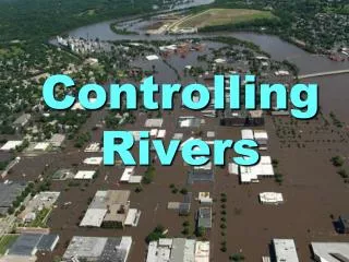
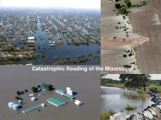
Debrief Controlling the Flooding of Rivers Approximately 5000 years ago the first complex, politically centralized civilizations began to appear independently along a number of river valleys throughout the southern half of Asia, the Middle East, and northern Africa .
A levee, levée, dike (or dyke), embankment, floodbank or stopbank is a natural or artificial slope or wall to regulate water levels. It is usually earthen and often parallel to the course of a river or the coast
Why did the first complex, politically centralized civilizations materialize along rivers? • Because rivers supplied a continuous if not always dependable flow and supply of water for farming and human consumption. • These rivers along with climate, vegetation, geography, and topography shaped the development of the early river valley civilizations. • While people of these civilizations were dependent on the rivers, the rivers also inspired new technological, economic, institutional, and organizational innovations and developments. • Between 3000 and 2000 B.C.E. such river valley civilizations formed independently of each other along the Indus, the Nile, the Tigris and Euphrates, and the Yellow Rivers. These civilizations shared certain characteristics that distinguished them from the collections of Neolithic communities that preceded them.
Summary • Farming revolutionized life by creating a stable food source that could produce surpluses • People could stay in one place • Villages organized in order to controlling flooding and harvest silt for their crops. • Not everyone was needed to produce food • The first city-states developed next to great rivers.