Download

1 / 1
10 likes | 99 Vues
This research paper discusses transitioning improvements in the GOES Sounder profile retrieval algorithm into operations, analyzing comparisons between different versions. It also explains the relevance of continuing product development from current GOES Sounders.

E N D
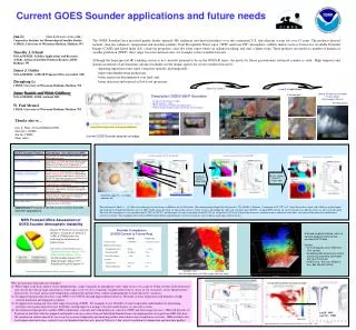
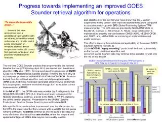
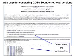
Algorithm development Ma et al (1999) Li et al (2008) Typical comparisons with radiosondes show a mix: for TPW (mm) from this 25 Sep 2011 example, the Ma-version (above) is better at Lake Charles (M37.8, R32.2, L36.3), while the Li-version (below) is better at Slidell (M19.0, R21.2, L19.7). Li-version TPW at 12 UT 25 Sep 2011 Ma-version Research-to-Operations Nodes CIMSSOPDBOSPO Transitioning Improvements in the GOES Sounder Profile Retrieval Algorithm into Operations Gary S. Wade1, James P. Nelson III2, Americo S. Allegrino3, Seth I. Gutman4, Daniel L. Birkenheuer4, Kirk L. Holub4, Zhenglong Li2, Anthony J. Schreiner2, Timothy J. Schmit1, Jaime Daniels5, and Jun Li2 1 NOAA/NESDIS/STAR/CORP/Advanced Satellite Products Branch (ASPB) Madison, WI 2 Cooperative Institute for Meteorological Satellite Studies (CIMSS) – University of Wisconsin Madison, WI 3 IM Systems Group, Inc. Rockville, MD 4 NOAA/OAR/ESRL/GSD/Forecast Applications Branch (FAB) Boulder, CO 5 NOAA/NESDIS/STAR/SMCD/Operational Products Development Branch (OPDB) Camp Springs, MD Question: GOES-R will only have the Advanced Baseline Imager (ABI), and no sounder instrument. What relevance is there to continue to develop products from the current GOES Sounders? Answer: First, four of the “day-1” GOES-R products are “legacy” sounding products: vertical temperature and moisture profiles; total (column integrated) precipitable water vapor (TPW); and, (derived) atmospheric stability indices. Although the ABI will only have one CO2 temperature sounding band (at 13.3 um), the ABI will have three important moisture–sensitive H2O bands (similar to the current GOES Sounders). Despite reduction of thermal vertical information content, the GOES-R vertical profile retrieval algorithm will essentially be the same physical retrieval algorithm as that used with the current GOES Sounders (i.e. solving a perturbation form (from a forecast first-guess) of the radiative transfer equation). Second, until GOES-R(-16) becomes operational (estimated to be no earlier than sometime in 2016), and while some current GOES Sounders may continue to operate nominally through the end of the decade (most probably being GOES-14 and GOES-15), those current GOES Sounders may offer the only, or later, supplemental, frequent atmospheric sounding capability available from the geostationary perspective over the US. Lastly, it is reasonable to expect that use, in the National Weather Service (NWS) forecasting application of GOES-R (legacy) soundings, from the non-sounder ABI, may be not expected to be significantly different than that of current GOES soundings. Whatever practical improvements can still be developed, and implemented, with current GOES soundings, for use in the forecast arena, should help to make the GOES-R legacy sounding all the more relevant when they come on-line. Methods of evaluation Side-by-side comparisons can be further quantified by showing difference images, between the Ma- and Li-version DPI. Note that lesser moist extremes seen with the Li-version DPI are in general agreement with the lesser moist bias and RMS noted in the GPS comparisons. For current real-time animations of DPI difference images, similar to the example shown below, see: http://cimss.ssec.wisc.edu/goes/realtime/compare/idiff/flanis-dpicom4dif.html . One comparison tool has been the side-by-side 4-panel provision in near real-time of the hourly GOES Sounder TPW Derived Product Imagery (DPI), showing both the Ma- and Li-versions. Other variations shown include the other sources of DPI (OPDB or OSPO) as well as the first-guess – the NCEP Global Forecast System (GFS) model. For current real-time animations of comparisons, similar to the example shown to the left (from 25 Sep 2011), see: http://cimss.ssec.wisc.edu/goes/realtime/compare/flanis-dpicom4all.html . Note that the difference image to left shows both dry and moist biases; however, reduction of extreme moist bias with the Li-vers (vs Ma-vers), e.g. over the southeast U.S. around clouds, is viewed as an improvement. Li-version Ma-version TPW at 18 UT 25 Sep 2011 Legend that accompanies the 4-panel difference displays. Another comparison approach employed TPW measured with the Global Positioning System (GPS), which supplies a large set of comparison matches which are not readily available with the traditional just twice daily, widely separated radiosonde network. The NOAA/OAR/Earth System Research Laboratory (ESRL) in Boulder, CO provided a variety of statistical displays comparing GOES products and GPS TPW in near real-time (http://gpsmet.noaa.gov/ssec/). Approximately 150 matches across the central and eastern U.S. were available each hour to the development team. Use of this GPS-based analysis tool facilitated the rapid evaluation and incorporation of software changes into the GOES sounding retrieval system. Ma TPW – Li TPW Although statistics have shown an overall, though small, improvement with the Li-version, examination of individual profiles shows less consistent results, supporting the general recommendation to emphasize integrated quantities (TPW, bulk stability indices), spatial gradients, and temporal trends. For current real-time displays of GOES Sounder DPI and profiles over select regional areas, similar to those shown below, see: http://cimss.ssec.wisc.edu/goes/realtime/scus/begin-scus.html or http://cimss.ssec.wisc.edu/goes/realtime/ncus/begin-ncus.html . Li, Z., J. Li, W. P. Menzel, T. J. Schmit, J. P. Nelson III, J. Daniels, and S. A. Ackerman, 2008: GOES sounding improvement and applications to severe storm nowcasting. Geophys. Res. Lett., 35, L03806 Ma, Xia L., T. J. Schmit, and W. L. Smith, 1999: A nonlinear physical retrieval algorithm - Its application to the GOES-8/9 sounder. J. Appl. Meteor., 38, 501-513 Over the last few years, an improved version of the GOES Sounder retrieval algorithm has been experimentally implemented, tested, and as of this month (Oct 2011), is being moved into operational implementation. The previous algorithm is that of Ma et al (1999); the new version is that of Li et al (2008). Although both methods are physical (versus statistical) in nature, the Li-version employs a number of advantages: (1) a true error covariance (vs correlation coefficient ) matrix of retrieval parameters; (2) an improved fast forward radiative transfer model (PLOD/PFAAST); (3) a new radiance bias adjustment scheme; and, (4) an improved surface emissivity regression scheme. Additional options include a regression first-guess (vs a forecast) and “inverted cone” averaging of the original radiances. The practical steps for the research-to-operations transition follows. First, the Li-version code was implemented (and had been developed) at the Cooperative Institute for Meteorological Satellite Studies (CIMSS) at the University of Wisconsin (UW)-Madison, to run within the Man computer Interactive Data Access System (McIDAS). Secondly, the successfully running McIDAS code of the Li-version was provided to the NOAA/NESDIS/STAR/SMCD/Operational Products Development Branch (OPDB), in Suitland, MD, where it was implemented, and modified to run on the OPDB McIDAS machine. When comparisons between the UW-CIMSS and NESDIS OPDB products evolved over this last year to match satisfactorily, the third step was provision of the NOAA-compliant OPDB code to the NOAA/NESDIS/Office of Satellite and Products Operations (OSPO), last month. The final phase will be monitoring (by all groups) of the OSPO products, as they become available, for verification of correct implementation, and then, eventual provision to the forecast community, specifically for broadcast through the NWS Advanced Weather Interactive Processing System (AWIPS). Concluding remarks Incremental improvements in GOES Sounder profile products have been shown. Nonetheless, advancements remain subtle with the spectrally limited GOES filter radiometer. Retrieval development and application need to be continued to help realize the potential of, and establish practical uses for, GOES-R legacy soundings. Although improved temporal and spatial resolution with GOES-R is anticipated with broad enthusiasm, demonstrating measureable impact from vertical information determined from GOES-R looks quite challenging. Let’s continue to push ahead with current GOES Sounder products, for the betterment of GOES-R legacy soundings! For the last four weeks, the Li-version, in general, has shown small, but persistent, improvement over the Ma-version, with respect to TPW values (mm), both being compared to independent GPS data: Libias is only +0.97 (vs Ma bias of +1.65); and, Li RMS is only 2.7( vs Ma RMS of 4.0). Reduction of systematic error, with the Li-version, appears solid. (Improv-GOES-Sndr-Algo-for-Ops-NWAmtg-BHM-20111021-gsw.ppt)