Download
1 / 22
220 likes | 347 Vues
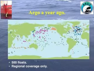
YEAR-LONG MEASUREMENTS OF RAINFALL AND WIND SPEED FROM ARGO FLOATS. Stephen Riser School of Oceanography, University of Washington, Seattle, USA Jeffrey Nystuen Applied Physics Laboratory, University of Washington, Seattle, USA. OUTLINE.

E N D
YEAR-LONG MEASUREMENTS OF RAINFALL AND WIND SPEED FROM ARGO FLOATS Stephen Riser School of Oceanography, University of Washington, Seattle, USA Jeffrey Nystuen Applied Physics Laboratory, University of Washington, Seattle, USA
OUTLINE • Inferring wind speed and rainfall from profiling floats while submerged • Examples of wind and rainfall from the Bay of Bengal measured from a profiling float • A comparison of float-derived rainfall estimates with satellite observations • Future applications of this technique
Rainfall and Wind Speed Measurements from Profiling Floats • There is an acoustic signature to wind and rainfall in the band of frequencies 1-50 khz • The ambient acoustic noise associated with rain and wind is strong enough to be measured at the parking depth of the floats • Wind speed and rainfall can be measured while the float is drifting at the parking depth and the data can be transmitted in the CTD data stream the acoustic rain gauge (ARG)
Oceanic Sound Sources • Geophysical • Wind 500 Hz – 25,000 Hz • Rain 500 Hz – 50,000 Hz • Drizzle 13,000 Hz – 30,000 Hz • Anthropogenic • Ships 100 Hz – 30,000 Hz • Harbors, bridges • Sonars • Biological • Whales tones, clicks • Snapping shrimp snaps (broadband) • other
rain wind 240 khz
note: scatter in the results of 1 m/sec at moderate wind speeds A comparison of anemometer wind speed and acoustically-derived measurements on a TAO buoy in the equatorial Pacific
buoy rain ARG rain A comparison of rainfall inferred from a buoy-mounted rain gauge and acoustically-inferred rainfall on a TAO mooring
2H A float drifting at a depth H receives acoustic energy from a cone of height H and diameter 2H above it H
Hydrophone We have added an ARG (a broad band hydrophone and electronics) to several profiling floats, including UW Argo float 0006. A float should provide a much quieter platform for acoustic measurements than a mooring. [ cost $2K ]
UW Argo float 0006 (WMO ID 2900107), with an ARG installed, was deployed 9/22/2004 in the Bay of Bengal. The ARG performed well through 12/2005.
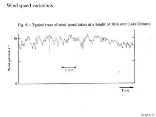
WIND SPEED RAIN RATE SW monsoon (wet) SW monsoon (wet) NE monsoon (dry) 2004 2005 Wind speed and rainfall rate as measured by float 0006 at intervals of 3 hours, 9/04 – 12/05. Rainfall occurs as discrete events.
To assess the quality of the ARG rainfall data from float 0006, the data have been compared to rainfall measurements collected from the TRMM satellite mission. The TRMM data have been gridded at 0.25 latitude/longitude, from 50 S to 50 N, and sampled at 3 hour intervals (TRMM data product 3B42). We have interpolated the TRMM 3B42 data in space and time onto the track of float 0006. TRMM: the Tropical Rainfall Measuring Mission; launched by NASA in 1997; 400 km orbit; rainfall coverage 50S to 50N; footprint 100 km; several microwave sensors
WIND SPEED RAIN RATE TRMM 2004 2005 ARG wind speed and rain rate with the TRMM rain rate estimates added
The probability as a function of time that a rainfall event seen in the ARG data will appear in the TRMM data at a later time.
TRMM ARG The TRMM and ARG compared well over the 15 months: Number of TRMM rain events: 122 Average duration of TRMM events: 5.6 hr Number of ARG rain events: 182 Average duration of ARG events: 5.8 hr Annual total TRMM rainfall: 1206 mm Annual total ARG rainfall: 1107 mm
1000 – 1500 mm [ Peixoto and Oort ] Both the TRMM and ARG-inferred annual rainfall estimates are consistent with climatology for the region
An example of the regional rainfall derived from TRMM on 9/29/04, with the position of UW float 0006 noted 0006
= 18.5 = 19.5 Low salinity surface water appears in the Bay of Bengal as a result of large riverine inputs T-S relation from 53 profiles from float 0006 during the period from 9/04 through 3/06
Surface salinity in the Bay of Bengal can be very low due to rain events and large river input
WIND SPEED 5 m SALINITY TRMM RAIN RATE rainfalleffect rivers/near coast 2004 2005 Surface salinity in the Bay of Bengal is correlated to both position of the float in the basin and rain input events
Conclusions • It is possible to make cost effective, high quality estimates of wind speed and rainfall using passive acoustic techniques on profiling floats (a float is a quiet platform). • The rainfall estimates are of a quality comparable to, or better than, estimates from TRMM. • The rainfall estimates will be especially useful for inferring precipitation in regions where there is no TRMM coverage (poleward of 50), or if satellite coverage is not available. • Using rainfall, wind, and near-surface T/S observations from floats (and other sensors if available) it should be possible to construct models of near-surface mixing and entrainment.