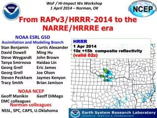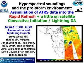
NOAA ESRL GSD Assimilation and Modeling Branch
350 likes | 534 Vues
Hyperspectral soundings and the pre-storm environment: Assimilation of AIRS data into the Rapid Refresh + a little on satellite Convective Initiation / Lightning DA. NOAA ESRL GSD Assimilation and Modeling Branch. Steve Weygandt, Haidao Lin, Ming Hu ,

NOAA ESRL GSD Assimilation and Modeling Branch
E N D
Presentation Transcript
Hyperspectral soundings and the pre-storm environment: Assimilation of AIRS data into the Rapid Refresh + a little on satellite Convective Initiation / Lightning DA NOAA ESRL GSDAssimilation and Modeling Branch Steve Weygandt, Haidao Lin, Ming Hu, Jun Li, Jinlong Li, Tim Schmit, Tracy Smith, Stan Benjamin, Curtis Alexander, John Brown, David Dowell, Brian Jamison, John Mecikalski
RAP: Data assimilation engine for HRRR RAP Hourly cycling model Data Assimilation cycle Observations HRRR
Use of GSI for Rapid Refresh • NCEP, NASA GMAO supported “full” system • Primary development by NCEP for operational DA • Advanced satellite radiance assimilation • GSI used by NCEP for GFS, NAM, and RTMA • NASA GMAO work to create GSI-based 4DVAR • Framework for hybrid ensemble system • Community analysis system • Many users and code contributors • DTC work to make code available to research community • Community-wide SVN code management
Rapid RefreshHourly Update Cycle Partial cycle atmospheric fields – introduce GFS information 2x/day Cycle hydrometeors Fully cycle all land-sfc fields (soil temp, moisture, snow) 1-hr fcst 1-hr fcst 1-hr fcst Back- ground Fields Analysis Fields 3DVAR 3DVAR Obs Obs Time (UTC) 11 12 13
Challenges for regional, rapid updating satellite assimilation • Data availability • -- Long data latency, short data cut-off, small domain • Limited data availability • Bias correction • -- Cycled predictive bias correction in GSI • -- Limited and non-uniform data coverage degrades BC • Lower model top • -- Many channels sense at levels near RAP model top (10 hPa) • -- Use of these high peaking channels can degrade forecast
AIRS Data • Launched May 2002 on NASA Earth Observing System (EOS) polar-orbiting Aqua platform • Twice daily, global coverage • 13.5 km horizontal resolution (Aumann et al. 2003) • 2378 spectral channels (3.7-15.4 µm) • 281 channel subset is available for operational assimilation AIRS Brightness Temperature (BT) simulated from Community Radiative Transfer Model (CRTM)
AIRS Radiance Coverage in RAP • 3 h time window (+/- 1.5 h), in 3-h cycle RAP retro run 06Z 03Z 00Z 09Z 15Z 12Z Brightness Temperature (BT) from AIRS channel 791 18Z 21Z 08 May 2010
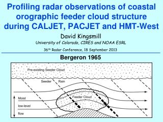
AIRS SFOV Data • Single Field of View (SFOV) soundings derived using CIMSS hyperspectral IR sounder retrieval (CHISR) algorithm (Li et al. 2000) • Clear sky only soundings • SFOV data from CIMSS Sample retrieved soundings compared to radiosondes Typical moisture and temperature biases for SFOV SFOV Raob Dry Warm cold Less vertical structure in SFOV profiles
Diurnal aspects SFOV T innovations (O-B) SFOV Temperature innovations – horiz., daily avg. dependence on height, and time of day AK / Grnlnd Sample SFOV profiles compared with raobs Eastern NA Western NA/AK --- (north) Eastern NA Central NA Western NA/AK West of AK SFOV assimilation 400 -- 800 mb 400 mb 800 00z 03z 06z 09z 12z 15z 18z 21z
Compare AIRS SFOV with Raobs Conditions for matched profiles: 3-h time window, less than 15 km horizontal distance under clear-sky Temp RMS Temp bias 3 SFOV data sets obtained from UW CIMSS: V1 – first set V2 – improved V3 – best set Cool Warm Cool Warm Cool Mixing Ratio bias Improvements in SFOV retrievals All results Shown from V3 Mixing Ratio RMS
Overall Temperature bias (vs. raobs) Comparison of SFOV T to radiosonde data +3h fcst T bias (00z,12z) V1 – first set V2 – improved V3 – best set T SFOV no bias correct CNTL No SFOV cooler warmer Cool Warm Cool Warm • Correspondence between raob comparison and fcst impact • Overall average masks diurnal signal • Model bias as well as observation bias
Histograms of Moisture Innovations (O-B) : Radiosonde vs. SFOV retrievals AIRS SFOV Gaussian distribution, small bias Large dry bias, correction needed? Radiosonde Dry Dry Moist Moist
SFOV Moisture Bias Correction RAP verification against raobs Moisture innovations No bias correction Analysis SFOV NO BC CNTL No SFOV SFOV WITH BC Dry Moist Moisture innovations +15% bias correction 12-h fcst 12-h forecast SFOV NO BC CNTL No SFOV SFOV WITH BC Dry Moist
SFOV T + Qv assimilation: forecast impact CNTL (NO SFOV data) Wind SFOV NO bias correct Relative Humidity SFOV WITH Bias Correct 9-day retro average +12h fcst RMS Combined assimilation of SFOV T and Q (400-800 hPa) with bias corrections reduces +12h forecast RMS (relative to rawinsonde data) for all variables, most levels Temperature
SFOV T + Qv assimilation: forecast impact CNTL (NO SFOV data) Wind SFOV NO bias correct Relative Humidity SFOV WITH Bias Correct 9-day retro average +12h fcst RMS Temperature Normalize Errors EN = (CNTL – EXP) CNTL
SFOV T + Qv assim: normalized RMS errors Vertical average 400-800 mb WITH BC Better NO BC Better Worse Wind Worse Relative Humidity +3h +6h +9h +12h Temp - erature Combined assimilation of SFOV T and Q (400-800 hPa) with bias corrections Small positive impact Better
HRRR case study initialized from RAP 2100 UTC 10 May 2010 0-hr 850-500 hPa mean relative humidity (%) SFOV data NO SFOV WITH SFOV Analysis 850-500 hPa mean relative humidity (%) from RAP AIRS SFOV run SFOV water vapor mixing ratio (g/kg) at 750 hPa Analysis 850-500 hPa mean relative humidity (%) from RAP control run
HRRR case study initialized from RAP 2100 UTC 10 May 2010 +2 hr Forecast Reflectivity Radar data NO SFOV WITH SFOV Observed radar composite reflectivity HRRR forecast reflectivity initialized from control RAP HRRR forecast reflectivity initialized from AIRS SFOV RAP run
Challenges for regional, rapid updating satellite assimilation • Data availability • -- Long data latency, short data cut-off, small domain • Very limited data availability • Bias correction • -- Cycled predictive bias correction in GSI • -- Limited and non-uniform data coverage degrades BC • Lower model top • -- Many channels sense at levels near RAP model top (10 hPa) • -- Use of these high peaking channels can degrade forecast
Two month time series bias coefficients How long a period to adequately spin-up bias coefficient corrections predictors? • Highly variable for different predictors and channels • Some can take two months or more • Problems due to big differences in data coverage for successive cycles (in contrast to global models) AIRS channel 261 (CO2 channel, PWF ~ 840 mb)
Temperature and Moisture Jacobians Standard profile (0.01 hPa top) RAP profile (10 hPa top) Temperature Artificial sensitivity due to low model top in RAP dBT/dT (K/K) Moisture Artificial sensitivity due to low model top in RAP (dBT/dq) * q (K)
Radiance assimilation: forecast impact CNTL (NO AIRS data) Wind AIRS – 120 channels Relative Humidity AIRS – 68 channels 9-day retro average +6h fcst RMS AIRS radiance assimilation with GSI bias correction and channel selection reduces +6h forecast RMS (relative to rawinsonde data) for all variables, most levels Temperature
RAP assimilation of lightning data • Map lightning density to proxy reflectivity • -- sum ground flashes per grid-box • over 40 min period (-30 +10 min) • REFLmax = min [ 40, 15 + (2.5)(LTG)] • Sin distribution in vertical OLD specified relationship: NEW seasonally averaged empirical relationships: LTG and REFLmax REFLmaxand vertical REFL profile
Lightning Flash Rate max reflectivity NEW Seasonally dependent empirical Summer OLD specification in RUC Winter
SUMMER Reflectivity profile as a function of column maximum reflectivity Max dbz 30-35 Max dbz 40-45 Max dbz 35-40 Max dbz 45-50
WINTER Reflectivity profile as a function of column maximum reflectivity Max dbz 30-35 Max dbz 40-45 Max dbz 35-40 Max dbz 45-50
AVERAGE Reflectivity profile as a function of column maximum reflectivity Max dbz 30 - 35 Max dbz 40 - 55 Summer Summer 40 dBz 30 dBz Winter Winter Max dbz 35 - 40 Max dbz 45 - 50 Summer Summer 36 dBz 44 dBz Winter Winter
Applications lightning DA technique Can apply technique to lightning data and satellite-based indicators of convective initiation GLD-360 lightning data -- good long-range coverage Especially helpful for oceanic convection SATCAST cloud top cooling rate data -- good Convective Initiation (CI) indicator Avoiding model delay in storm development SATCAST work by Tracy Smith using data provided by John Mecikalski proxy flash rate = - 2 x cloud-top cooling rate (K/15 min)
Sat obs Radar coverage Rapid Refresh oceanic lightning assimilation example 24 Apr 2012 Observed reflectivity 16z No radar echo Latent heating-based temper-ature tendency Lightning flash rate No radar coverage 16z
Sat obs No radar echo Rapid Refresh oceanic lightning assimilation example 24 Apr 2012 No radar coverage Observed reflectivity 16z 16z 17z 17z 16z +1h GSD RAP forecasts LTG DA slight impact on RAP forecast storm clusters with LTG NO LTG
Assimilation of “satcast” cloud-top cooling rate CI-indicator data Cloud-top cooling rate helpful for initializing developing convection in GSD RAP retro tests 5 July 2012 18z 18z 5 July 2012 SATCAST cooling rate (K / 15 min) IR image 17z
18z+1h 19z WITH satcast assim Obs Reflect Assimilation of “Satcast” cooling rates provides more realistic short-range forecast of convective initiation and development 18z+1h NO satcast assim
18z+2h 20z WITH satcast assim Obs Reflect Assimilation of “Satcast” cooling rates provides more realistic short-range forecast of convective initiation and development 18z+2h NO satcast assim
AIRS Assimilation Summary / Future Work • Small positive impact in RAP forecasts obtained from assimilating of AIRS SFOV data with application of simple bias correction (competing with full mix of conventional observations) • Assimilation of AIRS radiance data in RAP produces small positive impact for winds, temperature, relative humidity and heavy precipitation • Work to address low model top issue • (better channel selection, blend with GFS model, raise RAP top) • Examination bias correction issues and cloud contamination, re-scripting RAP partial cycle to increase cutoff time • Evaluate sensitivity AIRS data in conjunction with other satellite data types
LTG / satellite CI DA Summary • Preliminary evaluation of impact from assimilation of two novel convection indicators: • GLD-360 lightning data • -- good long-range coverage • Helpful for oceanic convection • Satcast cloud top cooling rate data • -- good Convective Initiaation • Avoid model delay in storm development • Qualitative assessment ongoing Plan HRRR runs from RAP w/ and w/o LTG, satcast