Download
1 / 18
190 likes | 297 Vues
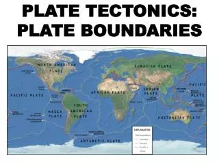
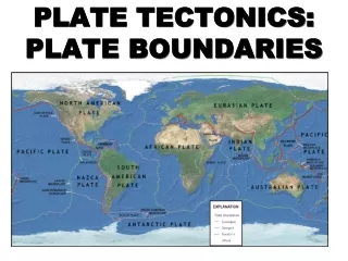
Plate tectonics explains the dynamic nature of Earth's crust, which consists of 12 major plates that interact at boundaries. These boundaries are categorized into three types: divergent, convergent, and transform. Geophysical surveys (including seismic, gravity, magnetics, and electrical methods) provide insights into Earth's size and shape, while geological surveys involve fieldwork and boreholes to collect samples. The movement of these plates leads to earthquakes, volcanic activity, and the formation of mountains and ocean trenches, highlighting the Earth's complex geological processes.

E N D
How do we know what the Earth is made of? • Geophysical surveys: seismic, gravity, magnetics, electrical, Earth size and shape • Acquisition: land, air, sea and satellite • Geological surveys: fieldwork, boreholes, mines
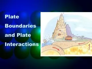
Plate Tectonics • The Earth’s crust is divided into 12 major plates which are moved in various directions. • This plate motion causes them to collide, pull apart, or scrape against each other. • Each type of interaction causes a characteristic set of Earth structures or “tectonic” features. • To determine which type of boundary is present, scientists use evidence of earthquakes and volcanoes
Three types of plate boundary • Divergent • Convergent • Transform
Divergent Boundaries • Spreading ridges • As plates move apart new material is erupted to fill the gap
http://www.geo.lsa.umich.edu/~crlb/COURSES/270/Lec12/spreexamples.jpeghttp://www.geo.lsa.umich.edu/~crlb/COURSES/270/Lec12/spreexamples.jpeg
Iceland: An example of continental rifting • Iceland has a divergent plate boundary running through its middle
Convergent Boundaries • Plates move toward each other • There are three typesof convergent plate boundaries • Continent-continent collision • Continent-oceanic crust collision • Ocean-ocean collision
Continent-Continent Collision • Forms mountains,e.g. European Alps, Himalayas
Collision Zones Two continents hit head-on, crinkling up the land into a high mountain chain.
Continental-Oceanic (Subduction) • Oceanic lithosphere subducts underneath the continental lithosphere • Oceanic lithosphere heats up and melts, then rises, causing volcanism • E.g. The Andes
Ocean-Ocean Plate Collision • When two oceanic plates collide, one runs over the other which causes it to sink into the mantle forming a subduction zone. • The subducting plate is bent downward to form a very deep depression in the ocean floor called a trench. • The worlds deepest parts of the ocean are found along trenches. • E.g. The Mariana Trench is 11 km deep!
Transform Boundaries • Where plates slide past each other Above: View of the San Andreas transform fault