Download
1 / 25
250 likes | 336 Vues
This study aims to optimize GPM precipitation estimates through advanced merging and blending techniques for land data assimilation applications, focusing on water resource management. The project involves dynamic 4D-OA techniques, ANN, Bayesian merging, and downscaling methods to enhance precipitation data accuracy.

E N D
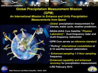
Optimization of GPM Precipitation Estimates for Land Data Assimilation Applications Mississippi State University GeoResources Institute RPC Review (7/10/07) 1
GPM Optimization Team & Collaborators • MSU Team • Valentine Anantharaj • Lori Bruce • Jenny Du • Yangrong Ling • QiQi Lu • Georgy Mostovoy • Louis Wasson • Nicholas Younan • Graduate students • External Collaborators • Paul Houser (GMU CREW) • Joe Turk (Naval Research Laboratories,Monterey, CA) • Partner Agencies • Garry Schaeffer (USDA NRCS) • Steve Hunter (United States Bureau of Reclamation) RPC Review (7/10/07) 2
Team Activity • MSU GRI: Precipitation merging & optimization, modeling, project management, and RPC Integration. • NRL: GPM data, precipitation sensitivity analysis. • GMU CREW: Ensemble Kalman Filter based optimal merging, downscaling, and science expertise. RPC Review (7/10/07) 3
Identified Decision Support Needs • Routine analysis land surface state (soil moisture, evaporation, land surface temperature) over the continental involves: Observations Information Analysis / Modeling • water • soils • sun • weather • climate • vegetation • terrain observe, model, assimilate RPC Review (7/10/07) 4
GPM Evaluations: Purpose and Activities RPC Review (7/10/07) 5
Purpose of RPC Experiment • Optimize the GPM precipitation estimates for decision support in water resources management and other cross-cutting applications. • Characterize and optimize GPM precipitation data by blending and merging with other precipitation measurements and estimates using a Four-Dimensional Objective Analysis (4D-OA) scheme and other intelligent methods. RPC Review (7/10/07) 6
Iterative Experimental Design RPC Review (7/10/07) 7
Experimental Objectives of GPM Optimization • Develop dynamic 4D-OA techniques (EnKF) and intelligent methods (ANN, Bayesian merging) to optimally merge various precipitation estimates. • Evaluate and implement spatial downscaling and temporal disaggregation techniques to derive precipitation forcings for land surface modeling. • Evaluate the optimized and downscaled products by running land surface model experiments at 1 -10 km resolutions in selected domains. • Characterize uncertainties in merged products and in LSM simulations. RPC Review (7/10/07) 8
Tasks to Achieve Objectives • Precipitation Merging • ANN Method • Feature Optimization Technique • EnKF Objective Ananlysis • Bayesian Merging • Precipitation Downscaling • Stochastical-Physical Hybrid Method • Hydrological Modeling • Merged forcings • Downscaled forcings • Analyze results and publish RPC Review (7/10/07) 9
Example Precipitation Products RPC Review (7/10/07) 12
Research Objectives • To combine precipitation-related information from satellite estimates, model predictions, and rain gauge measurements in order to capitalize on the advantages of each product. • To study the impact and sensitivity on land surface states of the final precipitation estimates. RPC Review (7/10/07) 15
ANN Data Merging Neural Network • Multilayer Back Propagation Neural Network (BPNN) • Training: • Inputs: satellite estimates, model predictions, a bias term • Output: gauge measurements • The weights in the BPNN are used to adjust the errors. • Nonlinear regression RPC Review (7/10/07) 16
ANN Data Merging (Cont’d) Investigations to be conducted • Is it reasonable to use gauge measurements as the desired outputs for the neural network training? • When gauge measurements are unavailable, can the interpolated gauge measurements be used as the desired outputs? • If gauge measurements are considered to be noisy, how to modify the neural network training algorithm to accommodate the inaccuracy? • Is there any other choice for the desired outputs? RPC Review (7/10/07) 17
ANN Data Merging (Cont’d) Investigations to be conducted (… continued) • What is the spatial scale for a specific neural network to remain effective (i.e., spatial generalization property)? • What is the temporal scale for a specific neural network to remain effective (i.e., temporal generalization property)? • In addition to the current existing unsupervised neural network-based data merging approach, can a new unsupervised neural network be developed for precipitation data merging? RPC Review (7/10/07) 18
F1 G1 D1 Eliminate Redundant Features FV D2 Precipitation Data Sets F2 G2 Feature Reduction Feature Extraction Merged Precipitation Data Sets Fn Gn Dn Intelligent Feature Optimization Feature Optimization LIS Precipitation Data Model Output Eliminate Redundant Features RPC Review (7/10/07) 19
A Hybrid Approach for Downscaling and Disaggregation of Precipitation • Statistical Downscaling • Physical Downscaling • Hybrid Approach • Stochastic downscaling in space • Physical process based disaggregation in time RPC Review (7/10/07) 21
Space-Time Downscaling-Disaggregation RPC Review (7/10/07) 22
48 km 180 min Radar Observed 3 km 10 min 3 km 10 min Downscaled PrecipitationProduct Compared with Radar Observation GCM equivalent Product Downscaled Product RPC Review (7/10/07) 23
Expected Results[Example only] RPC Review (7/10/07) 24
Issues / Risks • There may not be a physical basis for the performance of the techniques; i.e. the performance (good or poor) may not be explained by relating to a set of physical processes. RPC Review (7/10/07) 25
Schedule RPC Review (7/10/07) 26
Contact InformationValentine Anantharaj<val@gri.msstate.edu>Tel: (662)325-5135 RPC Review (7/10/07) 27
Our Sponsor: NASA Applied Sciences … • NASA's vision is "to improve life here" and our mission is "to understand and protect our home planet". RPC Review (7/10/07) 28
Our Sponsor: NASA Applied Sciences … • NASA's vision is "to improve life here" and our mission is "to understand and protect our home planet". Applications extend the NASA vision and mission by enabling and facilitating the assimilation of Earth observations and prediction outputs into decision support tools. The purpose is to enhance the performance of the decision support resources to serve society through Earth exploration from space. RPC Review (7/10/07) 29
Precipitation Data Model r = rT+b+n r: observed data rT: true data b: bias (constant systematic error) n: random error RPC Review (7/10/07) 30