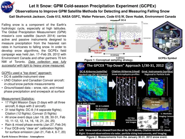
Download

1 / 12
190 likes | 445 Vues
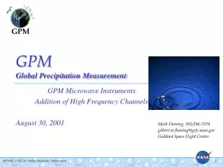
GPM Global Precipitation Measurement. Advanced Study Formulation Jim Adams & Eric Smith ; NASA/Goddard Space Flight Center May - 2001. Objectives of GPM Advanced Study. Primary Goals Define Mission Requirements Negotiate National-International Partnerships

E N D
GPMGlobal Precipitation Measurement • Advanced Study Formulation • Jim Adams & Eric Smith ; NASA/Goddard Space Flight Center • May - 2001
Objectives of GPM Advanced Study • Primary Goals • Define Mission Requirements • Negotiate National-International Partnerships • Gain Agency Approval for Formulation Phase with Single Concept • Examine Options under Trade Space Study • Complete Independent Assessment (IA) • Options Fully Explored • Sufficient Justification for Proceeding with Recommended Option • Select Mission Concept & Proceed to MCR • Define Scope & Instrument Suite to Meet Science Requirements • Adequate Rationale to Selection Official to Begin Acquisition
GPM Trade Space H2-A Dual Launch Configuration • Partnership Development • Mission Architecture • Science Requirements • Measurement Approach • Radiometer(s) • Radar • Validation • Systems Engineering & Effectiveness • Ground Segment & Data System • Programmatic Considerations
Science & Potential Partners NASA HQ/Code Y Mission Oversight NASA Selection Authority International Agreements Interagency Agreements GSFC Project Science Science Data Processing Project Management - Coordination of Intl. Partners - Core & Constellation S/C (RSDO) - MW Radiometer for Const. S/C - Launch of Const. S/C Systems Engineering Mission Architecture Japan (NASDA) DF Precipitation Radar for Core Spacecraft Launch of Core Spacecraft (J-II or H-2A ELV) Repositioning of GCOM-B1 ESA Two Constellation Spacecraft (full up, with launch) Italy (ASI) Passive Microwave Instrument for ESA Spacecraft JPL Advanced Radar Engineering China Repositioning of FY-3 Spacecraft Radiometer Data Stream MSFC-GHCC DIS Component LIS Capability AFWA, NCAR, NRL-FNOC, USDA, USGS Science Products NOAA AMSU 85 GHz Data Stream WSR 88 Data Streams Integrated Rain Product Support Brazil, Canada, Korea, Others National Assets NOAA-IPO SSM/I Data Streams
Science Formulation Activities • Encourage Participation via Workshops, AO’s, & Colloquia • SWT Meetings • International Workshops • GPM Seminars • Future Mission Scope Definition • Systematic Measurement Approach • Developing Operational Agency Involvement • Technology Roadmaps and Infusion Approaches • Refine Primary Science Requirements • Sensitivity Studies in Support of Trades • Define Impact of Data Gaps • Assess Radiometer/Radar Approaches
GPM Partner’s Diagram Italy-GPM (I-CMR) Megha Tropiques (MADRAS) DMSP (SSMIS) DMSP (SSMIS) 7 Core ATMI + ops 6 80% Global Revisit Time (hrs) 90% Global Revisit Time (hrs) 2 3 3 4 4 DPR 6 H2-A GCOM-B1 (AMSR-FO) NASA-GPM (N-CMR) Legend Euro-GPM (E-CMR) IPO Partner-GPM (P-CMR) NASA NASDA
Measurement Approach Trades • Radiometers • Frequencies • 10.7, 19, 22, 37, 85, & higher (?) • Scan Method • conical vs cross track • Antenna Size • orbit altitude • spatial resolution • cost & complexity • Technology Readiness Assessment • e.g., TMI, STAR, SSMIS, CMIS • Radar • Accommodations • Technology Readiness Assessment
Radiometer Possibilities + 150GHz ? ATMI Design (real aperature) STAR Design (thinned array)
Need for Dual Frequency Ku-Ka Band Radar (DPR) Measurable range by 35GHz radar Measurable range by 14GHz radar DPR radar needed to measure intense rain in tropics and weak rain & snow in mid/ high-latitude regions & DSD using differential reflectivity tropical rain mid- & high- latitude rain & snow Frequency weak rain & snow strong rain Rainrate new measurable range by addition of 35GHz radar (T. Iguchi; CRL)
High sensitivity by use of high frequency (target is 11 dBZ, or rainrate threshold of 0.2 mm h-1) Discrimination between rain and snow by attenuation difference Accurate estimation of rainfall rate from attenuation difference in common range (2-15 mm h-1) Merits of Dual-FrequencyRadar Measurement 14GHz radar beam 35GHz radar beam strong scattering weak scattering small attenuation in snow small attenuation in snow small attenuation in rain large attenuation in rain scattered wave with large attenuation scattered wave with small attenuation (T. Iguchi; CRL)
High-Tech Replacement Program Thinned Array Radiometer Real Aperture Radiometer Ka-Ku Band, Polarametric, Doppler Rain Radar Aircraft Prototype AMPR AESMIR PR-2 LRR (STAR) + 150GHz ? Satellite Flight Version CMR SPR-2 ATMI
Data Processing & Dissemination Direct Broadcast • Educational outreach and “3rd world” support • Near real time radiometer data only • Envisioned as inexpensive PC-based system • similar to TIROS Direct Broadcast receiver • quick look rain product generator • software & updates distributed via Internet • Asking all partners to consider Direct Broadcast Near Real-Time Data Processing • 3-hour turn around • No Archive Requirement • Core Spacecraft • processed like TRMM • products and sub-sets distributed via Internet • current TRMM users • NASA/GSFC Laboratory for Atmospheres • ECMWF, JMA, INPE, NOAA-NCEP, NRL, USAF • Constellation Data Streams • individual partners process raw data to rainfall & product subsets • US data center to combine all products into composite rainmap • distributed via Internet Climate Archive • Single data processing system (NASA responsibility) • processes raw data from all GPM satellites/sensors & data streams • ensures consistent cross-calibration • ensures rainfall products are sensor invariant • creates composite rain products • Approximately 2-day processing time • Permanently archived