Download
1 / 14
230 likes | 635 Vues
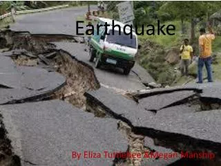
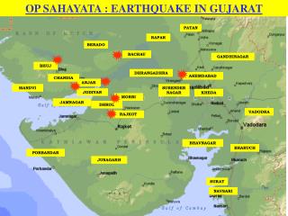
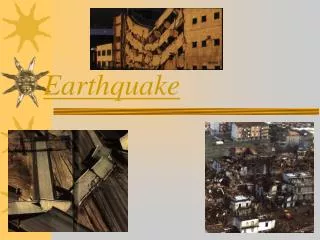
2001 Bhuj Earthquake. Meredith A. Langstaff. Earthquake Basics. M W 7.6 on Jan. 26, 2001 in the Indian state Gujarat > 20,000 killed 150,000 injured ~ 1 million homes destroyed ~ $10 billion in damage Numerous reports of liquefaction and sand blows > 4000 aftershocks.

E N D
2001 Bhuj Earthquake Meredith A. Langstaff
Earthquake Basics • MW 7.6 on Jan. 26, 2001 in the Indian state Gujarat • > 20,000 killed • 150,000 injured • ~ 1 million homes destroyed • ~ $10 billion in damage • Numerous reports of liquefaction and sand blows • > 4000 aftershocks Source: Rastogi (2004)
Tectonic Setting • Convergence to North • Bhuj considered an intraplate earthquake • Known as a seismically active region • Last large earthquake the 1819 Allah Bund earthquake, thought to be same size as 2001 event • Perhaps best analog for New Madrid Seismic Zone Source: Antolik and Dreger (2003)
Regional Instrumentation • No regional seismic or GPS networks at time of rupture • No strong ground motion records at site of earthquake • Multiple teams set up temporary networks in the weeks to month after the mainshock • Most studies analyze the aftershocks Source: Mandal et al. (2004)
Causative Fault • Numerous aftershock studies (Mandal et al. 2004; Bodin et al., 2004) confirm an E-W trending blind thrust dipping ~ 45 degrees to South • Depth: 10-45 km • Reactivation of failed rift from Gondwana • Reactivated ~40 mya as a result of collision with Asia • Anomalously high stress drop ~20MPa Source: Bodin and Horton (2004)
Observed Ground Motions • Hough et al. (2002) compiled personal and media reports of damage • Assigned Modified Mercali Intensities (MMIs) at locations • Create intensity distribution from a continuous-curvature gridding algorithm • Heaviest damage to West of fault • Finite-fault source model for ground motions under-predicts data • Media bias? Building vulnerability? Nature of shaking for intraplate earthquakes? Hough et al. (2002)
Slip Distribution • Antolik and Dreger (2003) used finite fault slip inversion to find slip distribution • Most slip occurs close to hypocenter • Few aftershocks in hypocenter region • Preferred model limits slip at surface • Primary rupture upwards and to northwest • Second region of slip in shallower part of fault, west of hypocenter. • West component of directivity to match ground motions? Antolik and Dreger (2003)
Aftershock Studies • Aftershocks observed to depths > 30km • Bimodal distribution: peaks at ~26km and ~10km • Bodin and Horton (2004) argue aftershocks are consistent with deep slip during the mainshock • Reflect bimodal depth dependent brittles-strength profile for thrust faulting? • Other interpretation: lack of aftershocks in region of mainshock • Several authors report high Vp region surrounding mainshock - volcanic intrusion from rifting? Source: Bodin and Horton (2004)
Fluid-Driven Earthquake? • Kayal et al. (2002) and Mishra and Zhao (2003) report estimates of crack density (), saturation rate (), porosity (), and Poisson’s ratio () from Vp and Vs aftershock measurements • Hypocenter located in region of high Vp, low Vs, and high- , high- , high- , and high- • Infer fluid-filled, fractured rock matrix Source: Mishra and Zhao (2003)
Analog for New Madrid? • Bodin et al. (2004) aftershock study finds similar ground motion attenuation • New study (Miao and Langston, 2008) finds India more similar to Southern California Source: Bodin et al. (2004) Source: Miao and Langston (2009)
Diffuse Plate Boundary Theory • Some argue only ~400km from plate boundary • In US terms, the location of Nevada • Seismicity may be a product of diffuse plate boundary • Stein et al. propose formation of ‘Sind Block’ microplate • High stress drops associated with intraplate earthquakes • Slip orientation consistent with compressional stresses from Indian plate collision
A Note on Geology… • Although didn’t rupture surface, several surface features have been mapped • Sand blow craters may include records of past seismicity Source: Rajendran et al. (2001) Source: Rajendran et al. (2002)
Conclusions • Possible intraplate earthquake may be an analog for other continental seismicity • Two regions of slip: one at depth and one closer to surface • Bimodal distribution of aftershocks may indicate deep slip during mainshock • Calculations from Vp and Vs measurements suggest fluid-filled, fractured rock matrix • Not everybody agrees! Interplate/Intraplate? Analog for New Madrid?
References • Antolik, M. and D. S. Dreger (2003). Rupture process of the 26 January 2001 MW 7.6 Bhuj, India, earthquake from teleseismic broadband data. Bull. Seism. Soc. Am. 93 (3), 1235-1248. • Bodin, P. and S. Horton (2004). Source parameters and tectonic implications of aftershocks of the MW 7.6 Bhuj earthquake of 26 January 2001. Bull. Seism. Soc. Am. 94 (3), 818-827. • Bodin, P., L. Malagnini, A. Akinci (2004). Ground-motion scaling in the Kachchh Basin, India, deduced from aftershocks of the 2001 MW 7.6 Bhuj earthquake. Bull. Seism. Soc. Am. 94 (5), 1658-1669. • Hough, S. E., S. Martin, R. Bilham, and G. M. Atkinson (2002). The 26 January 2001 M 7.6 Bhuj, India, earthquake: observed and predicted ground motions. Bull. Seism. Soc. Am. 92 (6), 2061-2079. • Kayal, J. R., D. Zhao, O. P. Mishra, R. De, and O. P. Singh (2002). The 2001 Bhuj earthquake: tomographic evidence for fluids at the hypocenter and its implications for rupture nucleation. Geo. Res. Let. 29 (24), doi: 10.1029/2002GL015177 • Mandal, P., B. K. Rastogi, H. V. S. Satyanaraya, M. Kousalya, R. Vijayraghavan, C. Satyamurty, I. P. Raju, A. N. S. Sarma, and N. Kumar (2004). Characterization of the causative fault system for the 2001 Bhuj earthquake of MW 7.7. Tectonophys.378, 10 • Miao, Q. and C. A. Langston (2008). Comparative study of distance attenuation in the Central United States and Western India. Eastern Section Seismological Research Letters, 79 (3), 446-456. • Mishra, O. P. and D. Zhao (2003). Crack denstiy, saturation rate and porosity at the 2001 Bhuj, India, earthquake hypocenter: a fluid -driven earthquake? Earth & Pl. Sci. Let.212, 393-405. • Rajendran K., C. P. Rajendran, M. Thakkar, and M. P. Tuttle (2001) The 2001 Kutch (Bhuj) earthquake: coseismic surface features and their significance. Cur. Sci. 80 (11), 1397-1405. • Rajendran, K., C. P. Rajendran, M. Thakkar, and R. K. Gartia (2002) Sand blows from the 2001 Bhuj earthquake reveal clues on past seismicity. Cur. Sci.83 (5), 603-610. • Rastogi, B. K. (2004) Damage due to the MW 7.7 Kutch, India earthquake of 2001. Tectonophys. 390, 85-103. • Stein, S., G. F. Sella, E. A. Okal (2002). The January 26, 2001 Bhuj earthquake and the diffuse western boundary of the Indian plate. Plate Boundary Zones, S. Stein and J. Freymueller, Eds., Geodynamics Series 30, AGU, Washington, D. C., 2002