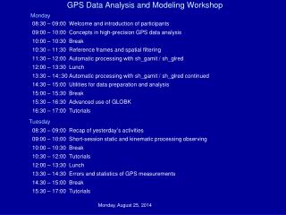
Enabling computational modeling and geospatial data analysis through HUBzero
Enabling computational modeling and geospatial data analysis through HUBzero. Venkatesh Merwade, Lan Zhao, Carol Song Purdue University. Hubbub2013, September 2013. WaterHUB.

Enabling computational modeling and geospatial data analysis through HUBzero
E N D
Presentation Transcript
Enabling computational modeling and geospatial data analysis through HUBzero Venkatesh Merwade, Lan Zhao, Carol Song Purdue University Hubbub2013, September 2013
WaterHUB • Based on HUBzero technology at Purdue, WaterHUB uses open source packages to create an environment in which researchers, educators, and students can access tools and share information
SWATShare • One of the tools on WaterHUB • SWATShare enables • Searching for existing SWAT models on WaterHUB • Downloading of previously created SWAT models and their outputs by the community • Publishing and sharing of your own SWAT models with the community • Execution of single or multiple normal, sensitivity analysis and calibration runs • Visualization of outputs • Everything is enabled by using XSEDE resources
SWATShare User Interfaces View Users can download only their own model and a shared model with associated output files The uploaded models are displayed in 3 groups My Models: models that are uploaded by the current user Shared Models: models that uploaded by other users, but are shared with all users Other models: models that are uploaded by other users but not shared
SWATShare User Interfaces Upload Contents of the zip folder
SWATShare User Interfaces Edit • Select any model from My Model section. Related information will show up in left panel • Manually edit or replace information including the model input file. Click on Change • The Reset button will restore all the original information previously saved
SWATShare User Interfaces Run Selecting a model and clicking the Run button will submit the model to run on one of the XSEDE clusters • A user can import a shared model, and run it in My Models section • SWATShare selects run option (normal/sensitivity/calibration) depending on model’s file.cio and information provided in the Upload interface
Visualization • Visualization for (i) output.std, (ii) output.sub and (iii) output.rch • One variable at a time needs to be selected to produce the visual plot • All plots in output.rch and output.sub correspond to outputs at the watershed outlet
iData- A Community Geospatial Data Sharing Environment • Integrated data publishing, sharing, visualization, and processing for geospatial data collections
DRINET • Drought Impact Viewer http://drinet.hubzero.org
DRINET Tools • Upper Mississippi River and Ohio River Basin Data
Pegasus • A hub tool deployed on geoshare hub • Configure, submit Pegasus crop model simulations to a cluster • Manage and visualize model output http://geoshareproject.org
Maize production tool • A prototype system • Agriculture datasets for maize and climate variables • Weighted average module (GRASS and R) • Data processing, plotting, and download • Flex,Geoserver, GRASS, R, PHP
GABBS • A new project expected to start soon! • Develop geospatial data analysis and modeling building blocks for HUBzero • Data space supporting geospatial data processing, analysis and visualization • New Rappture geospatial APIs and renderers • Data services exposing APIs for the data space • Enable geospatial data driven workflows between data space and tool space
Summary • Tools that support geospatial capabilities to enable simulation models are available for specific models • Geospaital data analysis tools to process and visualize geospatial data are created for several ongoing project • Efforts are underway to develop generic tools support computational modeling and geospatial capabilities within HUBZero to support geosciences applications
Thank you! Contact: Venkatesh Merwade – vmerwade@purdue.edu http://web.ics.purdue.edu/~vmerwade