Download
1 / 23
230 likes | 361 Vues
Hydrometeorological Prediction Center 2011 Review. Kenny James Forecaster. With contributions from Faye Barthold, Mike Bodner, Keith Brill, Mike Folmer, Jim Hoke, Dave Novak, Bob Oravec, Dan Petersen, and Mike Schichtel. 1. Objectives. Summary of HPC operations

E N D
Hydrometeorological Prediction Center 2011 Review Kenny James Forecaster With contributions from Faye Barthold, Mike Bodner, Keith Brill, Mike Folmer, Jim Hoke, Dave Novak, Bob Oravec, Dan Petersen, and Mike Schichtel 1
Objectives • Summary of HPC operations • Verification/Feedback/Future of • - QPF • - Winter weather • - Medium range • - Testbed activities 2
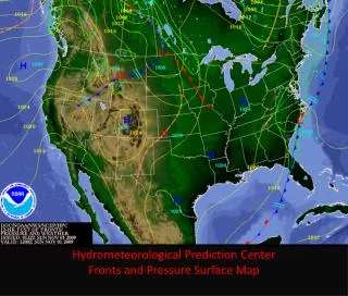
Medium Range Hydrometeorological guidance for: HPC Operations QPF QPF Winter Weather Winter Weather Medium Range • NWS field offices • Other NCEP centers • Federal/state agencies • Aviation • Media • Private sector • International partners • Academic community • General public Model Diagnostics Model Diagnostics Short Term Weather Short Term Weather Surface Analysis Surface Analysis Tropical Tropical Alaska Med. Range Alaska Med. Range Daily Weather Map Daily Weather Map 3
QPF Irene Mississippi Birds Point levee 4
FY11 annual GPRA Goal 0.3, HPC 0.34 – 2nd highest ever % Improvement over NAM 31% % Improvement over GFS 25% % Improvement over ECMWF 13% 5
QPF Feedback • Latest NAM (NEMS-NMMB) shows some improvement over prior version, possibly attributed to less of a slow bias • NAM CONUSNEST shows better skill than parent run • GFS more consistent and reliable since July 2010 implementation, more often the model of choice compared to pre-July 2010 version 7
NAM & GFS Positional biases continue for MCSs From Yost and Schumacher, 2011 8
0.25” in 6h @ F24 May 2010 – June 2011 Perfect SREF SREF Mean/spread useful - contribute to variance for PQPF, but also overconfident SREF overconfident HPC PQPF – Gaining popularity! 9
Hi-res NMM/ARW Often improve upon the north bias for MCSs Still a high bias with many false alarms Missed have them July 19/20 during record flooding due to preemption for tropical invest systems Contribute to a hi-res ensemble suite (SSEO) compiled at the SPC 10
HPC Deterministic Snowfall East of the Rockies x 100 Heavily influenced by 2 major snowstorms, which models had difficulty with 12
HPC Deterministic Snowfall East of the Rockies . 13
Winter Wx Feedback New NAM too deep with lows Oct 28, Nov 1, 8, 28 - influences precip type & snow amounts in our WWD blender, forecasters less confident - Image from WFO La Crosse 15
Winter Wx Feedback Cont. P-type & SN based on microphysics/LSM data Would like additional parameters for our WWD blender - NAM CONEST 700 mb temps - UKMET 78 hr 2m/925/850/700 mb temps Impact-based guidance to assist in decision support and determining societal impacts - SREF prob of ZR (0.1, 0.10, 0.25, etc..), Max SN rate 16
Medium Range 17
Manually Adjusted Days 4-7 Grid Verification vs RTMA 6 upgrades over the past year! 4) GMOS / GFS MEX MOS Hybrid 5) 50 day bias corrected ECMWF and ECMWF Ensemble Mean • RTMA based downscaling • Model 2m temps replace HPC adjusted MOS and GEFS MOS • 3) GMOS replaces MEX MOS 6) 50 day bias corrected GFS and GEFS Mean 18
Medium Range Feedback GFS/GEFS Fast Bias • Verification white • GFS yellow • GEFS members brown too fast 19
Medium Range Feedback GFS MOS Max T day 7 possibly bogus Max T at Roswell, NM much higher 20
Medium Range Feedback NAEFS grids for all NDFD parameters More model guidance for watch/warning decision support & for determining societal impacts - GEFS probs for SN > 4, 8, 12”, ZR > 0.01, 0.10, 0.25” - Heat index > 105, Wind Chill < -15, Wind Speed > 25 or 35 kts Access to parallel runs of the GFS/GEFS without adaptive sounding data Hopeful that the improved NAM leads to a better DGEX 21
Testbed Interactions • Active collaboration with EMC and sister Testbeds • - Spring/Winter Experiments • - Verification & Tools • Helps diagnose model errors & • train forecasters • - Convection-allowing guidance • - Explicit microphysics diagnostics • - New models/post processing • Desire even closer coordination on model /MOS imp. GOES-R Proving Ground 22
Final thoughts & plans • Interpreting hi-res guidance may require a paradigm shift • Native grid resolution desired by forecasters • Clearer file naming convention for models • 2012-16 HPC plans & activities include: - Expand decision support services for high impact events - Extend medium range, including adding probabilities - Increase automation for greater responsiveness 23
Questions? kenneth.james@noaa.gov 24