Toward a Satellite Algorithm Test Bed: Enhancing Data Collection and Environmental Insights
This document outlines the development of a Satellite Algorithm Test Bed (SATB), aimed at advancing space-based data collection and improving environmental monitoring. By leveraging the growing constellation of earth-observing satellites and in-situ data, researchers seek to optimize algorithms, blend sensor data, and enhance the accuracy and timeliness of environmental information. The SATB initiative builds on NOAA's long history of collaboration and aims to fill crucial gaps in the transition from research to operations (R2O) for effective climate understanding and societal impact.

Toward a Satellite Algorithm Test Bed: Enhancing Data Collection and Environmental Insights
E N D
Presentation Transcript
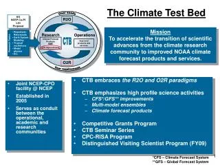
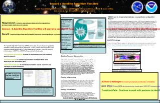
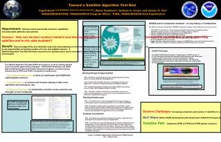
Toward a Satellite Algorithm Test Bed Ingrid Guch1 (GOVERNMENT PRINCIPAL INVESTIGATOR), Steve Goodman2, Andrew S. Jones, and James G. Yoe4 1NOAA/NESDIS/STAR, 2NOAA/GOES-R Program Office, 3CIRA, 4NOAA/NPOESS Data Exploitation Requirement:Advance space-based data collection capabilities and associated platforms and systems Science : How can we best conduct research and develop algorithms using the growing national and international constellation of earth observing satellites and in-situ data available? Benefit: Improved algorithms and ultimately improved understanding of environmental dynamics and climate. Environmental parameters are measured by an exponentially increasing number of in-situ and satellite sensors. A Satellite Algorithm Test Bed will allow researchers to optimize each sensor and blend data to lead to more accurate and timely information about the environment. • NESDIS and its Cooperative Institutes – A Long History of Collaboration The SATB concept was initiated by the NESDIS Cooperative Institutes (CI’s)to build upon successes such as: • 1980 GOES-4 to generate the first geostationary satellite temperature and moisture profiles. • 1989 HIRS instrument used to measure Earth’s outgoing longwave radiation. • 1993 First GOES-8 digital satellite display system at a NWS Office. • 1994 First GOES wind products operationally produced • 2001 First NESDIS focused Cooperative Science Center (workforce development, NESDIS treats as “honorary CI” – technically it is a “CSC” with slightly different regulations) • 2003 First NESDIS CI with ocean focus • Today transitions to operations continue to improve at NESDIS due to more interactions between CIs, STAR’s Operational Products Development Branch and Satellite Operations personnel The primary gap to fill according to SATB stakeholders is related to the early stages of R2O. Once a research concept is proven useful there are several existing opportunities to move it to operations (other NOAA Testbeds or transition programs). GOES-R Prototype The GOES-R Risk Reduction program is supportive of the SATB concept. In FY10 five new projects began that incorporate SATB concepts such as the use of multiple satellite sensors and/or in-situ and model data to conduct research/exploration of relevance to major societal issues. The PIs for the selected projects are being asked for their ideas to improve the existing SATB Development Plan. Components of Research to Operations (R2O) and associated phases. The Satellite Algorithm Test Bed encompasses the early stages of R2O and facilitates the orderly progression of science into later stage R2O processes. • The Satellite Algorithm Test Bed (SATB) will consist of currently existing satellite research funding opportunities (examples: GOES-R Risk Reduction and GOES Improved Measurements and Product Assurance Program), currently existing infrastructure at STAR and STAR’s Cooperative Institutes plus • New research opportunities to allow for multisensor and POES/LEO-related applied research, • New infrastructure to connect and increase sharing of data, tools, algorithms and techniques, and • Enhanced coordination to standardize scientific review, selection and oversight of work conducted. Combined Geo/Leo High Latitude Atmospheric Motion Vectors Geostationary satellites provide Atmospheric Motion Vectors (AMV) equatorward of ~60° latitude; polar satellites provide AMVs poleward of ~70° latitude. • Existing Research Opportunities PRO: Transitions into operations have been improving (money and time spent) for current GOES and POES algorithms, CON: Research that should be done prior to deciding to transition the algorithms is frequently missing, particularly for POES/LEO satellites. PRO: Algorithm development funds are currently available from sources such as POES, GOES, NPOESS, GOES-R, and NPP. CON: “Stovepipe” funding structure has not facilitated consistency of products across platforms or a truly science-centric development of multi-instrument, multi-platform products. Developing novel ways to fill this gap is the next step in providing complete wind coverage for NWP applications. Data from a variety of satellites are blended and used for AMV generation. The images are composites of the Geo (GOES, Meteosat-7 and -9, FY-2C, MTSAT-1R, Kalpana-1) and Leo satellites (NOAA-15 through NOAA-19, Metop-A, NASA’s Terra and Aqua). Investigators: Matthew Lazzara – PI (SSEC), Dave Santek (CIMSS), Chris Velden (CIMSS), Jeff Key (STAR), Jaime Daniels (STAR) Sample GOES-R Project funded in FY10 incorporating GEO/LEO satellite data streams for algorithm explorations. Content courtesy of Matthew Lazzara/SSEC • Existing Infrastructure PRO: The infrastructure for generating algorithms from several types of satellite data streams is currently available at the CIs, CREST and NESDIS. CON: Each location collects data from a different set of satellites using different software and techniques. Additional infrastructure is needed to allow access to all the primary earth observing satellite data streams and tools for research and development of algorithms by the CIs and NOAA. An SATB development plan was created with numerous input from stakeholders Science Challenges:Increasing complexity and number of satellites in combination with increasing expectations for environmental parameter coverage, accuracy, refresh and timeliness. Next Steps:Refine SATB development plan based upon GOES-R Prototype projects and other new information. Transition Path: Implement SATB at STAR and STAR partner locations • Existing Coordination PRO: Coordination for algorithm development typically is conducted at the working levels via Satellite Product Oversight Panels. CON: In the 1990s there was a Satellite Research Council providing high-level coordination in close collaboration with the Product Oversight Panels and Satellite Products and Services Review Board. However in the 2000s funding for satellite research became so scarce that the Satellite Research Council was disbanded. This coordination Is now primarily done less formally via the STAR management structure. A workshop was held at the National Satellite Operations Facility in Suitland, MD, on February 26 - 27, 2008 to define the coordinated activities for the SATB to be established, demonstrated, and maintained. Participants included those who have experience and insight to share regarding both the technical and programmatic aspects of operating test beds, developing, implementing, and supporting environmental satellite data products, and using or coordinating the use of satellite data.