NEW ORLEANS – WHEN TECHNOLOGY DOES NOT WORK mardi gras
540 likes | 812 Vues
NEW ORLEANS – WHEN TECHNOLOGY DOES NOT WORK mardi gras. New Orleans - located in southeastern Louisiana, Bounded by parishes of St. Tammany (north), St. Bernard (east), Plaquemines (South)and Jefferson (south west). New Orleans – AKA

NEW ORLEANS – WHEN TECHNOLOGY DOES NOT WORK mardi gras
E N D
Presentation Transcript
New Orleans - located in southeastern Louisiana, • Bounded by parishes of St. Tammany (north), St. Bernard (east), Plaquemines (South)and Jefferson (south west)
New Orleans – AKA • Crescent City – course of Lower Mississippi River around and through the city
New Orleans – AKA • The Big Easy – by musicians (20th Century – ease of finding work), during prohibition, one time cheapest city to live in US • City that care forgot (1938) – outwardly easy-going, carefree nature of many
La Nouvelle-Orléans founded May 7th, 1718 by French Mississippi Company • City – named after Philippe d’Orléans (Duke of Orléans – regent of France)
Site • Mississippi River (city located on banks) • 169km up river from Gulf of Mexico • Area 902km2 (467.6 km2 – 51.55% is land) • Lake Pontchartrain (north) • Lake Borgne (east)
Orignal city settled on natural levees or high ground along mississippi river • Lakes, marshlands, and bayous extend from the city in all directions
A humid, semi-tropical climate in New Orleans is kept from extremes by surrounding waters • AverageTemperatures:January, 10.7° C; July 27.7° C; annualaverage, 20.1° C • AverageAnnualPrecipitation:1571.8 mm (wet) • Hurricanes pose greatrisk
Elevation: Ranges from 5 feetbelowsealevel to 15 feetabove; meanelevation, 1-2 feetbelowsealevel • 51% of city isat or abovesealevel • More densleypopulated higherground (more $$$ alsohigher)
situation • Located close to the gulf of Mexico
situation • Mouth of Mississippi (from Great Lakes to GOM) river
function • Trade – along trading route and portage between Mississippi and Lake Pontchartrain (French) • City centre of commerce during late 1700 (sugar) • Transportation hub and distribution centre
function • One of the largest and busiest ports in the world (5th largest in US • Oil refining and petrochemical production • White collar corporate base (onshore/offshore petroleum and natural gas production
Technology • Turn of 20th century – drainage plan by engineer and inventerA.BaldwinWood Wood invented “flapgates” and other hydraulic devices (pumps) • Wood Screw Pump (1913) and Wood Trash Pump (1915)
Technology • Designed to expand the city (geographically) despite surrounding swamp • Prior urban development limited to higher ground – natural river levees and bayous
Technology • Wood’s pump system drain huge tracts of swamp and marshland • City expanded into low-lying areas • Over 20th century – rapid subsidence (natural and human induced left new populated areas several feet below sea level
Technology • vulnerable to flooding even before the city's city expansion into low lying areas • late 20th century, however, scientists and New Orleans residents gradually became aware of the city's increased vulnerability
Technology • 1965 – hurricane Besty killed dozens (most city dry) • May 8th, 1995 flood(rain)demonstrated weakness of pumping system
Technology • After floods – measures undertaken to dramatically upgrade pumping capacity • By 1980’s-90’s became clear extensive, rapid and ongoing erosion of the marshland & swamps • Gulf Outlet Canal left city more exposed to hurricane storm surges
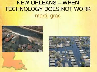
1958 2009
Hurricane Katrina • Aug. 29th, 2005 • Winds category 3, frequent intense gusts and tidal surge
Hurricane Katrina • Most severe portion of hurricane missed the city • 22’ storm surge caused 53 breaches in drainage and navigational canal levees • Worst engineering disaster in US
Hurricane Katrina • 17th street canal, industrial canal and London Avenue Canal levee breached • Aug. 31st 2005 80% of city flooded • Some parts 15’ under water • lower 9th ward
Hurricane Katrina • 90% of city evacuated (1st mandatory evacuation) • 10% remaining – elderly and poor • Superdome was used as shelter
Hurricane Katrina • Reasons for staying – homes would be enough protection, lack of $$$, no transportation, protection of property • Evacuation for Ivan resulted in many eldery sick due to long waits (6-10 hours) • 1 million left , 100,000 stayed • 20,000 in superdome
Rescue Efforts • Disruption of communication infrastructure – cell phone, land line phones, internet access not working • Local TV stations disrupted • Most roads in & out of city damaged • Only route out of city I-10 Twin Span Bridge Collapsed
Rescue Efforts • Disruption of communication infrastructure – cell phone, land line phones, internet access not working • Local TV stations disrupted • Most roads in & out of city damaged • Only route out of city I-10 Twin Span Bridge Collapsed
Rescue Efforts • Lake Pontchartrain Causeway – emergency traffic only • Louis Armstrong International Airport – humanitarian and rescue operations • August 30th – governor Kathleen Blanco ordered complete evacuation of those that remained Astrodome in Houston Texas
Hurricane Katrina • Faulty design specifications, incomplete sections, substandard construction of levee segments contributed to flooding • Flooding of 2/3rd of city could have been prevented
Hurricane Katrina • Engineering failure lawsuit against US Army Corps of Engineers (USACE) – builders and designers of levee system (Flood Control Act 1965) • Jan. 2008 responsibility failure and flooding blamed on USACE but they could not be held financially liable due to sovereign immunity in Flood Control Act 1928
Katrina Aftermath • Looting • Gretna • Danziger Bridge
Heath Concerns • Dehydration • Food poisoning • Spread of hepatitis A, cholera, tuberculosis, typhoid fever (contamination of food and H2O supplies) • Sept. 6 – E. coli detected in H2O supply
Population • Pop 2005 (pre-Katrina) – 454,865 • 2010 – 60% African American, 33% white, 2.9% Asian, 5,3% Hispanic • 20,000-14,000 illegal immigrants (Mexico) • Migration to New Orleans – people returning, result of global financial crisis of 2008-2009
Economic Impacts • Pre-Katrina – economy dependent on transportation, entertainment & public services • Labour force – loss of 70,000 jobs (service) • Construction sector – only sector to thrive