Observations
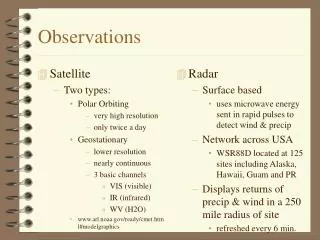
Satellite Two types: Polar Orbiting very high resolution only twice a day Geostationary lower resolution nearly continuous 3 basic channels VIS (visible) IR (infrared) WV (H2O) www.arl.noaa.gov/ready/cmet.html#modelgraphics. Radar Surface based

Observations
E N D
Presentation Transcript
Satellite Two types: Polar Orbiting very high resolution only twice a day Geostationary lower resolution nearly continuous 3 basic channels VIS (visible) IR (infrared) WV (H2O) www.arl.noaa.gov/ready/cmet.html#modelgraphics Radar Surface based uses microwave energy sent in rapid pulses to detect wind & precip Network across USA WSR88D located at 125 sites including Alaska, Hawaii, Guam and PR Displays returns of precip & wind in a 250 mile radius of site refreshed every 6 min. Observations
Hourly Weather Reports (FAA) • Over 1300 airports take weather observations each hour (or more frequently) METAR KABC 121755Z AUTO 21016G24KT 180V240 1SM -RA BR BKN015 0VC025 06/04 A2990 RMK A02 PK WND 20032/25 WSHFT 1715 VIS 3/4V1 1/2 RAB07 POOO3 6OOO9 T00640036 10066 21012 58033
Weather Station Model • Standard approach to representing data