Download
1 / 5
50 likes | 187 Vues
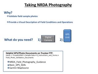
Taking NRDA Photography. Why?. Validate field sample photos Provide a Visual Description of Field Conditions and Operations. GPS Unit. Digital Camera. What do you need?. 1). 2). Helpful GPS/Photo Documents on Trustee FTP:.

E N D
Taking NRDA Photography Why? • Validate field sample photos • Provide a Visual Description of Field Conditions and Operations GPS Unit Digital Camera What do you need? 1) 2) Helpful GPS/Photo Documents on Trustee FTP: Home > TrusteesONLY > Sample Data > 0_Instructions_and_Forms > Field_Photo_Validation_Documents NRDA_Field_Photography_Guidance Basic_GPS_Skills Garmin MapSource
Requisite GPS Settings: • GPS/Camera must be set to local time (Set to 24-hour Military Time) • Garmin GPS: Turn On GPS > Menu > Setup > Time > Time Format = “24 hours” • Datum = “WGS 84” • Turn On GPS > Menu > Setup > Units > Map Datum = “WGS 84” 3) Set Track Log to “Wrap When Full” Turn On GPS > Menu > Tracks > Track Log (Track Log = “On”) > Setup > Check “Wrap When Full” GPS Terms: Tracks and Waypoints Tracks (or “Track Log”):The “breadcrumb trail”; a stream of continuous data points recorded when the unit’s Track Log is turned on, saved to GPS’ memory (ex. overflight path, extent of assessed shoreline) Waypoints: A specific location manually captured by the user and saved to GPS’ memory (ex. location of marine debris object, location of sample).
When using GPS in the field: • Take a photo of your GPS unit with the Date/Time (with seconds!) Clearly Visible • “Menu + Menu” 2) Record a Waypoint when you take a sample When taking photos in the field: • Remember to take multiple photos at each sample point – perspective is important! Take a photo zoomed into the area of interest and then take it in context of the surrounding area. • 2) Take photos to the “tell a story” of the sampling effort (i.e., record other events, other activities of interest)
Returning from the Field: • Connect your GPS unit to your computer (remember your cables) • Start Garmin MapSource • Click on the “Receive from Device” icon. • Click Find Device (the name of your GPS unit will appear) • Under “What To Receive” > Click only Waypoints and Tracks • Click “Receive” (you will now see the tracks/waypoints for that day) • Save .gdb and .gpx files • File > Save As… > “YYYY_MMDD_LastName_FirstName” (Save as type: .gdb) • File > Save As… > “YYYY_MMDD_LastName_FirstName” (Save as type: .gpx) • Provide Comments on Photos where desired (MS word, Excel, txt., etc.) • Fields: • Photo ID • Comment • Key (y/n) • Data (y/n) Example
Post to FTP 2010_0515_Herter_John.zip Scanned COC Documents Sample Data Photos • COC Form • FedEx Labels • NRDA Sample Collection Form • Log Book entries related to samples • Field Sampling form.xls • (either from NOAA Field Sampling Form or “Flat-File” Form) • Photos • .gpx + .gdb file • Doc with Photo Comments