Download
1 / 21
220 likes | 432 Vues
SEAMAP Tasmania- the application of seabed habitat mapping for multiple marine resource management. Miles Lawler Alan Jordan Vanessa Halley. SEAMAP Tasmania- Introduction. Background. Seabed Habitat Mapping Methods. Classification System. Fisheries Based Example. Future Directions.

E N D
SEAMAP Tasmania- the application of seabed habitat mapping for multiple marine resource management Miles Lawler Alan Jordan Vanessa Halley
SEAMAP Tasmania- Introduction • Background • Seabed Habitat Mapping Methods • Classification System • Fisheries Based Example • Future Directions • Visualisation Tools
Mapping completed Mapping in progress Background • SEAMAP Tasmania Project was initiated in 2000 • Aim is to map seafloor habitat within State Coastal Waters, including marine, estuaries and coastal lagoon • Mapping uses aerial photography and extensive ground-truthing • Most mapping done in 0-40m depth range • Cost effective mapping
Southeast Tasmania Tasman Peninsula Multiple Marine Resource Management • Mapping conducted for a variety of management needs including: • marine reserve planning • marine farm planning • fisheries assessment • long term habitat monitoring • baseline environmental surveys
Hierarchical Classification System • Habitat classification based on a hierarchical classification system with set decision rules • Based on a framework recently developed by the National Marine Fisheries Service (Allee et al 2000) • Habitats classified at different levels depending on the aims of the mapping • Mapping at different hierarchical levels requires different techniques
Hierarchical Classification System Based on the framework of Allee et al (2000)
Modifiers • Modifiers may include: • physical structuring • underlying geology • biological communities • depth • exposure • Modifiers are not necessarily mapped and may exist from other data sets. i.e. exposure dense seagrass patchy seagrass sparse seagrass
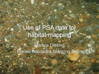
Aerial Photography • Aerial photographs sourced from State Government archives and targeted surveys • Scanned into ArcView 3.2 GIS platform • Used in combination with field transects to define boundary positions • Gives good idea of shape of boundaries and habitat patchiness in shallow water • Limited to ~10m depth in ideal conditions
Sample Aerial Photography Fortescue Bay on the Tasman Peninsula... ….with ‘reef’ boundaries highlighted
Acoustic Field Surveys • Mapping conducted from small vessels (5-6m) in shallow water and larger vessels off shore (~24m) • Single beam sounders (Furuno 600L) on small vessels and recently a Simrad EK60 on offshore vessel • Habitat boundaries and attributes further defined with underwater video
Acoustic Field Surveys • Log depth and differentially corrected position into specially written software, SeaBed Mapper 2.4, which allows habitat attributes to be logged with positional information
Underwater Video • Vertical drop and line transects used to ground-truth acoustics • Qualitative/quantitative surveys • Positive species ID and distribution by depth including: • dominant macro algal species on reef • seagrass species • sponges and invertebrates • Overlay position and depth on video
Uses of Underwater Video Algal species ID’s, depth distribution, and video linked to maps Boundary detection, species identification and density classification for seagrasses
Defining Patchy Reef Decision Rules • Continuous greater than 80% • reef cover based on visual observation • Patchy Sand and reef • mixed, where • individual patches • are smaller than • the ‘minimum • mappable unit’
South east dolerite reef East coast granite reef Granite versus Dolerite Reef • East coast of Tasmania dominated by patchy granite reef • South east Tasmania dominated by less patchy dolerite reef • Need to modify approach for fragmented habitats • Limitations of single beam sounder with real time logging
Example- Fisheries Assessment • Tasmania wild fisheries worth ~$160 million • Most based on reef dwelling species • Rock Lobster • Abalone • Several species of finfish
Abalone Fisheries Assessment • Managed on Spatial Basis • Abalone abundance related to reef rugosity and algal communities • Can reef area be used as fisheries independent estimate of biomass? • Need to map at lowest level in classification hierarchy • Need to be able to quantify exact area of each type of reef and algal communities
Future Directions • Acoustics • Logging acoustic data and post processing • Link roughness and hardness indices to existing habitat categories • Multi-beam sounders to increase coverage • Video • Towed video with spatial referencing • Quantitative video
Future Directions • Standardisation • Classification system and decision rules • Methods for mapping and dealing with data • Dedicated aerial photography • Spatial error estimation
Visualisation Tools • Web site dedicated to SEAMAP Tasmania • Map series at variable scales • All reports include spatially referenced video • Digital elevation models that include habitat distributions
Web Page • Web address: www.utas.edu.au/docs/tafi/seamap/ • Contains: • On-line map series • Methodology • Habitat classification • Video clips • Visualisations • Reports