Download
1 / 1
10 likes | 169 Vues
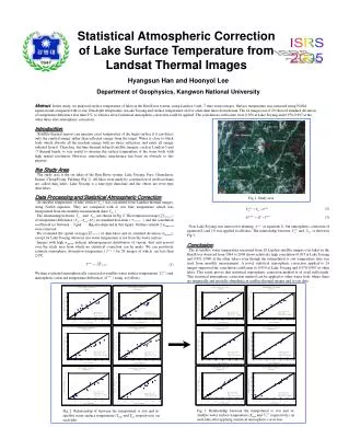
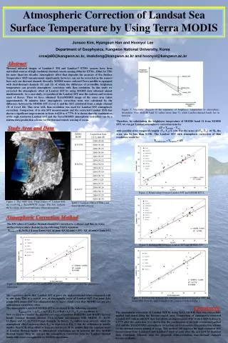
Atmospheric Correction of Landsat Sea Surface Temperature by Using Terra MODIS. Junsoo Kim, Hyangsun Han and Hoonyol Lee Department of Geophysics, Kangwon National University, Korea crowjs80@kangwon.ac.kr, imakdong@kangwon.ac.kr and hoonyol@kangwon.ac.kr. Abstract.

E N D
Atmospheric Correction of Landsat Sea Surface Temperature by Using Terra MODIS Junsoo Kim, Hyangsun Han and Hoonyol Lee Department of Geophysics, Kangwon National University, Korea crowjs80@kangwon.ac.kr, imakdong@kangwon.ac.kr and hoonyol@kangwon.ac.kr Abstract Thermal infrared images of Landsat-5 TM and Landsat-7 ETM+ sensors have been unrivalled sources of high resolution thermal remote sensing (60m for ETM+, 120m for TM) for more than two decades. Atmospheric effect that degrades the accuracy of Sea Surface Temperature (SST) measurement significantly, however, can not be corrected as the sensors have only one thermal channel. Recently, MODIS sensor onboard Terra satellite is equipped with dual-thermal channels (31 and 32) of which the difference of at-satellite brightness temperature can provide atmospheric correction with 1km resolution. In this study we corrected the atmospheric effect of Landsat SST by using MODIS data obtained almost simultaneously. As a case study, we produced the Landsat SST near the eastern and western coast of Korea. Then we have obtained Terra/MODIS image of the same area taken approximately 30 minutes later. Atmospheric correction term was calculated by the difference between the MODIS SST (Level 2) and the SST calculated from a single channel (31 of Level 1B). This term with 1km resolution was used for Landsat SST atmospheric correction. Comparison of in situ SST measurements and the corrected Landsat SSTs has shown a significant improvement in from 0.6229 to 0.7779. It is shown that the combination of the high resolution Landsat SST and the Terra/MODIS atmospheric correction can be a routine data production scheme for the thermal remote sensing of ocean. Figure 3. Schematic diagram of the responses of brightness temperature to atmospheric absorption. Note MODIS band 32 suffers more than 31, while Landsat thermal bands lies in between. Therefore, by substituting the brightness temperature of MODIS band 31 from MODIS SST, we can get Landsat atmospheric correction term by T = TMODIS – T31, with possible error ranges of roughly (T31-T32)/2 (>0). For the areas of (T31-T32) <0.7K, the error can be less than 0.35K. The Landsat SST with atmospheric correction of 1km resolution would be: TLandsat-atm = TLandsat + T. Study Area and Data Figure 4. Relationship between Landsat SST and MODIS BT31. Figure 1. The study area. Three frames of Landsat data are overlying a Terra/MODIS image. The dots indicate the locations of coastal stationary observation posts. Table 1. Landsat (TM or ETM+) and Terra MODIS dataset. Atmospheric Correction Method The DN values of Landsat thermal channel is converted to radiance and thus to water surface temperature (Kelvin) by the following NASA equation: TLandsat = K2/ln{K1/[(Lmax-Lmin)/(QCALmax -QCALmin)×(DN - QCALmin)+ Lmin]+1} Figure 5. Relationship between Landsat SST and MODIS SST. Figure 2. Relationship between Landsat SST and in-situ temperature before the atmospheric correction. The regression shows that Landsat SST is generally underestimated when compared with in situ data. This is a typical case of atmospheric error of Landsat SST. For some data points with minus SST was eliminated due to heavy cloud cover that MODIS can not give atmospheric correction either. The atmospheric-corrected MODIS SST is calculated by the following equation: TMODIS = a1 + a2T31 + a3×(T31-T32)×Bsst+ a4×(T31-T32)×(sec(theta)-1) Now we need to consider the spectral coverage of Landsat TM/ETM+ and MODIS thermal bands. Landsat thermal channel (10.4–12.5μm) encompasses both MODIS 31 (10.78-11.28μm) and 32 (11.77-12.27μm) channels. In theory, T32 suffers more severely when the atmospheric effect increases than T31, as depicted in Fig. 3, but the difference is usually smaller than 0.7K when cloud or haze are not severe. If we assume that the response trend of Landsat thermal bands to atmospheric absorption are in between the two MODIS thermal bands, then we can get the atmospheric correction term for Landsat thermal bands with errors recognizable by MODIS algorithms. Figure 6. Relationship between the atmospheric-corrected Landsat SST and in-situ SST. Note the improvement of R2 compared to that of Fig. 2. Conclusion The atmospheric correction of Landsat SST by using Terra MODIS data was successfully applied and tested along the Korean coastal area. Comparison of atmospheric-corrected Landsat SST with in situ SST data has shown an improvement of R2 from 0.6229 (before) to 0.7779 after the correction. It is shown that the combination of the high resolution Landsat SST and the Terra/MODIS atmospheric correction can be a routine data production scheme for the thermal remote sensing of ocean. This method will improve the high-resolution SST measurement from Landsat-5 and Landsat-7 until or even after the new LDCM (Landsat Data Continuity Mission) with the proposed 120m-resolution, dual-thermal channels become available.