Construction of a Rio Grande Schematic Model
120 likes | 250 Vues
This project focuses on developing a schematic water model for the Rio Grande to integrate agricultural, municipal, and reservoir water demands. The objective is to create a comprehensive representation that allows for better understanding and management of water resources. It includes data collection from various sources such as IBWC and TCEQ to analyze demands. Additionally, the model construction incorporates demand nodes, US irrigation districts, and streamgages. Future research aims to enhance the model's capabilities while acknowledging contributions from classmates and faculty.

Construction of a Rio Grande Schematic Model
E N D
Presentation Transcript
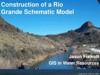
Construction of a Rio Grande Schematic Model Jason Fialkoff GIS in Water Resources Image Source: Team Ten, 2004
OUTLINE • Objective • Background • Data Collection • Model Construction • Future Research • Questions
OBJECTIVE To construct a Rio Grande schematic water model that encompasses agricultural, municipal, and reservoir demands.
BACKGROUND • Location • Prior research • Why do this?
DATA COLLECTION • Agricultural Demands (IBWC, TCEQ, CNA) • Municipal Demands (IBWC) • Reservoir Demands (IBWC, CNA)
MODEL CONSTRUCTION • Create Rio Grande schematic
MODEL CONSTRUCTION • Add Demand Nodes
MODEL CONSTRUCTION To Complete: • Add US Irrigation Districts and IBWC Stream Gages • Finish Linking Attribute Tables • Assign Flow Direction
OASIS ArcGIS Statdata.mdb NODE, ARC DATA COMBINED DATA SPATIAL COORDINATES FUTURE RESEARCH
ACKNOWLEDGMENTS • Carlos Patino • Cindy Green and Nishesh Mehta • Helpful Classmates • Dr. Maidment