Download
1 / 29
290 likes | 306 Vues
Explore the history of GIS, review different software options, learn about data collection and projection, and discover the functionalities and applications of GIS software. Includes detailed instructions for using ArcMap, ArcCatalog, ArcScene, and more.

E N D
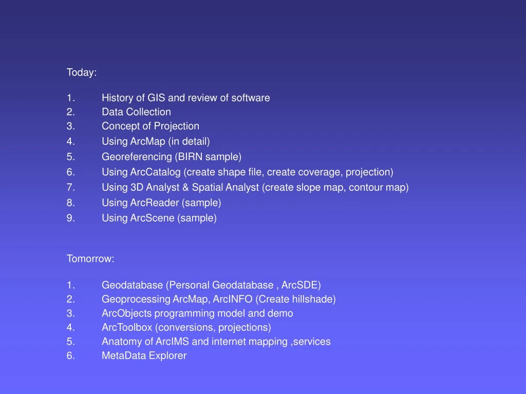
Today: • History of GIS and review of software • Data Collection • Concept of Projection • Using ArcMap (in detail) • Georeferencing (BIRN sample) • Using ArcCatalog (create shape file, create coverage, projection) • Using 3D Analyst & Spatial Analyst (create slope map, contour map) • Using ArcReader (sample) • Using ArcScene (sample) Tomorrow: • Geodatabase (Personal Geodatabase , ArcSDE) • Geoprocessing ArcMap, ArcINFO (Create hillshade) • ArcObjects programming model and demo • ArcToolbox (conversions, projections) • Anatomy of ArcIMS and internet mapping ,services • MetaData Explorer
GIS Software • The geoprocessing engines of GIS • Major functions • Collect, store, mange, query, analyze and present • Key terms • Program – collections of instructions to manipulate data • Package– integrated collection of programs • Component – self-contained, reusable software building blocks
Functionality Architecture User Interface Applications Geographic Tools Analysis Output Translation Customization Editing Display Data Manager Spatial Reference Data Access Vector Raster
Autodesk ESRI Intergraph MapInfo Smallworld Viewer AutoCAD LT ArcReader GeoMedia Viewer ProViewer Custom Desktop World ArcView GeoMedia MapInfo Professional Spatial Intelligence Profess-ional AutoCAD / Map ArcEditorArcInfo GeoMedia Pro MapInfo Professional Smallworld GIS Hand-held OnSite ArcPad IntelliWhere MapXtend Scout Database Server GIS Server ArcSDE Uses Oracle Spatial SpatialWare Part of Smallworld GIS Component In several products Map Objects Part of GeoMedia MapX, MapJ Part of Smallworld GIS Internet MapGuide ArcIMS GeoMedia Web Map, GeoMedia Web Enterprise MapXtreme, MapXSite Smallworld Internet Applic- ation Server CAD AutoCAD Map In several products In several products In several products Part of Smallworld GIS Product Families
GIS Software Classification Number of Users Cost Internet Viewer Component Hand-held Desktop Professional Functionality
ArcSDE Unifies Spatial Data Access • ArcGIS Desktop Applications • ArcIMS , ArcExplorer, ArcPad • MapObjects • Third-Party applications ArcSDE Services SQL Server Oracle Informix IBM DB2
Enterprise GIS Organizations expect to... • Leverage existing spatial data (eliminate silos) • Integrate spatial data with core business data • Incorporate spatial into workflow between departments (for a city…tax assessor, appraisal, DPW, police, fire, IT) • Deploy IT standards to all their data • Move client / server GIS apps to the web and wireless devices • Benefit from scalability and security
First, Spatially Enable The Data… Data Is Independent of Application ArcSDE ArcIMS ArcGIS SQL Server High Availability, High Performance, Secure, Scalable
PMF Publisher Authors PMF Documents ArcReader ArcMap Publisher MXD Data A New Extension
Distributed GIS • Consume and expose Web services for: • Mapping • Metadata • Data sharing and distribution • Geoprocessing • Provide standard services and components for web developer (.Net, “generic XML/SOAP”, or Java API’s)
GIS Internet Enterprise Today Applications Browsers Web Web Server Broker Databases
Future GIS Internet Enterprise Applications Browsers Web Broker Web Server Services Databases
Distributed GIS Development • New Concept – g.net architecture • leveraging emerging web technologies • Web services • GIS technology for applications over the web • Mapping • Metadata • GIS Functionality • Spatial Data sharing and distribution • Extends ArcGIS Systemconcept • Desktop Applications • Back Office Servers • Distributed “Services” via the Internet
GIS Portal GIS Portal GIS Portal G.net Architecture Building Blocks • Network architecture (Distributed) • Loosely Coupled • Internet Standards • Many GeoServices • Many Clients • Metadata Servers • Open / Interoperable • Full GIS capabilities GIS Users Connect and UseCheckout and Use Search Catalog and Find World Wide Web • Publish GIS Data & Services • Document in Catalog Metadata Server Author, Manage, Serve Catalogs Author, Manage, Serve Geographic Information Collections
ESRI Direction“Software for G.Net” ArcGIS Used to build • Data • Maps • Models • Applications • Metadata ArcIMS • Serve GIS • Data • Maps • Apps GIS Web Services Array of GIS Clients Access and use GIS data and services • ArcReader • Map Objects for Java • ArcGIS Desktop & Extensions • ArcPad ArcSDE Used to manage • Data • Metadata • Transactions ArcGIS • Author and Manage Metadata • Build Catalog Metadata & Catalog Services GIS Clients ArcIMS • Manage Metadata • Provide Search Services ArcSDE Used to manage and distribute • Metadata
Market Forces Are Driving Change • Organizations are moving and consolidating spatial data into relational databases to improve interoperability • Organizations are moving client/server mapping applications to the web and looking to web services for the future • Organizations are integrating spatial data analysis and map visualization into key business applications to improve decision making and service delivery
Data Collection • One of most expensive GIS activities • Many diverse sources • Two broad types of collection • Data capture (direct collection) • Data transfer
Primary Data Capture • Capture specifically for GIS use • Raster – remote sensing • e.g. SPOT and IKONOS satellites and aerial photography • Passive and active sensors • Resolution is key consideration • Spatial • Spectral • Temporal
Vector Primary Data Capture • Surveying • Locations of objects determines by angle and distance measurements from known locations • Uses expensive field equipment and crews • Most accurate method for large scale, small areas • GPS • Collection of satellites used to fix locations on Earth’s surface • Differential GPS used to improve accuracy
Secondary Geographic Data Capture • Data collected for other purposes can be converted for use in GIS • Raster conversion • Scanning of maps, aerial photographs, documents, etc • Important scanning parameters are spatial and spectral (bit depth) resolution
Vector Secondary Data Capture • Collection of vector objects from maps, photographs, plans, etc. • Digitizing • Manual (table) • Heads-up and vectorization • Photogrammetry – the science and technology of making measurements from photographs, etc. • COGO – Coordinate Geometry
Data Transfer • Many widely distributed sources of GI • Key catalogs include • US NSDI Clearinghouse network • Geography Network • Access technologies • Translation • Direct read
Federal Data Agencies • USGS • NOAA • Census Bureau • NIMA • EPA • many more...