Download
1 / 1
10 likes | 124 Vues
Nowcasting to Protect Public Water Supply: Using Real Time Data in an Emergency Flow and Transport Model Namsoo S. Suk, Ph.D., and John Yagecic, P.E. P.O. Box 7360, 25 State Police Dr.,, West Trenton, NJ 08628-0360, Phone: 609-883-9500 Fax: 609-883-9522 www.drbc.net.

E N D
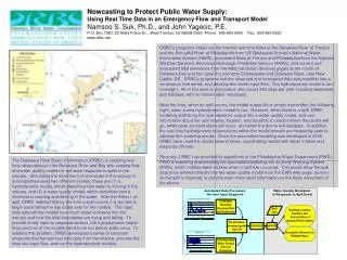
Nowcasting to Protect Public Water Supply: Using Real Time Data in an Emergency Flow and Transport Model Namsoo S. Suk, Ph.D., and John Yagecic, P.E. P.O. Box 7360, 25 State Police Dr.,, West Trenton, NJ 08628-0360, Phone: 609-883-9500 Fax: 609-883-9522 www.drbc.net DRBC's programs obtain via the internet real time flows at the Delaware River at Trenton and the Schuylkill River at Philadelphia from US Geological Survey's National Water Information System (NWIS), forecasted flows at Trenton and Philadelphia from the National Weather Service's Advanced Hydrologic Prediction Service (AHPS), and current and forecasted tidal elevations from the National Ocean Services gages at the mouth of Delaware Bay and the canal the connects Chesapeake and Delaware Bays, near New Castle, DE. DRBC's programs knit the observed and forecasted data sets together into a continuous time series, and develop the model input files. The hydrodynamic model is run overnight. All of this work is automated, and occurs 365 days per year including weekends and holidays, with no human labor necessary. Most the time, when no spill occurs, the model output file is simply overwritten the following night, when a new hydrodynamic model is run. However, when there is a spill, DRBC modeling staff bring the hydrodynamic output into a water quality model, and use information about the spill volume, location, and duration, to predict where the plume will go, when peak concentrations will occur, and when the plume will dissipate. In addition, the real time hydrodynamic observations within the model domain are frequently used to validate the modeling results. Since the automated modeling was developed in 2006, DRBC have used the model several times, coordinating results with water intakes and response officials. Recently, DRBC has provided its algorithms to the Philadelphia Water Department (PWD). PWD is exploring incorporating the automated modeling into its Early Warning System (EWS), which notifies water intakes when a spill has occurred. This would allow the spill data to be entered directly into the water quality model from the EWS web page, as soon as the spill is reported, to provide even more rapid information on the likely movement of the plume. The Delaware River Basin Commission (DRBC) is coupling real time observations in the Delaware River and Bay with existing flow and water quality models to enhance response to spills in the estuary. Simulating the movement of chemicals in the estuary is accomplished using two different models; these are (1) a hydrodynamic model, which describes how water is moving in the estuary, and (2) a water quality model, which describes how a chemical is reacting and diluting in the water. After the Athos I oil spill, DRBC realized that by the time a spill occurs, it is too late to begin assembling the input data sets for the models. The input data sets tell the models how much water is flowing into the estuary and how the tidal boundaries are rising and falling. To provide timely input to response actions, the hydrodynamic (water flow) portions of the models need to be run before spills occur. To address this problem, DRBC developed a series of computer programs that harvest real time data from the internet, process the data into input files, and run the hydrodynamic models.