Download
1 / 15
160 likes | 269 Vues
Explore how digital images composed of pixels can be manipulated and calibrated using remote sensing techniques. Learn about multi-spectral imaging, contrast and brightness levels, density slicing, and digital elevation models. Gain insights into visualizing and analyzing imagery data efficiently.

E N D
Applying Pixel Values to Digital Images Guilford County SciVis V202.02
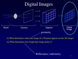
Digital Images Gather Data by Remote Sensing • Remote Sensing is the process of gathering information without touching it. • Satellites use a number of different sensors (IR, UV, Visible light, Radio) to record information
Digital Images Gather Data by Remote Sensing • Example of remote sensing include: • Microscopes and Telescopes • Echolocation • Infrared Radiation (Heat.. Heat sensors) • Sounds waves used in medical Imaging (MRI) • X-rays used to detect to detect broken bone
What are Digital Images? • Digital images are composed of pixels arranged in rows and columns. • Each pixel carries a numerical values or digital number (DN). • Colors or shade of gray (brightness) are assigned to each DN.
What are Digital Images? • A LUT (Look-Up table) is used to show the scale relationship between each pixel’s DN and its assigned color or gray brightness value. • Changing the LUT scale controls the appearance of the image.
What are Digital Images? • Digital data can be manipulated • Pseudocolors (false colors) can be assigned to an image using the LUT. • Uses would include: • Enhance weather images to see moisture, wind patterns, solar energy, etc. • Color coding Medical Images • Enhancing satellite images to see fire, glacier movement, forest depletion, etc.
Multi-spectral Remote Sensing • Recording energy in the red, green, blue, IR, UV, or other parts of the electromagnetic spectrum.
Multi-spectral Remote Sensing • Multi-spectral remote sensing measures the amount of energy reflected in bands that correspond to specific colors. • Scientists can obtain information from these wavelengths (color). • For example, scientists can pick out the range of color of marijuana plants grown.
Contrast and Brightness Levels • The BRIGHTNESS is the intensity of white in an image. • The CONTRAST or Value is the difference between the lightness and darkness of an image.
Measuring in Area Renderings • The portion of the earth is dependent on the height of the satellite. Most weather satellites use the scale of 16 square miles equals 1 pixel. Programs like Scion Image allow you to set these scales. • The curve of the earth may add variation to these renderings.
Histograms in Area Renderings • Histograms are displayed as a bar graph. The height of the bar displays the number of pixels.
Density Slicing • Density slicing allows you to highlight a range of pixel values in the LUT. • The highlighted pixels help visualize areas of interest.
Digital Elevation Models (DEM’s) • DEM’s are images where DN (digital number) or grayscale values represent elevation. • A digital image can be converted into a relief map.
Elevation Calibration (Calibrated DEM’s) • Take the data from a DEM to apply known elevation to calculate other elevations. • Mapping out the sea surface floor is an example of using this method.