Download
1 / 9
90 likes | 292 Vues
T ropospheric O zone L idar Net work ( TOLNet )- Long-term Tropospheric Ozone Profiling for Satellites, Modeling, and Chemistry Studies. NDACC Lidar Working Group Meeting , NASA/JPL, Table Mountain, CA, Nov. 7, 2013.

E N D
Tropospheric Ozone Lidar Network (TOLNet)- Long-term Tropospheric Ozone Profiling for Satellites, Modeling, and Chemistry Studies NDACC Lidar Working Group Meeting, NASA/JPL, Table Mountain, CA, Nov. 7, 2013 Mike Newchurch1, Raul Alvarez2, Jay Al-Saadi35, John Burris4, Wesley Cantrell1, Gao Chen5, Russell DeYoung5, Mike Hardesty2, Ray Hoff6, Guanyu Huang, Jack Kaye3, Kevin Knupp1, Alex Pszenny3, Shi Kuang1, Andy Langford2, Thierry Leblanc7, Stuart McDermid7, Tom McGee4, Brad Pierce8, ChristophSenff2, John Sullivan4, Jim Szykman9, Gail Tonnesen9, and Lihua Wang1 1UAHuntsville, 2NOAA/ESRL, 3NASA/HQ, 4NASA/GSFC, 5NASA/LaRC,6UMBC, 7NASA/JPL, 8NOAA/NESDIS,9USEPA, http://nsstc.uah.edu/atmchem/
GSFC TOLNet Motivation ESRL LaRC UAH JPL Motivedby the growing demand for high-temporal-resolution ozone measurements at multiple stations with a reasonable cost for air-quality studies, model input or evaluation, and satellite validation. GEO-CAPE/TEMPOwill measure tropospheric gases and aerosols at ~8km and hourly resolution. Vertical resolution is on the order of 5-10km in the troposphere. This vertical resolution is inadequate to resolve laminar structures that characterize tropospheric ozone and aerosols. Furthermore, GEO-CAPE information content in the PBL will likely be inadequate to resolve the processes responsible for air quality variability. We seek, therefore, to augment the spaceborne measurements with a ground-based measurement system. Ozonesondesare used extensively in various atmospheric chemistry studies because of their low upfront cost and well-characterized behavior. However, the whole process for a sonde launch typically requires four hours. And four-hour ozonesonde resolution is prohibitively expensive. We therefore consider lidars to provide the necessary spatial and temporal resolution.
TOLNet Objectives Provide high-resolution time-height measurementsof ozone and aerosols at a few sites from near surface to upper troposphere for air-quality/photochemical models and satellite retrieval validation; Support field campaigns and existing networks(e.g., DISCOVER-AQ, SOAS, SENEX, SEAC4RS) to advance understanding of processes controlling regional air quality and chemistry; Develop recommendationsfor lowering the cost and improving the robustness of such systems to better enable their possible use in future national networks to address the needs of NASA, NOAA, EPA and State/local AQ agencies. CMAQ SEAC4RS
NOAAMobile Ozone Lidar at Discover-AQ Houston The NOAA/ESRL mobile ozone lidar (TOPAZ) was deployed in Houston, TX from 29 August to 27 September 2013 in support of the NASA Discover-AQ campaign. TOPAZ was situated at the La Porte Airport next to the TCEQ met tower and wind profiler and a suite of O3 and NOx sensors operated by EPA. Time-height cross section of preliminary TOPAZ O3 observations on 25 September 2013. TCEQ met tower On 25 September, light winds and recirculation of pollutants by the sea breeze led to very high afternoon O3 concentrations. Titration of O3 in the shallow morning boundary layer was followed by a quick increase in O3 due to photochemical production. A rapid rise of the boundary layer around midday caused a temporary drop in O3 levels as cleaner air from aloft was mixed down. In the evening, the sea breeze brought in lower-O3 air in the first 300 m AGL, leaving a “dirty” residual layer aloft. TOPAZ lidar Instrumentation at the La Porte Airport site, shown during one of the many missed approaches by the NASA-P3B aircraft. EPA trailer The primary objective of the TOPAZ deployment was to characterize the horizontal and vertical distribution of O3 in the boundary layer in support of the Discover-AQ aircraft observations. TOPAZ measurements were also aimed at characterizing the O3 distribution during the morning and evening transition periods and to investigate the influence of the land sea breeze circulation. Preliminary TOPAZ data from the Discover-AQ Houston campaign can be accessed under http://www.esrl.noaa.gov/csd/groups/csd3/measurements/discoveraq/.
Table Mountain Facility Ozone Lidar JPL operates two DIAL systems at TMF for measurement of ozone profiles. To date, our emphasis has been free troposphere and stratosphere observations (NDACC) and signals from low altitudes, below 4 km are purposely blocked by a rotating shutter. Stratosphere-Troposphere Transport often results in high ozone plumes above the boundary layer but that sometimes mix to the surface. Simultaneous ozone and water vapor lidar observations at TMF can clearly identify stratospheric intrusions. This figure shows a plume of high ozone correlated with very low humidity, characteristic of a stratospheric intrusion. To measure the ozone profile in the near surface region currently not observed by our lidar, we have designed and built two near-field mini-receivers (one each for 289 and 299 nm). Two additional data acquisition channels have also been procured (photo right). Once operational we plan to validate the low altitude measurements using tethered ozone-sondes. We also plan to augment the profile observations with surface ozone measurements. The start of operations depends on the availability of filters, currently quoted at 12 weeks delivery. Anticipate operational by 6/2012. Preliminary tests indicate daytime operations will be possible. This figure shows an example of the current capability of the ozone lidars and an intercomparison with an ozone-sonde. http://www.ndacc.org http://tmf-lidar.jpl.nasa.gov 27 January 2012
NASA/GSFC Mobile Lidar Data acquisition system Raman cells Telescope Recent measurement example (O3 ppbv) View from inside the 40’ trailer. Moving from left to right: the rack for the data acquisition system; the optics module package that houses the narrow band interference filters for the PMT’s, the chopper attached to the telescope, which helps eliminate saturation of the PMT’s; the transmission platform for two 1’’ detectors is mounted directly next to the 18’’ telescope for the near-ground ozone measurements. The two 72’’ Raman cells mounted on the table produce 289 and 299-nm lasers using pressurized hydrogen and deuterium.
NASA/LaRC Mobile Lidar 1.Telescope 2. Fiber-optic 3. Nd:YLFLaser 4.Ce:LiCAF Laser 5.Detector Array 6.Controls and Power 7.Transmitter Optics 3 4 2 5 Mobile Ozone DIAL system in laboratory 6 1 NASA Langley is developing an ozone lidar in a trailer that can be easily deployed at locations throughout the U.S. The lidar will produce tunable on and off ozone DIAL laser wavelengths between 280 and 300 nm at 500 Hz each. There is also a 527 nm aerosol channel. The system has an in situ ozone measurement capability which will allow ozone to be profiled from the ground to the lower troposphere. 7
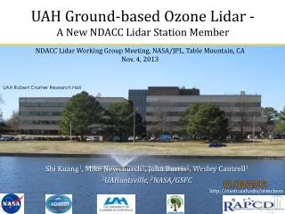
UAH Ground-based Ozone Lidar TheUAHuntsville O3 lidar system was developed jointly by UAHuntsville and NASA/GSFC [Kuang et al., 2011a]. (Left) Receiver system showing the recently added 1’’ mini receiver to measure ozone between 100 and 1000m altitude; (Right) Raman shifted YAG transmitter replacing previous dye lasers. Located at a 200-m ASL slightly polluted city, this lidar makes ozone retrieval from 0.1 to ~12 km during both daytime and nighttime with a typical integration time from 2 to 10 min. 1’’ receiver (Ch-0) 100m-1km 16’’ receiver (Ch-5) 3-12km 4’’ receiver (Ch-1 and Ch-2) 500m-1.5km, 1-5km Laser outgoing mirror Laser transmitter Receivers
3. Data Access GSFC ESRL LaRC http://www-air.larc.nasa.gov/missions/TOLNet/ UAH JPL The TOLNet ozone data are available to the scientific community through the NASA/LaRC websitewith the TOLNet format defined by the working group. The format manual and the IDL codes to write and read the data are provided on the website. Some stations (e.g., UAH, ESRL) also provide data in ICARTT format.