Fire Risk Mitigation Strategies in Strawberry Canyon: Analyzing Vegetation Management Effectiveness
The devastating 1991 Oakland Hills fire underscores the urgent need for effective vegetation management to mitigate fire risks in Strawberry Canyon. This project utilizes the FARSITE fire model to assess fire risk and evaluate the potential effectiveness of various vegetation treatments. By balancing costs, community impact, and fire risk reduction, we propose optimal solutions for managing fire-prone areas. Through sensitivity analysis and benefit-cost ratio assessments, our findings aim to inform decision-making for fire-risk reduction while considering aesthetic concerns and community preferences.

Fire Risk Mitigation Strategies in Strawberry Canyon: Analyzing Vegetation Management Effectiveness
E N D
Presentation Transcript
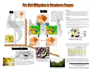
Fire Risk Mitigation in Strawberry Canyon Problem The 1991 Oakland Hills fire has drawn attention to the necessity for active vegetation management to reduce fire risk. UC Berkeley faces the challenge of managing large areas of fire-prone land in Strawberry Canyon. The administration acknowledges the need for fire-risk reduction measures in Strawberry Canyon as a means to protect adjacent communities and maintain ecological health. However, high treatment costs and public aesthetic preferences limit the options of the vegetation managers in their efforts to reduce this risk. This project uses the FARSITE fire model to assess risk in Strawberry Canyon and to determine the effectiveness of possible vegetation treatments. We propose a model that analyzes which treatments, or combination of treatments, best reduce risk and minimize cost and aesthetic impact. The model was run with available data from Strawberry Canyon Solution Vegetation manipulations were chosen by conducting initial runs of FARSITE on the non-manipulated vegetation coverage. An algorithm, based on fire line intensity and crowning, was used as a metric for fire risk. Thresholds of the algorithm were used to assign manipulations, in which certain polygons had their fuel model number lowered. Manipulations were divided into those with and without a defensible fuel profile zone. All manipulated coverages were run in FARSITE to determine if risk was reduced. Cost of treatment per manipulated polygon was then analyzed, factoring in distance to nearest road and slope. The number of households that can see each manipulated polygon was also recorded as an attribute. The optimal solution seeks to minimize cost, community impact and fire risk. We identified the best manipulations through graphical means and through cost-benefit analysis. We also used a sensititivity analysis to see how results would change as community preferences change. Graphical method Looking at the three-dimensional graphical relationship between standardized values of fire risk, cost and community opinionso that all three variables have comparable units with ranges from 0-100. Those treatments that are located above the fire risk/cost diagonal are considered sub-optimal. Benefit-Cost and Sensitivity Analysis Method A benefit to cost ratio was constructed for each manipulation, using normalized values for risk reduction benefit, treatment cost and social cost (aesthetic impact). Since the “social cost,”or negative social perception, of vegetation removal in Strawberry Canyon is not known, we did a sensitivity analysis, to see how the outcome of best benefit to cost ratio changed as the “social cost” increased. We can see trends for the same type of vegetation manipulation with higher social costs lower the Benefit / Cost ratio. The two most optimal of our 14 manipulations are outlined in yellow. Both involve moderate vegetative management in the upper and mid portions of the canyon (the treated polygons for each are shown to the left, as the blue polygons). Denfensible Fuel Profile Zones, both along the ridgeline and across the canyon mouth, were found to be ineffective in relation to their high cost. A ridgeline DFPZ is not needed because, in our simulations, fire tended to travel down-canyon, and not over the ridge. The canyon-mouth DFPZ was not effective in stopping fires (due to spotting) unless there was also considerable up-canyon management. Overall, the best solution appears to be to manage the stands of brush and grass in the upper canyon, and do some limited management of trees in that area. Fire Risk Cost Using FARSITE we assessed fire risk in Strawberry Canyon and suggested manipulations of stands based on that analysis. In order to determine which stands to manipulate, a risk algorithm was generated from the initial runs. For each manipulation, different polygons over a certain threshold value were treated. Stands were manipulated by reducing the FARSITE fuel model and then simulations were run and outputs analyzed for fire risk. • Manipulation costs factor in the type of manipulation, the average slope for the vegetation management polygon and the distance to the nearest road. Costs were calculated on each of the 14 manipulation coverages. Costs were determined by multiplying the polygon acreage by treatment costs for all management polygons and then summing for the entire coverage. Algorithm (lower threshold) Algorithm (higher threshold) Decision Rule Manipulation Risk Analysis Community Opinion Without comprehensive survey data it impossible to gauge local residents' opinions towards a DFPZ and/or vegetative management in Strawberry Canyon. While we do not possess those data, we were able to come up with a framework to analyze community opinion. To do this, we have determined how viewable each management unit is from surrounding neighborhoods. Those areas with high “viewability” are weighted more heavily in considering community opinion, while those with less “viewability” are weighted less. We chose to conduct a visibility analysis that gives the user the option of whether to look at individual neighborhoods or to aggregate, because it is not clear at this point to what extent different community areas are concerned about vegetation management in Strawberry Canyon. Two possible defensible fuel profile zones (DFPZs) for the Protection of Panoramic/Dwight Community and Claremont Canyon Consultants: Austin Troy, David Ganz, Mu Lan, and Tao Duan Http://www.ced.berkeley.edu/la221/people/la221-ay University of California, Berkeley Prepared for LA221: Quantitative Methods in Environmental Planning (Instructor: Dr. John Radke GSI: James Scarborough Spring/98) A view up Strawberry Canyon