MACOORA Structure and Governance
610 likes | 771 Vues
NOAA IOOS Program Office Regional Status Assessment for the Mid-Atlantic Coastal Ocean Observing Regional Association (MACOORA). MACOORA Structure and Governance. MACOORA leadership Carolyn Thoroughgood, Board Chair Ed Kelly, Board Vice Chair Larry Atkinson, Board Secretary

MACOORA Structure and Governance
E N D
Presentation Transcript
NOAA IOOS Program OfficeRegional Status Assessment for theMid-Atlantic Coastal Ocean Observing Regional Association (MACOORA)
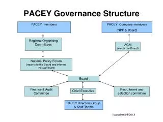
MACOORA Structure and Governance • MACOORA leadership • Carolyn Thoroughgood, Board Chair • Ed Kelly, Board Vice Chair • Larry Atkinson, Board Secretary • Jay Titlow, Board Treasurer • Dave Chapman, Executive Director • Board sets policy; Executive Director carries out MACOORA’s goal and policies • Organizational structure - 501(c)(3) incorporated Dec 2005; By-Laws; Business Plan
MACOORA Structure and Governance • Board membership • 12 to 15 Directors • All five sub-regions select a Director; seven At-Large Directors elected by MACOORA Membership; up to three additional Directors selected by Board • Industry, NGO, and Academic representation • Maritime, Water Quality, Energy, Fishing • Board meets in person 2X per year, by teleconference as needed, focusing on policy, goals, and guidance
Stakeholder Engagement • Key stakeholder groups or individuals • Maritime Safety • USCG,NOAA HAZMAT,NOAA NWS Surf Zone Forecasters • Ecological Decision Support • Fisheries Groups-Commercial, Recreational, Management • Water Quality • EPA, State Environmental Agencies, County Health Agents, & Municipal Governments • Types and frequency of engagement (workshops, regular mtgs, etc.) • Annual Meeting (October) • User needs workshops • Sub-regional meetings
Stakeholder Engagement • Key issues of importance to regional stakeholders, and how the RA addresses them? • Inundation • Maritime Safety • Ecological Decision Support • Water Quality
Stakeholder Engagement • Quantifiable, tangible expressions of support from stakeholders • Specific examples that demonstrate benefit of the RA to the region • Other stakeholders?
Stakeholder Engagement • MARCOOS observational data and models might enhance the predictions by the USCG’s Search And Rescue Optimal Planning System (SAROPS) - USCG • [MARCOOS] has the potential to provide significantly more accurate and detailed analyses and forecasts of [winds and currents]. – NWS • Your proposal to provide statistical regional surface current forecasts would be particularly supportive of our climate research as well as of our mission to promote sustainable fisheries. – NMFS • The maritime security element of [MARCOOS] will be beneficial to Connecticut from the standpoint of search and rescue and especially oil spill response. – CT DEP
Stakeholder Engagement • We are very interested in the inundation modeling and management tools that your [MARCOOS] will support. - MD EMA • A [MARCOOS] forecasting model based on an understanding of the hydrodynamics of bacteria in the environment will reduce the present time-lag in the assessment of human health risks. – MC(NJ) DofH • We are very excited at the prospect of having access to 3-D mapping of surface and subsurface ocean temperatures in the Mid-Atlantic, and for the enhanced marine safety that [MARCOOS] addresses. – Rec. Fishing Assoc. • [MARCOOS] information helps the fleet target the proper areas, reduces search time, reduces fuel costs and increases efficiency. It also helps us target the proper species of fish. – Atlantic Frost Seafood
Stakeholder Engagement Example • Right whales avoidance issue addressed at CBOS user forum • Discussion led by Maritime Association with talks by VA Port Authority, NMFS and Navy. • Outcome is more action by NMFS with maritime community. David Cottingham, NOAA/NMFS Heather Mantz, VA Port Authority David White, VA Maritime Assoc Donald Schrerardus, Deputy Asst. Sec. of the Navy for the Environment
Stakeholder Engagement – Recreational Fishing The Recreational Fishing Community (RFC) needs and wants more information for safer and more productive ocean trips. Some of this data exists but is not easily available to the user.We need to find ways to make research easier to find, use, and incorporate into the lives of fishing stakeholders. Information needs include: -localized real time weather -real-time sea conditions -sub-surface temps -enhanced sea temp data -offshore VHF broadcasts -coordination between Governmental and institutional entities for comprehensive sharing of observing resources
Current Activities and Funding • A summary of key activities in the region that are related to or support IOOS, including those not funded by NOAA IOOS • Interaction/joint work with other federal agencies • How can NOAA IOOS best support you in engaging other Federal agencies?
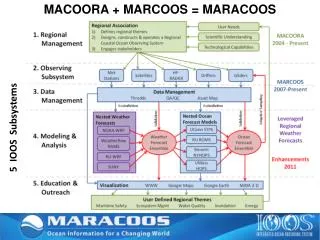
NWS WFOs Std Radar Sites Mesonet Stations LR HF Radar Sites Glider AUV Tracks USCG SLDMB Tracks NDBC Offshore Platforms CODAR Daily Average Currents MACOORA’s Regional Coastal Ocean Observing System (RCOOS) • Mid-Atlantic Regional Coastal Ocean Observing System (MARCOOS) • October 1, 2007 Start • Year 1: Request: $2.0 M Awarded: $1.7 M • Year 2: Request: $3.5 M Awarded: $1.7 M • Year 3: Request: $3.5 M • http://www.marcoos.us
MARCOOS – 30 PI’s, 20 Institutions, 2 Regional Themes, 2 Support Themes • Regional Theme 1 – Maritime Safety – Search And Rescue • Regional Theme 2 – Ecological Decision Support – Fisheries • Regional Support for Water Quality • Regional Support for Coastal Inundation
MARCOOS – 10 Major Tasks • Improved weather data and forecasts • HF Radar Network Operations • HF Radar QA/QC & Products • Autonomous Glider Operations • Satellite Data Acquisition • Statistical Short Term Prediction System • Ensemble of Dynamical Forecasts • DMAC • Education and Outreach • Economic Impact 6 Month Progress Report Submitted All Tasks on Track.
MARCOOS – Economic Impact • Year 1 Focus: Value of MARCOOS Output in Fisheries • Document and evaluate historical fishery science/management uses and current user needs for MARCOOS work products. • Develop strategies to match user needs with value-added MARCOOS products • Prepare articles, papers, and presentations that convey research results and provide recommendations for maximizing fishery values of MARCOOS
MARCOOS – Search And Rescue MAB HF Radar surface currents and Weatherflow winds used in a SAROPS test case. Selecting HF Radar data in SAROPS
Chesapeake Bay Observing System (CBOS) Chesapeake Inundation Prediction System(CIPS)
Elizabeth Smith, CBOS Executive Director, ODU Peter Ahnert, NOAA National Weather Service MARFC John Billet, NOAA National Weather Service, Wakefield, VA Bill Boicourt, UMCES Dennis King, UMCES Mike Koterba, USGS James Lee, NOAA, National Weather Service, Sterling, VA Ming Li, UMCES David Manning,NOAA National Weather Service, Sterling, VA Mark Penn, City of Alexandria, Alexandria, VA Kevin Sellner, CRC Tony Siebers, NOAA National Weather Service, Wakefield, VA Wade Smith, Noblis, Inc. Barry Stamey, Noblis, Inc. Gary Szatkowski, NOAA National Weather Service, Mt. Holly, NJ Jay Titlow, Weatherflow, Inc. Harry Wang, VIMS Doug Wilson,NOAA Chesapeake Bay Office The Cast
MOTIVATION: NOAA Storm Surge User Needs Assessment [Jan 2006] MACOORA Inundation Workshop [Nov 2006]Principal Findings: • Modeling Improvement:Wave set-up, rainfall/river outflows, increase vertical precision (+/- 1 ft), uniform national grid, expand to inland bays, expand extratropical forecasts, additional sensors to baseline and validate, probabilistic data runs for forecast uncertainty • Decision-Support Tools:Integrate data from several models, extend forecast to 48 hours before landfall, resolve issues on vertical datums, display surge as GIS/aerial photo/satellite image, need info on social and economic impacts, deliver on street-level detail. • Communication:NWS Forecast Offices communicate effectively, users are unaware of services, need increased agency collaboration, graphs and text are less effective, land use and coastal development need this, emergency/evacuation needs this • Outreach/Training:Need visualization tools, need impact information, educate policy makers about forecast uncertainties, need localized training, increase outreach to planners
VALUATION VISUALIZATION VALIDATION OBSERVATIONS HYDRODYNAMIC MODELING FORECAST Emergency Management OUTREACH Sea Level Rise ATMOSPHERIC MODELING Structural Mitigation CIPS Storyboard 2007-2010 Tsunami Planning? LIDAR Natural Resources Environmental Quality
Ensemble Approach • 4 Atmospheric Models—larger-scale models providing context for 2 high-res models: WRF and RAMS • 2 Hydrodynamic Models—ELCIRC, ROMS • 6 BC’s • 2 x 6 = 12 Atmospheric Forecast Runs x 2 Storm Surge Models = 24 = Ensemble • First: Hindcast Cases for Selected Sites • Alexandria, VA • Talbot/Dorchester County, MD • Norfolk, VA • Selected Storms: • Hurricane Isabel • Tropical Storm Ernesto • Northeaster, November 2006
Immediate Focus • Common grid output from both hydrodynamic models to begin visualization process, • Availability of LIDAR data in all areas • Visualization of the wind fields? How and how often and spatial resolution, • Determining the product for the EMs, elected officials, and citizens, e.g. WebEOC, EMMA • Integration into existing communication and decision making systems
Current Activities – New York Bight: Maritime Safety Partners and Collaborators Partners and Collaborators Funding Agencies
Current Activities – Delaware BayNWQMN Pilot Study • Riverine, estuarine and coastal • Resource management components: • Watersheds • Estuaries • Coastal/Ocean • Beaches • Wetlands • Groundwater • Atmosphere • Partners/leveraging
Current Activities – MARIBS • MIT Sea Grant project investigates transient tidal eddy motion east of Cape Cod and into the Great South Channel • Combines MARCOOS CODAR-derived surface current maps, shipboard/AUV water property & velocity measurements with ocean modeling • Surface drifter measurements and UCONN-developed STPS are used to assess regional CODAR measurement uncertainty • Future investigations will focus on how this eddy phenomena affects regional scallop fisheries recruitment
Current Activities and Funding Key activities in the region that are related to or support IOOS, including those not funded by NOAA IOOS • NOAA PORTS - Maritime safety • NDBC - Buoys • NWS – Marine forecasts; Coastal inundation watches and warnings • NMFS - Fisheries • NERRS - Stream gages • Sea Grant – Research, education, and outreach • MMS - offshore wind power activities • CG - SAROPS application
Current Activities and Funding key activities in the region that are related to or support IOOS, including those not funded by NOAA IOOS • Martha’s Vineyard Coastal Observatory • Ocean Observation Laboratory (OCEANOL) • Long Island Sound Coastal Observatory (LISICOS) • Monitoring Your Sound (MYSOUND) • Marine Sciences Research Center (MSRC) • New York Harbor Observing & Prediction System (NYHOPS) • New Jersey Coastal Monitoring Network (CMN) • Stevens Storm Surge Warning System (SSWS)
Current Activities and Funding key activities in the region that are related to or support IOOS, including those not funded by NOAA IOOS • Rutgers University Coastal Ocean Observation Lab (COOL) • Delaware Bay Observing System (DBOS) • Chesapeake Bay Observing System (CBOS) • Virginia Estuarine & Coastal Observing System • Center for Coastal Physical Oceanography (CCPO) • WeatherFlow, Inc.
Current Activities and Funding • Sources of funding • NOAA IOOS and other NOAA funds • Other Federal • Non-Federal • RA plans/efforts to match IOOS dollars with funding from other sources • What sources, and in what areas of work? • How can the NOAA Program Office help?
RA Coordination:Cooperative Agreements • As we reach the end of the first set of RA coordination grants, provide a summary of overall progress • Milestones and status • Updates to the RA progress reports • Any new information? • How are you doing?
RA Coordination:Cooperative Agreements • Milestones and status • Approved By-Laws • Elected Board of Directors • Incorporated Dec 2005 as 501(c)(3) • Obtained tax-free status • Held 3rd Annual Meeting Oct 2007 • Approved Business Plan • Submitted Concept of Operations document
RA Coordination:Cooperative Agreements • Updates to the RA progress reports • Sponsored CBOS Sub-regional User’s Forum (December 2007, Norfolk) OCEAN OBSERVATIONS TO IMPROVE DECISION- MAKING • Marine Weather Forecasting, Storm-tide and Inundation in Chesapeake Bay • Ocean Observing and Safer, More Efficient Maritime Operations: Northern Right Whale Ship Strikes • Observing Systems for Education, Recreation and Water Quality Monitoring
RA Coordination:Cooperative Agreements • Updates to the RA progress reports • Water Quality Monitoring: Managers’ Needs Assessment Workshop for Estuarine, Coastal, and Ocean Observations (Philadelphia, March 2008) • User Needs and Requirements • Public Health • Hypoxia/Algal Blooms • Habitat Loss and Freshwater Requirements • Needs versus Current Capabilities (Gap Analysis) • Filling the Gaps: Identifying opportunities and solutions
RA Coordination:Cooperative Agreements • Updates to the RA progress reports • Convened MARCOOS PI Meeting (Fall River, March 2008) • Initial six month progress assessment
RA Coordination:Cooperative Agreements • Updates to the RA progress reports • Continuing to survey Coastal Ocean Observing Assets in The Mid-Atlantic Region
RA Coordination:Cooperative Agreements • What will change with the new RA grant in FY08? • Strengthen MACOORA organizational structure • Establish formal User Council • Establish formal Science Council • Establish formal Education and Outreach Council • Organize Sub-region implementation group • Retain workshops (stakeholder engagement) in year 1, but without travel support for attendees
RA Coordination:Cooperative Agreements • What will change with the new RA grant in FY08? • Migrate to more outreach in years 2 and 3, focusing on interactions among MACOORA’s broad and diverse user community • Coordinate the demonstration and assessment of products emanating from the observing system • Consider Memorandums of Agreement with ocean observation providers to strengthen connection with MACOORA observation network • Revamp website
RA Coordination:Cooperative Agreements • New directions, partners, etc.? • Address energy theme (in addition to maritime safety, ecological decision-making, coastal inundation, and water quality) • Seek large corporate collaboration(s)
RA Future Development • RA views on function and performance metrics • How can we best measure outputs and outcomes? • Need guiding set of goals we all understand • HF Radar national network • National Water Quality Monitoring Network • Coordination of modeling efforts - how to knit together • For CODAR, report percentage of “up” time
RA Future Development • Objectives of the RA and plans for the near-term FY08-12 • Establish formal User Council • Establish formal Science Council • Establish formal Education and Outreach Council • Organize Sub-region implementation group • Plan Sub-regional stakeholder meetings • Plan Regional strategy meeting • Plan Promotional activity
RA Future Development Summary of top five priorities for development of RCOOS capabilities with cost estimates • Enhance MACOORA: $3M/yr • Data Management ($1 M) • Education & Outreach ($1 M) • Economic Impact studies ($1M) • Build out current MARCOOS (Maritime Safety and Ecological Decision-making) at original budget: $3.5M/yr • Enhance MARCOOS to address additional regional priorities (Coastal Inundation and Water Quality): $3.5M/yr
RA Future Development Summary of top five priorities for development of RCOOS capabilities with cost estimates • Enhance MARCOOS to sustain sub-regional components of regional network: $2M per sub-region = $10M/yr • Enhance "National Backbone“: $3M/yr Providing operational funding for: • PORTS within region ($1M - 5 @ $200K) • NDBC (New Buoys – Hudson Canyon; Ambrose, Chesapeake)($1 M) • Weather Research & Forecasting Models (WRF) @ WFO’s (5 x $200 K = $1M)
RA Views on Regional and National IOOS • RA needs with regard to the integration of regional and national planning efforts • MACOORA is very supportive of national planning for an integrated, distributed ocean observation system • RA expectations for development of the “national backbone” of observations • In situ, remote sensing, and data management and communications (DMAC) capabilities • Coordination of “national backbone” activities with regional and sub-regional ocean observing activities
RA Views on Regional and National IOOS RA expectations for development of the “national backbone” of observations • PORTS operational funding • Narragansett Bay • New Haven • New York – New Jersey • Delaware River and Bay • Chesapeake Bay • NDBC (New Buoys – Hudson Canyon; Ambrose, Chesapeake) • WRF @ WFO’s
Sub-regions connect to state and local organizations For example CBOS interacts closely with state agencies, NGO’s, and the large Bay programs (EPA) at a granularity that cannot be achieved regionally
Cross-regional Coordination • Discuss existing and potential coordination with other IOOS RAs • On regional efforts/issues? • On a national scale?