Download
1 / 18
180 likes | 321 Vues
Prospects for Using Historical Transmissometer Data in Large-Scale Assessment of Particular Organic Carbon. A.V. Mishonov, W.D. Gardner, & M.J. Richardson Department of Oceanography, Texas A & M University, College Station, TX, USA, 77843. Data Set.

E N D
Prospects for Using Historical Transmissometer Data in Large-Scale Assessment of Particular Organic Carbon A.V. Mishonov, W.D. Gardner, & M.J. Richardson Department of Oceanography, Texas A & M University, College Station, TX, USA, 77843.
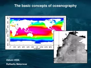
Data Set • Transmissometer data have been collected using instruments provided by our group over the last decade in collaboration with WOCE, JGOFS, and other large-scale hydrographic programs. • These data include basin-wide transects in the North and South Atlantic, North and South Pacific, Indian, and Southern Oceans. • We have proposed to analyze these data and convert the beam attenuation values to POC using the beam attenuation:POC relationships derived by our group during JGOFS Process studies.
Approach • Stramski et al. (1999, Science, 285: 239-242) have introduced algorithms to estimate POC from satellite backscatter data for the Southern Ocean for both surface values and euphotic zone integrations. • In a similar manner, our basin-wide data will be compared with satellite backscattering data on appropriate seasonal and space scales to establish region-specific algorithms. • A compilation of historic hydrographic/optical data has been compared by season with recent satellite data by Mishonov et al. (1999, IUGG-99, Vol. B., p. 242) and the results further validate our proposed global synthesis of POC in Case I waters (non-coastal) using satellite-derived data.
Dominant Wavelength Secchi Disk Calculated by regression Sep’98 Chlorophyll-a Forele-Ule Scale Data from Comparison of SeaWiFS & in-situ Sampling Data: 37th cruise of RV Academician Vernadsky,Aug - Sep 1988 SeaWiFS chlorophyll Sep’98
Dominant Wavelength Secchi Disk Chlorophyll-a SeaWiFS chlorophyll Forele-Ule Scale Data from Feb’98 Feb’98 Comparison of SeaWiFS & in-situ Sampling Data: 41st cruise ofRV Academician Vernadsky,Feb - May 1990
Initial Data Set • 15 cruises from February 1992 till June 1997; • 2027 Stations in Pacific, Indian and Atlantic oceans; • 1817 Transmissometer Casts; • Accompanied hydrological data on Temperature, Salinity and Dissolved Oxygen; • More data will be added from JGOFS, SAVE, WOCE, etc. legs.
Loaded Not loaded Station Coverage: WOCE, JGOFS & other data
Transmissometer Data Set Monthly Distribution
Pacific Ocean SectionTh.Thompson, Jul-Aug.93, p14n line Beam Attenuation South North Depth, m Distance, nm
Data from Pacific Ocean SectionTh.Thompson, Jul-Aug.93, p14n line Upper 500 meters Stations Position S, p.s.u. Temperature AVHRR SST July 1993 Salinity t, °C
Data from Pacific Ocean SectionTh.Thompson, Jul-Aug.93, p14n line Upper 500 meters Stations Position C m-1 Density SeaWiFS CHL July 1998 Beam Attenuation Kg/m3
Indian Ocean Section Knorr, Feb. 95, i09s line S N Stations Position Depth, m Beam Attenuation Distance, nm
Data from Indian Ocean Section Knorr, Feb. 95, i09s line Upper 500 meters North Stations Position Temperature Salinity AVHRR SST Feb 1995 t, °C S, p.s.u.
Data from Indian Ocean Section Knorr, Feb. 95, i09s line Upper 500 meters North Stations Position Density Beam Attenuation SeaWiFS CHL Feb, 1998 C m-1 Kg/m3
Future plans: 1 • Transmissometer database: • Process 17 WOCE cruises of transmissometer data; • Add processed transmissometer & POC data from 19 JGOFS cruises; • Add processed transmissometer data from other basin-scale cruises where we have data (9+). • Beam attenuation / POC relationship: • Use algorithms developed during JGOFS, NABE, EqPAC, Indian Ocean and Southern Ocean expeditions;
Future plans: 2 • Compile SeaWiFS back-scatter data for comparable times of POC + Beam attenuation measurements; • Refine algorithms for predicting POC from SeaWiFS data; • Examine hydrography of each area: • Mixed layer depth; • Subsurface maxima. • Correlate POC standing stock by ocean basin & season; • Analyse data in context of JGOFS Synthesis & Modelling Program.