Upper Level Ridge & Breakdown
This comprehensive overview examines essential fire weather patterns in Alaska, focusing on the Upper Level Ridge and its breakdown, which leads to increased lightning ignitions and dry fuels. It explores the Southerly Flow (Chinook) that brings strong winds and dry conditions, as well as the Northerly Winds that create cool, dry air despite lower temperatures. Additionally, it discusses Backdoor Precip and Southwesterly Flow's role in ending fire season through significant moisture. Understanding these patterns is crucial for fire management and prevention in this unique region.

Upper Level Ridge & Breakdown
E N D
Presentation Transcript
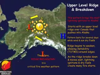
Upper Level Ridge & Breakdown • This pattern brings the most lightning ignitions to Alaska! L • Starts with an upper level ridge over Canada that pushes into Alaska H • Pattern lasts for several days while wind & sun dry fuels • Ridge begins to weaken, allowing instability (TSTMS) around edges. L • Therefore, • RIDGE BREAKDOWN • is a • critical fire weather pattern • As the ridge breaks down & moves east, lightning ignitions & dry fuels create many fire starts.
Upper Level Ridge & Breakdown H • This is how the 500 mb chart will appear for this pattern. L
Southerly Flow (Chinook) • This pattern brings dry conditions and strong winds to the north side of Alaska’s many mountain ranges! L • High pressure builds in directly from south • This creates: • - Strong winds (Chinook) • - Rain along coast • - Dry fuels on the north sides of mountain ranges • Therefore, • Southerly Flow • is a • critical fire weather pattern • Any ignitions will have rapid development due to winds and dry fuels. H
Southerly Flow (Chinook) • This is how the 500 mb chart will appear for this pattern. H
Northerly Winds • This pattern brings cool,dry winds to all of Alaska, drying fuels despite colder temperatures! L H • High pressure builds to west and low pressure over Canada May also occur if high shifts to north and low to south • Either pattern creates: • - Dry winds from north • - Clear skies • - Low temperature & RH • Therefore, • Northerly Flow • can be a • critical fire weather pattern With strong winds, this can increase fire danger across much of the state.
Northerly Winds L • This is how the 500 mb chart may appear for this pattern. H • This is an alternative appearance for the 500 mbchart for this pattern.
Backdoor Precip This pattern may bring significant amounts of rain to the Eastern and Central Interior…or not! There is a well-stacked closed low near Yakutat. The low moves north, often repositioning in the Copper River Basin • Southeast flow comes from Gulf of AK, through Canada L This brings rain into the upper Tanana and Yukon Valleys, dousing local fires. • Therefore, • Backdoor Precip • can be a • season-slowing event • Extent of precipitation is difficult to predict.
Backdoor Precip • This is how the 500 mb chart will appear for this pattern. L
Southwesterly Flow Wettest pattern for most of Alaska, this flow signals the end of our fire season. A flat ridge of high pressure builds into the Gulf of AK • The upper level flow brings in moisture parallel to the Alaska Range. • This brings clouds & rain into the dry interior, even to the ALCAN border. H Extensive moisture extinguishes most fires. • Therefore, • Southwesterly Flow • can be a • season-ending event Copper River Basin may be protected: takes longer duration to douse fires.
Southwesterly Flow • This is how the 500 mb chart will appear for this pattern. H