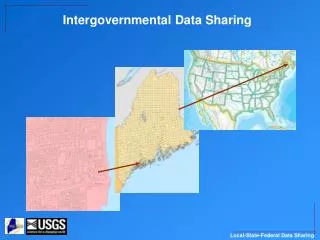
Intergovernmental Data Sharing
Intergovernmental data sharing is crucial for towns and counties to align local data with federal resources, like census data, enhancing analysis capabilities. By collaborating with MEGIS, municipalities can synchronize data and participate in funding opportunities from agencies such as USGS, EPA, and FEMA. Key partnerships include efforts to correct census boundaries and improve hydrographic datasets. Towns are encouraged to review data and participate actively in maintaining accurate regional records for better access to state and federal funds.

Intergovernmental Data Sharing
E N D
Presentation Transcript
Why bother? Just a lot of extra work, right? • In most cases, not really very much work at all – just sharing data with MEGIS, who will then share with feds. • Benefits to towns/counties include that federal data (census data for example) will align with state and local data – makes analysis easier for all of us. • Funding possibilities – Federal and state funds often available to bring local data in synch with state and federal data. • Funding for data sharing: • USGS funding for aerial photos, lidar, hydrographic data • EPA funding for watersheds • FEMA funding for lidar • State funding for parcel digitization Inconsistent town boundaries between MEGIS (red) and 2000 Census
Local – State – Federal data frameworks • Federal level is the National Spatial Data Infrastructure (NSDI) • State level is the Maine Geospatial Architecture (MGA), data section • Local is the business needs of municipalities and counties • NSDI Framework Themes: • Geodetic Control • Cadastral • Orthoimagery • Elevation • Hydrography • Administrative Units • Transportation • MGA Core Spatial Data: • All of NSDI, plus • Structures • Addresses • Emergency Response • Geographic Names • State Regulatory Data • Landcover/Imperviousness • Typical municipal data: • All of MGA, plus • Detailed cadastral data: parcels, zoning, planning • Assessors data • County deeds data • Detailed infrastructure
Partnership Opportunity #1 – US Census Boundary & Annexation Survey (BAS) • Goal is to synchronize Census maps with local town boundaries and roads, for delineation of 2010 census blocks and resulting data products. • Census Bureau sends maps to towns/counties for town boundary review. • MEGIS is state-level collection point for town boundary updates in GIS. • MEGIS feeds updated statewide town boundary layer to Census. • MEGIS feeds most current E911 roads data to Census. BAS is meant to correct this issue • How to participate: • Towns should receive BAS letters from Census • Review town boundary, report any changes to MEGIS as instructed in the letter • Ignore roads on the map, Census will use E911 for final product • MEGIS will incorporate boundary changes where both towns agree, but we will not get in the middle of a boundary dispute NSDI Framework Layer #5 – governmental units
Partnership Opportunity #2 – National Hydrography Dataset (NHD) and Water Boundary Dataset (WBD) • NHD originally developed with 1:100K scale data, useful at national scale but certainly not for towns. • NHD ported to 1:24K scale data for Maine in recent year, much better for the local picture, but still not suitable for all. • NHD now can utilize ‘local resolution’ which is basically 1:5K-1:10K or similar local resolution. • Watershed Boundaries are now part of NHD and can be updated • How to participate: • NHD stewardship is guided by a state MOA with USGS. Three individuals oversee all additions/modifications. • Municipalities/Counties that have better hydrographic data than NHD can provide those data to MEGIS for eventual inclusion. • Online tool to be deployed soon to assist this, will be announced on the Maine GeoNews list. NSDI Framework Layer #4 – hydrography
Partnership Opportunity #3 – E911 Roads • Most towns are already participating • Town addressing officers provide updates to MEGIS • MEGIS and MEDOT piloting a new process to unify E911 and DOT roads data • MEGIS provides data to federal agencies such as USGS, and will be providing data to US Census Bureau for 2010 census. • How to participate: • Most towns already participating • If your town already participates, nothing else needed to do • Work with MEGIS E911 staff 1-800-665-2830 NSDI Framework Layer #7 – transportation
Partnership Opportunity #4 – Parcels/Cadastral Data • This effort is still in its infancy. Most towns maintain their parcels or tax maps, or have a company do it for them. A few have nothing at all. • State maintains parcel data in unorganized territories (LURC). • Counties maintain deeds and transfers. • How to bring it all together? Benefits for the public are huge. • Feds are interested in parcels/land ownership data. • How to participate: • In Hancock County, MEGIS/GeoLibrary have received a federal grant to do a pilot project for integrating data. • Otherwise, towns can load data into the GeoLibrary portal for sharing (geolibportal.usm.maine.edu). UMM is helping towns do this. • In the next year MEGIS will be developing an online parcel viewer which any town can use if we have their parcel data. NSDI Framework Layer #6 – cadastral
Partnership Opportunity #5 – Imagery and/or lidar • This effort is well developed and has been used several times. • 1’ and 2’ 2003-2005 GeoLibrary orthophotos • 2006/2007 York and Cumberland county orthophotos • 2008 Augusta/Manchester photos and lidar • 2009 Androscoggin County lidar • How to participate: • Town(s) or county(ies) put together funds for aerial photo or lidar collection. • Town(s) or county(ies) should talk to their neighbors about collaboration – the larger the area the cheaper the cost. • MEGIS and GeoLibrary can help spread the word and find cooperators too. • Engage the USGS liaison (Dan Walters) to look for USGS funding match. NSDI Framework Layer #2 – digital orthoimagery NSDI Framework Layer #3 – elevation
Partnership Opportunity #6 – GNIS (geographic names) • This effort is well developed and has been used several times. • Geographic names are vetted by USGS and state / local authority asked for input. • USGS makes final decision based on their guidelines • How to participate: • Don’t have to do anything – if name changes are offered, USGS will contact the town first, and MEGIS. • Towns can offer official name changes as long as they comply with USGS guidelines.
That’s all folks Michael Smith Maine Office of GIS 207-215-5530 michael.smith@maine.gov