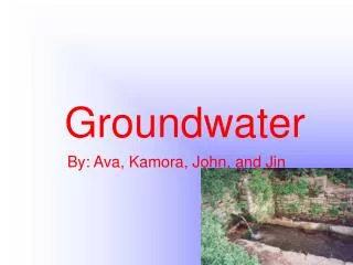
GROUNDWATER
Uncover the mysteries of groundwater and its crucial role in the hydrosphere. Learn about the zones of groundwater, rock properties affecting storage, topography's influence on water tables, and erosion and deposition processes shaping landscapes. Discover the wonders of caves, sinkholes, and karst topography, as well as challenges posed by hard water. Dive into the fascinating world of speleothems and the intricate formations they create underground.

GROUNDWATER
E N D
Presentation Transcript
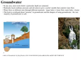
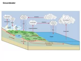
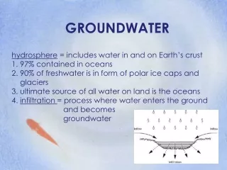
GROUNDWATER hydrosphere = includes water in and on Earth’s crust 1. 97% contained in oceans 2. 90% of freshwater is in form of polar ice caps and glaciers 3. ultimate source of all water on land is the oceans 4. infiltration = process where water enters the ground and becomes groundwater
groundwater = underground water that fill almost all pores in rock and sediment 1. pores = spaces between fragments of weathered rock and sediments 2. supplies about 1/5 of freshwater needs 3. groundwater system = area that has connecting pores
ZONES OF 1. zone of saturation = layer of ground where all the pores are filled with water a. gravitational water = water that trickles down due to gravity b. capillary water = water drawn upward from water table 2. water table = upper surface of zone of saturation a. depth varies depending on local conditions b. topography will follow topography of land above it c. dependent on precipi- tation so will vary with seasonal and other weather conditions d. rise during wet season, drops during dry seasons
3. zone of aeration = lies between water table and earth’s surface a. uppermost region = holds soil water - forms film around grains of topsoil b. middle region = normally remains dry except during rainfall, mostly air c. capillary fringe = bottom region 1) water drawn up from zone of saturation 2) capillary action = attraction of water molecules to other materials
ROCK PROPERTIES THAT AFFECT MOVEMENT & STORAGE 1. flows downhill in direction of slope of water table due to gravity a. rate depends on: permeability of materials and gradient of water table b. flow velocities through permeable materials is always higher than those through impermeable materials
2. porosity = percentage of open spaces in a given volume of rock or sediment a. determines the amount of water a rock can hold b. can be fractures, cavities, or pores c. influenced by: 1) sorting = amount of uniformity in size of particles in sediment or rock a) well sorted has particles all about same size b) poorly sorted has particles of many sizes mixed together 2) way particles are packed together a) packed loosely then has many open spaces → high porosity b) tightly packed → few open spaces → low porosity
3. permeability = how freely water passes through open spaces in rock or sediment a. affected by size and sorting of particles that make up a rock or sediment b. most permeable rocks are those made up of coarse particles Ex: sandstone c. impermeable = rock or sediment through which water cannot move Ex: clay
4. aquifer = layer of permeable rock that has connecting pores and transmits water freely a. large amounts of water can flow through b. contains porous layers of sediments such as sand and gravel, sandstone, and limestone c. aquicludes = impermeable layer that provides a barrier to groundwater flow
TOPOGRAPHY AND WATER TABLE 1. water table is found at different depths below ground surface 2. depth depends on a. topography of land b. permeability of rock c. amount of rainfall 3. prolonged rainfall → water table rises 4. drought periods → water table drops and flattens
5. perched water table = secondary water table formed by a layer of impermeable rock above the main water table a. rock layer prevents water from seeping down into the zone of saturation b. water collects on top creating a second water table 6. most areas only have one water table
EROSION & DEPOSITION 1. usually slightly acidic and will attack and dissolve carbonate rocks such as limestone 2. cave = natural underground opening with connection to Earth’s surface 3. caverns = large cave often containing many smaller, connecting chambers a. chemical weathering enlarges a number of connected cracks and cavities b. common in areas with extensive limestone deposits c. water is slightly acidic [carbonic acid]
4. sinkholes = circular depression caused when roof of cavern collapses a. can extend below water table b. usually occurs during dry periods 5 karst topography = region where the effects of chemical weathering due to groundwater are clearly visible a. may include closely spaced sinkholes, caverns, and streams that disappear b. can appear in arid regions c. sinking stream = surface streams that drains into a cave system
6. hard water = contains relatively large amounts of dissolved minerals a. usually ions of calcium, magnesium, and iron b. common in limestone areas c. unacceptable for many common uses 1) soap will not produce suds 2) has metallic taste 3) household appliances or fixtures may have build up of minerals d. soft water = contains few dissolved minerals
7. speleotherms = all mineral deposits formed in caves by the action of water a. stalactites = cone shaped calcite deposit suspended from the ceiling of a cavern b. stalagmites = cone shaped calcite deposit built up from the cavern floor c. column = formed when a stalactite and stalagmite grow together d. referred to as dripstone formations because these are formed from dripping water e. composed of travertine
8. veins = areas of igneous rock where hot groundwater collects metallic ions in solution and then deposits them in metallic ores 9. natural bridge = arch of rock a. uncollapsed rock between pairs of sinkholes b. can form when surface river enters a crack in rock formation, runs underground, then re-emerges
GROUNDWATER SYSTEMS: SPRINGS 1. ordinary springs = natural flow of groundwater to the earth’s surface a. commonly found in rugged terrain and hillsides b. ground surface drops below water table, usually do not flow continuously c. emerge on sides of valleys, edges of perched water tables, along faults d. those that form where there is a perched water table may flow continuously e. in areas where an aquifer and an aquiclude come in contact f. karst spring = area where an entire river emerges from the ground
2. artesian spring = natural flow of water to earth’s surface from an artesian formation a. form when cracks naturally occur in cap rock b. water under pressure flows to surface c. also called fissure springs
3. hot springs = hot groundwater that rises to surface before cooling a. water heated when comes into contact with magma or passes through areas where there has been recent volcanic activity b. temperature must be at least 37oC c. contains large concentrations of minerals
4. geysers = hot springs that erupt periodically a. shoots up water and steam b. narrow vent leads to surface and connects with one or more underground chambers c. eruptions: 1) from surface pools shooting sheets of water and steam 2) from small surface vents sending narrow columns of water and steam high into air d. geyserite = deposit of silicate mineral that forms
5. travertine = form of calcite that is deposited in terraces around the mouth of hot springs a. usually white but turns gray as it weathers b. can also be red, brown, or yellow
6. mud pots = weathered rock around hot spring that mixes with hot water to form liquid clay that bubbles at surface a. rock surrounding hot spring is chemically weathered by volcanic gases b. also called paint pots = clay can be colored by minerals and organic materials
WELLS: 1. ordinary well = hole dug below water table a. must go down into zone of saturation below water table b. if not deep enough it will dry up when water drops below water table c. pump brings water to surface 1) cone of depression = lowered area of water table produced by pumping water from well 2) can drop to bottom of well causing it to dry 3) could also cause surrounding well in area to go dry d. drawdown = difference between original water-table level and water level in pumped well e. recharge = water from precipitation and runoff is added back to zone of saturation
2. artesian well = hole dug through cap rock of artesian formation through which water flows freely a. no pumping is necessary b. artesian formation = sloping layer of permeable rock sandwiched between two aquicludes and exposed at surface c. cap rock = top layer of impermeable rock d. aquifer → permeable rock layer e. water in lower part is under pressure from weight of water above
THREATS TO WATER SUPPLY 1. overuse = supplies can be depleted is water is pumped out at a rate greater than recharge rate a. supply will decrease b. water table will drop 2. subsidence = sinking of land due to excessive withdrawal of water
3. pollution a. most easily polluted are water-table unconfined aquifers b. if recharge area of confined aquifer becomes polluted these aquifers will also be polluted c. most common sources are sewage, industrial waste, landfills, and agricultural chemicals d. chemicals are dissolved and transported as ions so they cannot be filtered out in sediments e. at coastal areas contamination of water by salt water; if water table drops below sea level this allows salt water to enter f. natural pollution source is radioactive radon gas
PROTECTING 1. all major pollution sources need to be identified and eliminated 2. pollution plumes already in ground can be monitored; move slowly a. time to find alternate water supply b. stop by building impermeable underground barriers 3. polluted groundwater can be pumped to surface for chemical treatment 4. conserve by: a. regulating use b. monitoring level of local water table c. discourage excessive pumping when water table is low