Download
1 / 32
320 likes | 632 Vues
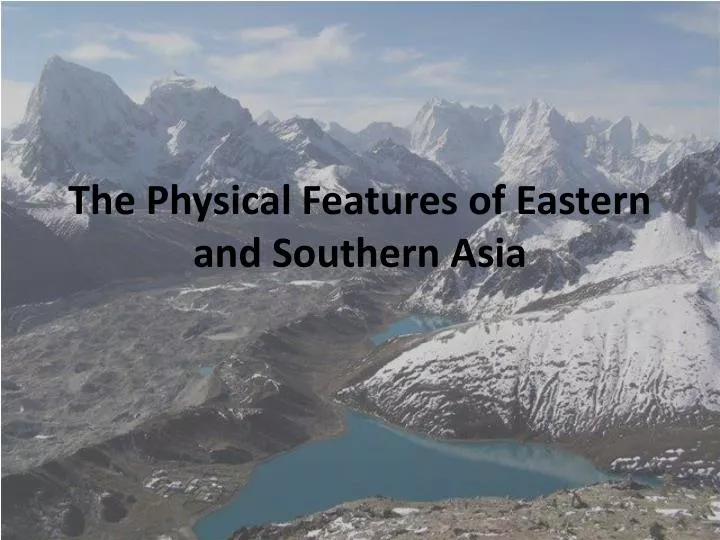
The Physical Features of Eastern and Southern Asia. The Ganges River. Ganges River. Starts at the base of the Himalayas in northeastern India Flows southeast through eastern India and into Bangladesh before emptying into the Bay of Bengal.

E N D
Ganges River Starts at the base of the Himalayas in northeastern India Flows southeast through eastern India and into Bangladesh before emptying into the Bay of Bengal. Major water source for the people of India and Bangladesh. Flooding of the river provides fertile soil for millions of farms along its banks. Millions of people live along the Ganges River Delta in Bangladesh. Sacred river to Hindus living in India.
Ganges River Sacred River of Hinduism Millions of Indians bathe in the Ganges every day.
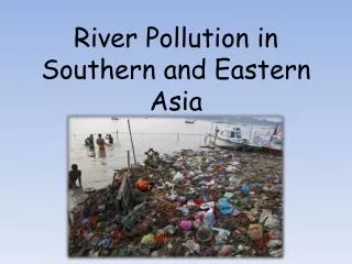
Ganges River Pollution The Ganges River is heavily polluted. The water in the river contains large amounts of industrial and human waste.
Indus River Begins in the Himalayas in the nation of Tibet and flows southwest into Pakistan. The river empties into the Arabian Sea. 21st longest river in the world. Numerous tributaries, or smaller rivers, flow into the Indus River. Provides water for millions of people living in Pakistan.
Indus River The Indus begins in the foothills of the Himalayas. The Indus River forms a large delta before emptying into the Arabian Sea.
Mekong River The Mekong River begins in the mountains of southern China and flows south through Tibet, Myanmar, Laos, Thailand, Cambodia, and Vietnam. The Mekong empties into the South China Sea. Longest river in Southeast Asia. 12th longest river in the world. Millions of Southeast Asians rely on the Mekong River for freshwater, fertile soil, and transportation.
Mekong River Fish from the Mekong provide food for millions of people living along the Mekong River. There are many small towns and markets that are located on the Mekong River.
Huang He River The Huang He begins in central China and flows generally east. The Huang He empties into the Yellow Sea. The Huang He is China’s second longest river. Hundreds of millions of people live along its banks and depend on it daily for food, water, and transportation. Also called the Yellow River because of the yellow tinted soil found on the river’s bottom.
Huang He River Also called China’s Sorrow because its floods have killed millions of people Numerous hydroelectric dams are located on the river which provide power to cities within China.
Chang Jiang River The Chang Jiang begins in central China and flows 3,915 miles before emptying into the East China Sea. The Chang Jiang, also called the Yangtze River, is the 3rd longest river in the world and the longest river in Asia. Nearly 2/3 of China’s people live along the Chang Jiang’s banks and depend on it for water, food, and transportation. The Three Gorges Dam, one of the world’s largest, is located on the Chang Jiang and provides power for millions of Chinese.
Pollution of Chang Jiang and Huang He The Chang Jiang and Huang He are both heavily polluted by the hundreds of millions of people who live along its banks. China’s growing industries have also heavily polluted the rivers by dumping their waste directly into the rivers.
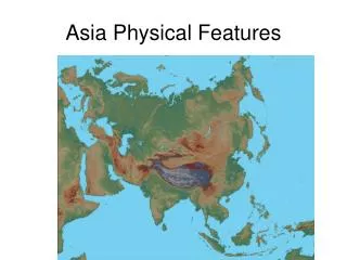
Gobi Desert The Gobi Desert is located in southern Mongolia and northern China. One of the largest deserts in the world and the largest desert in Asia. Majority of the desert is bare rock and not sand. The desert is named for the Mongolian word gobi which means “waterless place”.
Himalayas The Himalayas are a mountain system that is located in China, India, Nepal, Tibet, and Bhutan. The majority of the world’s tallest mountains, including Mt. Everest, are a part of the Himalayan range. Over 100 peaks with elevations over 24,000 feet are a part of the Himalayas. Melting snow from the range’s mountains is the source for numerous Asian rivers including the Ganges, Indus, and Brahmaputra.
Mt. Everest Mt. Everest is a part of the Himalayas. The mountain is located on the border of Nepal and Tibet (China). At 29,035 feet, it is the world’s tallest mountain. Due to plate tectonics, Mt. Everest grows a few millimeters every year. Thousands of people have attempted to climb Mt. Everest. The first to successful ascent was made in 1953. Hundreds of people have died attempting to climb Mt. Everest.
Mt. Everest Climbing route up Mt. Everest.
Bay of Bengal The Bay of Bengal is part of the Indian Ocean and is bordered by Sri Lanka, India, Bangladesh, Myanmar, and Malaysia. Numerous long rivers including the Ganges and Brahmaputra empty into the Bay of Bengal. The Bay of Bengal is major transportation route for shipping and many major cities are located along its shores.
Sea of Japan The Sea of Japan is a body of water located between the Asian mainlandand Japan. It is also bordered by Russia, North Korea, and South Korea. The Sea of Japan is also called the East Sea or the East China Sea. The sea is used as a major shipping route from Japan to the Asian mainland.
South China Sea The South China Sea is a part of the Pacific Ocean. Numerous large Chinese cities are located along the shores of the South China Sea. The South China Sea is a major shipping route from the Asian mainland to nations south of China.
Yellow Sea The Yellow Sea is part of the Pacific Ocean. The majority of the sea is located between China and the Korean peninsula. The sea is a major shipping route for ships carrying cargo from Chinese and South Korean businesses.