Download
1 / 6
80 likes | 194 Vues
Workshop on the Strategy and Action Plan of the WMO Flood Forecasting Initiative Geneva, 8 – 10 December 2009. Flood Forecasting Issues in Ghana by J. Wellens-Mensah hsd@ghana.com. FFI Workshop, Geneva, 8 – 10 December 2009.

E N D
Workshop on the Strategy and Action Plan of the WMO Flood Forecasting InitiativeGeneva, 8 – 10 December 2009 Flood Forecasting Issues in Ghana by J. Wellens-Mensah hsd@ghana.com
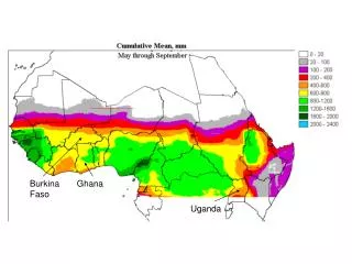
FFI Workshop, Geneva, 8 – 10 December 2009 • Summary of Main Regional Conclusions for WMO Region I (Africa) contained in Doc.3 are mostly relevant to the Ghanaian Situation • Additional Issues specific to Ghana include: • Ghana experiences both urban and rural/widespread flooding • inadequate infrastructure, instruments and equipment to collect and transmit hydro-met data in real time mode; • need for a network of calibrated radars for rainfall prediction and estimation;
FFI Workshop, Geneva, 8 – 10 December 2009 • Ghana also experiences flooding from dam spills in upstream country; • These spills are beneficial for filling up reservoirs for hydropower generation, but causes severe flooding on way to the reservoirs • need to synchronise spilling with conditions in downstream channels • need for timely communication of scheduled, controlled and phased spilling from upstream country
FFI Workshop, Geneva, 8 – 10 December 2009 • Flood Forecasts must save lives and limit flood damages; therefore forecasts should provide adequate warning and response measures • This, among others, requires delineation of flood plains in relation to flood magnitudes; • need to combine GIS with DEMs • in turn, requires digitised topographic maps at appropriate scale (currently exist in 1:2,500) • Need to control development in delineated natural flood plains eg. siting settlements and villages (keeping people and properties away from flood waters)
FFI Workshop, Geneva, 8 – 10 December 2009 • Ghana has streamflow forecasting models for inflows for management of hydropower, potable water supply and irrigation reservoirs; • There is no comprehensive Flood Forecasting System, except for ad hoc warnings based on levels in rivers; • Need to develop end-to-end flood forecasting systems taking advantage of state-of-the art observing systems, data transmission, modelling (eg. using NWP inputs), transmission of flood warnings, scenarios generation and response measures.
FFI Workshop, Geneva, 8 – 10 December 2009 Thank you !