Download

1 / 18
180 likes | 269 Vues
Explore the evolution of Warn-On-Forecast technology, challenges, assumptions, and strategies for its implementation and utilization. Discover how collaboration is key to enhancing forecast accuracy and early warnings for severe weather events.

E N D
Collaborating on the Development of Warn-On-Forecast Mike Foster / David Andra WFO Norman OK Feb. 18, 2010
Norman Forecast Office Storm Prediction Center National Severe Storms Laboratory Collaboration Radar Operations Center OU ESRL/GSD Warning Decision Training Branch 1980 1985 1990 1995 2000 2005 | | | | | | 20xx > JDOP Science/Technology Operations Early algorithms JointHWT Pre-STORM WDSS OK Mesonet DOPLIGHT PAR CASA VFlo REFRACT VORTEX2 ProbWarn Warn-On- Forecast WDSS II JPOL IHOP VORTEX NEXRAD IOT&E II MAPS COPS QED Pre-AWIPS MARD Risk Reduction AWIPS MAR NSSL/SPC
2008 EWP Participants • Visiting Forecasters/Evaluators (26) • NWS Regions: Alaska, Central, Western, Southern, Western • Environment Canada • Hydrometeorological Service of Serbia • Cognizant Scientists (30) • NSSL, OU, CIMMS, WDTB, WFO-OUN, U. Mass, U. VA • WAS*IS: Dr. Eve Gruntfest • Weekly Coordinators • IT Coordinator • Plus other IT help from NWC • Operations Coordinator • EWP Team Leaders
OUN WRF • Convective initiation and mode • 4 km grid – ARW core • Initialize every hour – eight hour forecast • LAPS initialization – hot start radar • OUN WRF 20 km - boundary conditions
LOCAL WRF MODEL 18Z April 7 2008 Forecast for 23Z
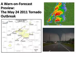
2 of 5 Warn on Forecast in 2020: What might it look like? Radar and Initial Forecast at 2100 CST Radar at 2130 CST: Accurate Forecast Forecast looks on track, storm circulation (hook echo) is tracking along centerline of highest tornadic probabilities An ensemble of storm-scale NWP models predict the path of a potentially tornadic supercell during the next 1 hour. The ensemble is used to create a probabilistic tornado hazard forecast grid. Most Likely Tornado Path Most Likely Tornado Path Developing thunderstorm 30% 30% 50% 50% 70% 70% T=2200 CST T=2200 CST T=2150 T=2150 T=2140 T=2140 T=2130 T=2130 T=2120 CST T=2120 CST Courtesy Lou Wicker, NSSL NSSL Warn on Forecast Briefing March 5, 2007
Alternative Warning and Forecast Formats • High temporal- and spatial-resolution probabilistic hazard grids
WoF Challenges • best approaches to radar data qc and assimilation into models • determining how WoFinformation will be used in NWS operations and communicatedto the public • storm-scale process understanding, predictability, and parameterization improvements • WoF project priorities, timing, evaluation and implementation strategies
Some assumptions… • WoF will evolve into operations • Not a turn key system • May be regional or local differences in implementation • There will remain a detection component • An alert notification will inform of high impact phenomena • Science and technology will continue to expand the number of observations, analyses and forecasts
…and some more… • Data volume and complexity will grow • Dual pol, Phased array , CASA • Ensemble regional, local andstorm scale models • New forecast and warning formats and dissemination • Hazard probability envelopes • Graphical • Text • More frequent updates possible • Techniques will require calibration • Techniques will require bias removal
…and more • Role of the human expert will change • Today’s warning forecaster processes inputs and makes warning decision • The same process tomorrow will mean many inputs not considered • Manage the process • Review • Assess • Correct • Many others…
Radar data quality control • Review and assess radar data in real time • Review and assess storm scale analysis in real time
Information use in operations and communication to users • A proving ground for operations • Dedicated WFO position(s) during event operations • Post-event reviews of information and actions • HWT
Information use in operations and communication to users • A proving ground for information • Graphicasts • Significant weather advisories • Warning decision updates • Interact with users groups; EMs, Schools, medical groups, local decision makers, SSWIM
Evaluation and implementation strategies • Evaluate suitability of storm scale forecasts • Risk reduction of phased implementation