Download
1 / 48
480 likes | 615 Vues
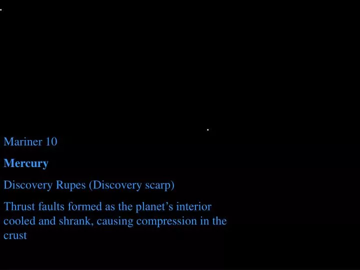
Mariner 10 Mercury Discovery Rupes (Discovery scarp) Thrust faults formed as the planet’s interior cooled and shrank, causing compression in the crust.

E N D
Mariner 10 Mercury Discovery Rupes (Discovery scarp) Thrust faults formed as the planet’s interior cooled and shrank, causing compression in the crust
Offset in a stream along the San Andreas Fault, CA. This photo is part of the classic collection of John Shelton’s book “Geology Illustrated”, considered to be one of the most influential popular scientific works of the 20th Century. • Tectonism When forces build up on rocks in the earth, the rocks eventually slip or break releasing the stored up energy in a sudden earthquake. Faults (planar offsets in rocks and landscape) are the features that form when the earth slips and moves.
Tectonism Graben are tectonic valleys (not erosional) formed in areas that are being pulled apart (extensional). A normal fault forms on each side of the valley and the middle drops down. These Graben valleys are in Canyonlands, Utah.
Tectonism Normal faulting on a grand scale: The Teton Mountains in Wyoming are on the up side of the fault, Jackson Hole and other areas east of the mountains are on the down side.
Tectonism A reverse fault forms under compressional forces. Notice the overlap in the layers indicating shortening that results from compression. (Montana)
Tectonism If rocks are very hot and under high pressure at the time of compression, they will fold (deform plastically) rather than break. These metamorphic rocks in Eastern Connecticut must have been deformed deep within the Earth and brought to the surface by erosion much later.
Tectonism • Syncline in a Washington County Maryland roadcut. • Notice that this picture also dispels any notion that a syncline must be in a valley!
Plunging syncline • Tectonism Plunging syncline just north of Half Moon Bay, CA. The word plunge indicates that the entire fold has been tilted, in this case downward in the direction away from the airplane.
Sequence of events: 1) deposition of sediments that become rocks, 2) rocks are buried, 3) rocks are folded deep in the roots of a mt range, 4) mts erode away and the folded rocks are exposed with a river flowing over them, 5) new tectonism begins to uplift new mountains and the river erodes across them. • Tectonism This Space Shuttle picture reveals not only 300mya folding in the Macdonnel mountain range in Australia (with compression in a north-south direction), but an amazing sequence of events: Because it’s not likely that the river ever flowed up over the mountains, the river must have been there before the mountains, and eroded through the mountains at the same rate the mountains were rising up.
Stone Mountain, GA above Weathering and Erosion. Mechanical Weathering results from unloading (causing exfoliation parallel to the surface), freezing and thawing of water (causing cracking in rocks and shattering along joints), heating and cooling (which causes rocks to expand and contract, breaking them apart), and other factors.
Weathering and Erosion. Oxidation of iron combined with leaching of soluble elements produces the red soils characteristic of humid, warm climates. Less-extensively weathered bedrock is seen in the lower part of the image.
Weathering and Erosion. Gravity is one of the primary erosional forces. Mass Wasting occurs when rocks move downward under the force of gravity. Despite the warning sign and flag, not all tourists in Kefalonia Greece understand the risk!
Weathering and Erosion. Soil moves downward under the force of gravity in a process called creep. The trees on the Wasatch Plateau in Utah chart the movement of the soil by always turning to grow upward as the rotation of the soil tries to tilt them over.
Weathering and Erosion. Gravity and rain conspire to create many unusual features. Here resistant boulders provide a protective cap for cone-shaped Hoodoos.
Weathering and Erosion. Spectacular arches in Arches NP, Utah are produced by a combination of mechanical weathering by wind blown sand, chemical and mechanical weathering by water, presence of a resistant cap rock, vertical fractures in the original rock layer (now long gone), and gravity.
Weathering and Erosion. Rainwater runoff has carved the castles and spires of Bryce Canyon NP, Utah. Exposed roots of the small pine tree reveal the rate at which sediment is eroding from the upper rim of the erosional amphitheater.
Weathering and Erosion. Dendritic (tree-like) drainage patterns form from surface rivers flowing over areas of high rainfall and uniform underlying rock. Eastern flank of Andes in Argentina. Space Shuttle image.
Weathering and Erosion. Classic work of river erosion, Grand Canyon as seen from the south rim. More resistant layers form cliffs, less resistant layers form slopes.
Weathering and Erosion. Sometimes after a river has reached its base level and a meandering channel is established, tectonic events cause the region to be uplifted, and downward erosion is renewed. The result is entrenched meanders, such as these along the San Juan River in Utah.
Weathering and Erosion. As a region erodes down to base level, a broad plain develops, often containing a few remnant buttes or hills. Imagine the now-eroded layer of sandstone that must have once stretched between the buttes. Mitten Buttes, Arizona, Cutler Formation.
Weathering and Erosion. Energy from wind-driven waves (not just tides) can cause significant coastal erosion. Clockwise from Upper left: Ocean Beach San Francisco, Great lakes, Oregon Coast.
Weathering and Erosion. One of the clues that convinced early geologists in the 1800s that the Earth had to be “very old” was the presence of erosion surfaces underneath other rock. The feature shown here (from Portugal), tells the story first of sediments that were deposited and turned to rock (the lower in-place rocks). Then, these rocks were folded deep in the Earth’s crust by powerful compressional forces that must have built mountains. Then the overlying rocks and mountains were eroded away (producing the erosional surface). New sediments were deposited on top of the erosional surface and turned to rock, and finally, erosion exposed the whole sequence. This feature is called an Angular Unconformity.
Deposition and Stratigraphy. Animation of angular unconformity generation.
Deposition and Stratigraphy. Alternating episodes of deposition and erosion are necessary to explain the presence of unconformities such as this angular unconformity at Shepherd Point, Utah. In general, erosion occurs where rock is uplifted and gravity, wind, water, or ice carries weathered sediment away. Deposition occurs either where water/air movement slows, allowing particulate matter to settle out, or where conditions are right for sediments to crystallize from solution.
Deposition and Stratigraphy. The “V” shaped canyon in Death Valley CA reveals erosion in the upland. The alluvial fan forms where sediment is deposited in the lower-energy environment that occurs where slope decreases. Classic John Shelton photo
Deposition and Stratigraphy. The currently-active part of the Mississippi Delta as seen with the ASTER imager of the Terra Satellite. Sediment is deposited by branching distributary channels where the river water stops flowing upon encountering the sea. With less water movement, the sediment settles out. Sufficient sediment is carried by the river to extend the delta by about 300 feet each year.
Former Location of Harbor Deposition and Stratigraphy. In the days when Paul the Apostle spent two years preaching in Ephesus on the western coast of Asia Minor, the region of the Great Theater looked out on a beautiful bay much like that at modern Izmir. The walkway led from the theater to the harbor. Years later, sediment carried by the river silted up the bay and the site is now landlocked. Agricultural practices in the region probably speeded up the erosion and deposition process.
Deposition and Stratigraphy. A high energy environment, such as a beach subject to severe storms, will wash away small particles and deposit larger particles. At left is a modern high energy beach on the North Shore of Lake Superior. Above is a conglomerate (Schunemuck Mountain Conglomerate) deposited on an ancient Devonian high energy beach (much later exposed and polished by glacial erosion).
Deposition and Stratigraphy. Low-energy environments of deposition include a swamp (left) and a lagoon (below on left, protected from open ocean waves by a barrier island). Sediments in the swamp and lagoon will be muddy and organic-rich. Sediments along the higher-energy foreshore and dunes will be sandy. Above: Cypress swamp near Albany Georgia. Right: Barrier island and marsh lagoon, Plum Island Massachusetts.
Deposition and Stratigraphy. MISR image of the Great Barrier Reef, Australia. Deposition of CaCO3 sediment from solution in sea water to make limestone usually occurs where the supply of particulate sediment is low. Deposition of chemical sediments doesn’t depend on the energy in the environment of deposition, since there are no particles to “settle out”.
Deposition and Stratigraphy. Coral reefs often form in warm climates where water temperatures and salinities are very stable. The stability results in great diversity of life. Great Barrier Reef, Australia
Deposition and Stratigraphy. Coral reefs often form in areas with lots of sunlight and food, resulting in a great abundance of lifeGBR
Deposition and Stratigraphy. A common, if somewhat simplified, sequence of sediments on a continental shelf (going from the beach out to sea) is sandstone (where moderate energy waves wash finer sediment away), mud (both silt and clay deposited in deeper water where there is less water movement), and carbonate sediments (CaCO3-based sediments deposited where little particulate sediment reaches). These sediments become the rock types sandstone, shale, and limestone. A concept called Walther’s Law suggests that sediments that occur adjacent to each other in modern environments may have become stacked on top of each other in the past due to migration of environments through time.
Deposition and Stratigraphy. Many layers are stacked on each other in the Grand Canyon AZ. Notice three layers in the lower right: TS = Tapeats sandstone, BAS = Bright Angel Shale, and ML = Mauve Limestone. Notice that they are in the same sequence typical of shorelines, but stacked on top of each other instead of side by side.
Deposition and Stratigraphy. The sequence (upward) of sandstone, shale, limestone can occur in a stacked sequence if an ocean advances over an area slowly, depositing sandstone first, then as the water deepens, shale and limestone later (and thus on top of the sandstone). Therefore, this sequence at the Grand Canyon is the record of an ocean advancing over this area during the Cambrian time period.
Deposition and Stratigraphy. When the sea transgressed over the region of the Grand Canyon, it advanced over a pre-existing erosional surface. Rocks exposed at that ancient surface included metamorphic Schist, Igneous Granite, and tilted PreCambrian sedimentary layers. The surface beneath the Tapeats Sandstone (labeled with a “2”) is called the Great Unconformity. The surface labeled “1” is an even more ancient unconformity.
Deposition and Stratigraphy. Tilted Precambrian rocks lie below the Great Unconformity in the lower half of the image. Above the unconformity is, in sequence, the Tapeats Sandstone (making a cliff), Bright Angel Shale (making a slope), and the Mauve Limestone (making a short cliff below the more prominent cliff-former at the top of the butte). This tells the following story: 1) ancient deposition, 2) tilting of rocks, 3) erosion of rocks, 4) advance of an ocean that deposited new rocks, and finally 5) recent erosion of the canyon that has exposed it all.
Life Processes • Tree roots cause both physical and chemical weathering. Physical weathering is due to the outward pressure provided by turgor pressure in the cells that can force cracks wider. Chemical weathering is due to acids produced by the tree and ion exchanges of the rootlets.
Life Processes Humans are one of the most significant erosional forces on Earth, moving more rock and sediment per year than almost any other single process. This is the Kennecoff Mine in Utah, an open pit mine producing copper, molybdenum, gold and silver.
Life Processes Almost all species that have ever lived are now extinct, and the creatures alive today did not exist just a geological moment ago (that is, we do not find fossils of those creatures in rocks from the geological past). Therefore, we reasonably conclude that life is a dynamic and changing part of Earth. Ice Ages, modern human Hominids, whales, Mammals Dinosaurs, flowering plants Dinosaurs, conifers Dinosaurs, mammals Reptiles, mammal-like reptiles Reptiles, giant insects, coal swamps Amphibians and crinoids Sharks and armored fish Land Plants and Eurypterids Fish and Coral Trilobites Eukaroytic life, single celled and simple organisms Prokaryotes, blue green algae and cyanobacteria
Life Processes Example life from the Mesozoic, the Age of Reptiles. Percent of Mesozoic species extinct > 99%. Clockwise from u-left, Tricerotops (a ceratopsian), Chasmosaur Belli (a ceratopsian), Tyrannosaurus (a therapod), and Lambeosaurus (an ornithopod), all dinosaurs.
The following slides are a preview of plate tectonics for our next section
Tectonism • Illustration of the main types of Tectonic Plate boundaries and their features (including mountain belts, volcanic chains, isolated volcanoes, trenches, and high plateaus. Earth is the only planet known with this style of Plate Tectonics.
Space Station EarthVolcanoes in Mexico form chains running parallel to the plate tectonic convergent boundary.
Tectonism Compressional forces at convergent plate boundaries can thicken the crust in those areas, producing mountains. French Alps.
Lakes and volcanoes in the rift valley. Space Shuttle Topographic Map of East Africa Rift.
Gemini 11 (right), Apollo 17 (above) Plate tectonic rift, opening of the Red Sea and Gulf of Aden between Arabian Peninsula and Horn of Africa
Tectonism Illustration of plate motions, plate boundaries, and changes in continents from the end of the Precambrian until today; NAM = North America, BAL=Baltic1 sec = 10 million years. after PGISMac by Malcolm Ross and Christ Scotese and Paleomap Project by Chris Scotese.