Download
1 / 1
10 likes | 134 Vues
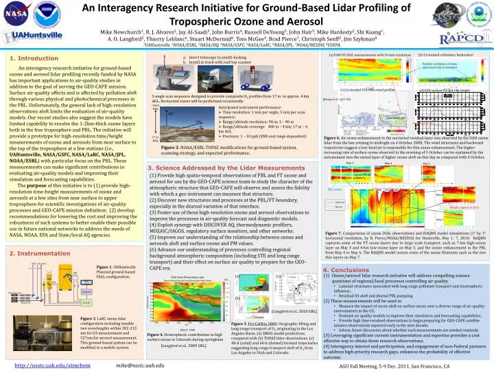
An Interagency Research Initiative for Ground-Based Lidar Profiling of Tropospheric Ozone and Aerosol . ~4 km AGL. 90º. Mike Newchurch 1 , R . J. Alvarez 2 , Jay Al-Saadi 3 , John Burris 4 , Russell DeYoung 5 , John Hair 5 , Mike Hardesty 2 , Shi Kuang 1 ,

E N D
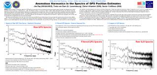
An Interagency Research Initiative for Ground-Based Lidar Profiling of Tropospheric Ozone and Aerosol ~4 km AGL 90º Mike Newchurch1, R. J. Alvarez2, Jay Al-Saadi3, John Burris4, Russell DeYoung5, John Hair5, Mike Hardesty2, Shi Kuang1, A. O. Langford2, Thierry Leblanc6, Stuart McDermid6, Tom McGee4, Brad Pierce7, ChristophSenff2, Jim Szykman8 1UAHuntsville, 2NOAA/ESRL, 3NASA/HQ, 4NASA/GSFC, 5NASA/LaRC, 6NASA/JPL, 7NOAA/NESDIS, 8USEPA, 10º 2º 17 m AGL Introduction An interagency research initiative for ground-based ozone and aerosol lidar profiling recently funded by NASA has important applications to air-quality studies in addition to the goal of serving the GEO-CAPE mission. Surface air-quality affects and is affected by pollution aloft through various physical and photochemical processes in the PBL. Unfortunately, the general lack of high-resolution observations aloft limits the evaluation of air-quality models. Our recent studies also suggest the models have limited capability to resolve the 1-2km-thick ozone layers both in the free troposphere and PBL. The initiative will provide a prototype for high-resolution time/height measurements of ozone and aerosols from near surface to the top of the troposphere at a few stations (i.e., UAHuntsville, NASA/GSFC, NASA/LaRC, NASA/JPL, NOAA/ESRL) with particular focus on the PBL. These measurements can make significant contributions in evaluating air-quality models and improving their simulation and forecasting capabilities. The purpose of this initiative is to (1) provide high-resolution time-height measurements of ozone and aerosols at a few sites from near surface to upper troposphere for scientific investigations of air-quality processes and GEO-CAPE mission definition; (2) develop recommendations for lowering the cost and improving the robustness of such systems to better enable their possible use in future national networks to address the needs of NASA, NOAA, EPA and State/local AQ agencies. (b) Co-located ceilometer backscatter (a) UAH O3 DIAL measurements with 10-min resolution Invert telescope to zenith-looking Install in truck with roof top scanner Positive correlation of ozone and aerosol due to transport (c) Co-located 915-MHz wind profiler (d) EPA surface O3 and CBL height 3-angle scan sequence designed to provide composite O3 profiles from 17 m to approx. 4 km AGL. Horizontal stares will be performed occasionally. [Kuang et al., 2011 AE]. Oct. 1 Oct. 2 • Anticipated instrument performance • Time resolution: 1 min per angle; 5 min per scan sequence; • Range/altitude resolution: 90 m; 3 – 90 m • Range/altitude coverage: 400 m – 4 km; 17 m – 4 km AGL • Precision: 1 – 10 ppb (SNR and range dependent) Low-level jet Oct. 4 Oct. 3 Higher increasing rate Telescope Lidar Control DAQ System Receiver Box Oct. 5 Oct. 6 Figure 6. An ozone enhancement in the nocturnal residual layer was observed by the UAH ozone lidar from the late evening to midnight on 4 October 2008. The wind structures and backward trajectories suggest a low-level jet is responsible for this ozone enhancement. The higher increasing rate of surface ozone observed in the morning of 5 October can be explained by the entrainment into the mixed layer of higher ozone aloft on this day as compared with 4 October. Laser Transmitter Figure 3. NOAA/ESRL TOPAZ modifications for ground-based system, scanning strategy, and expected performance. May 3 May 4 May 5 3. Science Addressed by the LidarMeasurements • (1) Provide high spatio-temporal observations of PBL and FT ozone and aerosol for use by the GEO-CAPE science team to study the character of the atmospheric structure that GEO-CAPE will observe and assess the fidelity with which a geo instrument can measure that structure. • (2) Discover new structures and processes at the PBL/FT boundary, especially in the diurnal variation of that interface. • (3) Foster use of these high-resolution ozone and aerosol observations to improve the processes in air-quality forecast and diagnostic models. • (4) Exploit synergy with DISCOVER AQ, thermodynamic profilers, MOZAIC/IAGOS, regulatory surface monitors, and other networks. • (5) Improve our understanding of the relationship between ozone and aerosols aloft and surface ozone and PM values. • (6) Advance our understanding of processes controlling regional background atmospheric composition (including STE and long range transport) and their effect on surface air quality to prepare for the GEO-CAPE era. Daytime PBL top collapsed EPA surface May 1 May 2 May 3 May 4 May 5 May 6 May 7 May 8 May 6 Captured Missed 89ppbv, highest in 2010 May 7 Figure 7. Comparisons of ozone DIAL observations and RAQMS model simulations (1° by 1° horizontal resolution, by B. Pierce/NOAA/NESDIS) for Huntsville, May 1- 7, 2010. RAQMS captures some of the FT ozone layers due to large scale transport, such as 7-km high-ozone layer on May 3 and 4-km low-ozone layer on May 5, and the ozone enhancement in the PBL from May 4 to May 6. The RAQMS model misses some of the ozone filaments such as the two thin layers on May 7. 2. Instrumentation Figure 1. UAHuntsville Planned ground-based DIAL configuration. 30Hz, 6 mJ/pulse 4. Conclusions • Ozone/aerosol lidar research initiative will address compelling science questions of regional/local processes controlling air quality. • Laminar structures associated with long range pollutant transport and stratospheric influence; • Residual O3 aloft and diurnal PBL pumping. • (2) These measurements will be used to • Measure the impact of ozone aloft on surface ozone over a diverse range of air-quality environments in the US; • Evaluate air quality models to improve their simulation and forecasting capabilities; • Provide high time-resolved observations to begin preparing for GEO-CAPE satellite mission observations expected early in the next decade; • Inform future discussion about whether such measurements are needed routinely. • (3) Leveraging significant current instrumentation and expertise provides a cost effective way to obtain these research observations. • (4) Interagency interest and participation, and engagement of non-Federal partners to address high-priority research gaps, enhances the probability of effective outcome. (c) (a) 289 299 283 16” Telescope 4” PMT 4 1” (b) 5 10% Web server 2 299 289 [Langford et al., 2010GRL] 90% 1 3 Computer Figure 2. LaRC ozone lidar configuration including tunable two wavelengths within 282-313 nm for O3 measurement and 527nm for aerosol measurement. This ground-based system can be modified to a mobile system. 266 pump laser 283/289/299 Figure 5. Pre-CalNex 2009: Orographic lifting and long-range transport of O3 originating in the Los Angeles Basin. (a) SMOG model predictions compared with (b) TOPAZ lidarobservations. (c) 48-h (solid) and 60-h (dotted) forward trajectories suggesting long-range transport aloft of O3 from Los Angeles to Utah and Colorado. 283/289/299 283/289/299 YAG N2 YAG D2 Figure 4. Stratospheric contribution to high surface ozone in Colorado during springtime Licel TR YAG H2 Raman cell [Langford et al., 2009 GRL] AGU Fall Meeting, 5-9 Dec. 2011, San Francisco, CA http://nsstc.uah.edu/atmchemmike@nsstc.uah.edu