Using CORS and OPUS for Positioning
Using CORS and OPUS for Positioning . Richard Snay NOAA’s National Geodetic Survey GIS-T Charleston, West Virginia April 14, 2010. NOAA’s National Geodetic Survey. Everyone is able to know where they are and. where other things are anytime, anyplace!.

Using CORS and OPUS for Positioning
E N D
Presentation Transcript
Using CORS and OPUS for Positioning Richard Snay NOAA’s National Geodetic Survey GIS-T Charleston, West Virginia April 14, 2010
NOAA’s National Geodetic Survey Everyone is able to know where they are and where other things are anytime, anyplace!
The Global Positioning System (GPS) Unaugmented GPS enables positioning with accuracies ranging from 1 to 10 meters.
The CORS network enables differential GPS positioning with accuracies from 1 to 10 centimeters, or better. Continuously Operating Reference Stations (CORS)
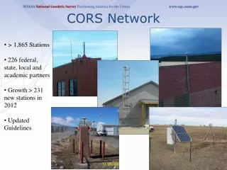
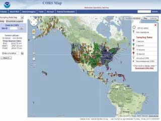
CORS Information • CORS network contains over 1,400 stations as of April 2010. • Growing at rate of about 200 stations per year. • Each station collects GPS signals, and NOAA makes these data freely available to the public via the Internet for post-processing applications. • Over 200 organizations participate in the CORS program by sponsoring and operating one or more stations.
Access to CORS Data In Silver Spring, Maryland (CORS-East) • Anonymous File Transfer Protocol (FTP) ftp://cors.ngs.noaa.gov • UFCORS - User Friendly CORS http://www.ngs.noaa.gov/UFCORS In Boulder Colorado (CORS-West) • Parallel and independent data collection and on-line storage at NOAA’s National Geophysical Data Center Anonymous FTP ftp://wwwest.ngs.noaa.gov
CORS Supports Precise Positioning A A A A A Before CORS: Accurate differential GPS positioning with multi-person field crew. After CORS: Accurate differential GPS positioning with one-person field crew.
Vertical standard error achievable when a user submits 15 minutes of GPS data to OPUS-RS
Vertical Standard error achievable when a user submits 1 hour of GPS data to OPUS-RS
Horizontal standard error achievable when a user submits 15 minutes of GPS data to OPUS-RS
Horizontal standard error achievable when a user submits 1 hour of GPS data to OPUS-RS
Positioning Accuracy with Code Data Observation Time = 1 minute red = east-west blue = north-south RMS error = 25 cm + 2 ppm
Aircraft Positioning with CORSResults using single CORS 3D RMS error = 15 cm + 0.6 ppm aaaaaaaaaaaaaaaaaaaaaaaaaaaaaaaaaaaaaaaaaaaaaaaaaaa aaaaaaaaaaaaaaaaaaaaaaaaaaaaaaaaaaaaaaaaaaaaaaaaaaaa
Online Positioning UserService (OPUS) ● Collect at least 15 minutes of dual-frequency GPS data • Submit data to www.ngs.noaa.gov/OPUS/ • Data are processed automatically using NOAA • computers & software • Corresponding positional coordinates computed • with respect to at least 3 suitable CORS or IGS sites • Computed coordinates returned via email • (usually in minutes)
OPUS Output FILE: corv0590.05o 000416827 1008 NOTE: Antenna offsets supplied by the user were zero. Coordinates 1008 returned will be for the antenna reference point (ARP). 1008 NGS OPUS SOLUTION REPORT ======================== USER: jeff.olsen@noaa.gov DATE: January 13, 2006 RINEX FILE: corv059f.05o TIME: 19:08:14 UTC SOFTWARE: page5 0601.10 master3.pl START: 2005/02/28 05:00:00 EPHEMERIS: igs13121.eph [precise] STOP: 2005/02/28 06:59:30 NAV FILE: brdc0590.05n OBS USED: 4228 / 4314 : 98% ANT NAME: ASH700936B_M NONE # FIXED AMB: 25 / 29 : 86% ARP HEIGHT: 0.0 OVERALL RMS: 0.013(m) REF FRAME: NAD_83(CORS96)(EPOCH:2002.0000) ITRF00 (EPOCH:2005.1596) X: -2498423.165(m) 0.018(m) -2498423.872(m) 0.018(m) Y: -3802822.048(m) 0.021(m) -3802820.836(m) 0.021(m) Z: 4454737.695(m) 0.024(m) 4454737.792(m) 0.024(m) LAT: 44 35 7.91054 0.002(m) 44 35 7.92698 0.002(m) E LON: 236 41 43.48129 0.014(m) 236 41 43.42434 0.014(m) W LON: 123 18 16.51871 0.014(m) 123 18 16.57566 0.014(m) EL HGT: 107.485(m) 0.034(m) 107.108(m) 0.034(m) ORTHO HGT: 130.010(m) 0.043(m) [Geoid03 NAVD88] UTM COORDINATES STATE PLANE COORDINATES UTM (Zone 10) SPC (3601 OR N) Northing (Y) [meters] 4936954.907 105971.557 Easting (X) [meters] 475821.322 2277335.385 Convergence [degrees] -0.21381402 -1.98897497 Point Scale 0.99960719 0.99994603 Combined Factor 0.99959034 0.99992918 US NATIONAL GRID DESIGNATOR: 10TDQ7582136955(NAD 83) BASE STATIONS USED PID DESIGNATION LATITUDE LONGITUDE DISTANCE(m) AH2489 NEWP NEWPORT CORS ARP N443506.072 W1240342.736 60138.7 AJ6959 CHZZ CAPE MEARS CORS ARP N452911.437 W1235841.187 113322.4 DH4503 P376 EOLARESVR_OR2004 CORS ARP N445628.313 W1230608.100 42648.2 NEAREST NGS PUBLISHED CONTROL POINT AH2486 CORVALLIS CORS ARP N443507.910 W1231816.519 0.0 NAD 83 coordinates (3D) ITRF coordinates (3D) NAVD 88 height State Plane coordinates UTM coordinates US National Grid A more comprehensive output is also available upon request.
OPUS add-ons DEFAULT OPTION OPUS FLAVOR US only global results OPUS-global hours of data minutes of data OPUS-RS no archive share results OPUS-DB one receiver multiple receivers OPUS-projects no delimiters delimited results OPUS-XML GPS only GNSS signals OPUS-GNSS
Just Around the Corner Within the next 12 months, the CORS system will: • Provide GPS L2C data • Provide GLONASS data • Broadcast GNSS data via the Internet in real-time (on an experimental basis). (For selected sites only.) Red dots identify locations of CORS sites that collect both GPS and GLONASS data.