Download
1 / 23
230 likes | 417 Vues
CORS and OPUS for GIS Applications. Richard Snay NOAA’s National Geodetic Survey ESRI International User Conference San Diego, California August 5, 2008. The Global Positioning System (GPS). Unaugmented GPS enables positioning with accuracies ranging from 1 to 10 meters.

E N D
CORS and OPUS for GIS Applications Richard Snay NOAA’s National Geodetic Survey ESRI International User Conference San Diego, California August 5, 2008
The Global Positioning System (GPS) Unaugmented GPS enables positioning with accuracies ranging from 1 to 10 meters.
The CORS network enables differential GPS positioning with accuracies from 1 to 10 centimeters, or better. Continuously Operating Reference Stations (CORS)
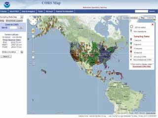
CORS Information • CORS network contains over 1,200 stations as of August 2008. • Growing at rate of about 200 stations per year. • Each station collects GPS signals, and NOAA makes these data freely available to the public via the Internet for post-processing applications. • Almost 200 organizations participate in the CORS program by sponsoring and operating one or more stations.
CORS Supports Precise Positioning A A A A A Before CORS: Accurate differential GPS positioning with multi-person field crew. After CORS: Accurate differential GPS positioning with one-person field crew.
Positioning Accuracy with Code Data Observation Time = 1 minute red = east-west blue = north-south RMS error = 25 cm + 2 ppm
Online Positioning UserService (OPUS) ● Collect at least 15 minutes of dual-frequency GPS data • Submit data to www.ngs.noaa.gov/OPUS/ • Data are processed automatically using NOAA • computers & software • Corresponding positional coordinates computed • with respect to at least 3 suitable CORS or IGS sites • Computed coordinates returned via email • (usually in minutes)
OPUS-S vs. OPUS-RS What are the fundamental differences between OPUS-Static (OPUS-S) and OPUS-Rapid Static (OPUS-RS)?
OPUS-S vs. OPUS-RS OPUS-S requires at least two hours of GPS data from the rover, together with the same amount of data from 3 CORS (preferably located within 1,000 km of the rover), to solve for * the rover’s coordinates, * atmospheric refraction parameters at both the rover and the 3 CORS, and * integer ambiguities (in the doubly differenced phase observations).
OPUS-S vs. OPUS-RS OPUS-RS involves a 3-step process: * Use at least one hour of GPS data from 3 to 9 CORS (located within 250 km of the rover) to solve for atmospheric refraction parameters at these CORS. * Interpolate (or extrapolate) these refraction parameters to predict corresponding refraction parameters at the rover. * Use at least 15 minutes of GPS data at the rover, together with the same amount of data at the nearby CORS to solve for: - the rover’s coordinates and - integer ambiguities.
What is IDOP? The interpolative dilution of precision (IDOP) is a unitless number that quantifies the local geometric strength of the CORS network relative to the rover’s location in terms of how well atmospheric conditions at nearby CORS can be interpolated (or extrapolated) to predict corresponding atmospheric conditions at the rover.
What is IDOP? If there are several (at least 3) CORS located within 250 km of the rover and we have estimated an atmospheric parameter for each of these CORS with a standard error of σ, then the corresponding atmospheric parameter at the rover can be predicted with a standard error of σR = (IDOP) • σ . Hence, the smaller the value of IDOP the better.
What is IDOP? Let (xi , yi) denote the location of the i-th CORS in the xy-plane for i = 1,2,3,…,n and let (x0 , y0) denote the location of the rover in the xy-plane, then IDOP = (R/Q)0.5 where R = (∑∆xi2)(∑∆yi2) – (∑∆xi∆yi)2 and Q = nR + 2(∑∆xi)(∑∆yi)(∑∆xi∆yi) – (∑∆xi)2(∑∆yi2) – (∑∆yi)2(∑∆xi2) Here ∆xi = xi – x0 and ∆yi = yi – y0 for i = 1,2, 3,…,n.
IDOP VALUES AS A FUNCTION OF LOCATION EXAMPLE FOR THE CASE OF 4 CORS LOCATED AT THE CORNERS OF A SQUARE Best IDOP = 1/√ N where N denotes the number of CORS. Best IDOP occurs at the centroid of the CORS. With these 4 CORS, the best IDOP = 0.5 and IDOP increases as the distance from the centroid increases. With 9 CORS, IDOP would equal 0.33 at the centroid of the CORS.
OPUS-RS Accuracy Depends on IDOP and RMSD RMSD = Root mean square distance = [ ( ∑ di2 ) / n ]0.5 where di is the distance between the rover and the i-th CORS, and n equals the number of CORS being used. • STDERR(north) ≈ [ (1.8cm•IDOP)2 + (0.05ppm•RMSD)2 ]0.5 • STDERR(east) ≈ [ (1.8cm•IDOP)2 + (0.05ppm•RMSD)2 ]0.5 • STDERR(up) ≈ [ (6.7cm•IDOP)2 + (0.15ppm•RMSD)2 ]0.5
Vertical standard error achievable when a user submits 15 minutes of GPS data to OPUS-RS
Summary • CORS enables submeter positioning with only 1 minute of single-frequency GPS (code) data throughout North America. • OPUS-S enables cm-level positioning with 2 hours of dual-frequency GPS (carrier phase) data throughout North America. • OPUS-RS enables cm-level positioning with only 15 minutes of dual-frequency GPS (carrier phase) data in most of CONUS.