Velocity
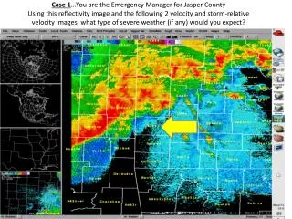
Case 1 …You are the Emergency Manager for Jasper County Using this reflectivity image and the following 2 velocity and storm-relative velocity images, what type of severe weather (if any) would you expect?. Velocity. Storm-Relative Velocity. STOP! DO NOT TURN PAGE.

Velocity
E N D
Presentation Transcript
Case 1…You are the Emergency Manager for Jasper CountyUsing this reflectivity image and the following 2 velocity and storm-relative velocity images, what type of severe weather (if any) would you expect?
STOP! DO NOT TURN PAGE
Case 2 (Part 1)…30 minutes later…You are the Emergency Manager for Dade County. Using reflectivity, velocity, and storm-relative velocity images, what kind of severe weather do you expect?
STOP! DO NOT TURN PAGE
Case 2 (Part 2)…A Severe Thunderstorm Warning has been issued for winds up to 100 mph for the boxed area, including your county…Dade (see next slide). What additional information do you need?
What type of severe weather would you expect in Dade County? What actions would you take as EM?
STOP! DO NOT TURN PAGE
Case 2 (Part 3)…A Tornado Warning (see next slide) has been issued for the boxed area . What actions would you now take as EM, and what additional information would you like to have?
STOP! DO NOT TURN PAGE
Case 3…You are the EM for St. Louis County. It’s February, and you see the following radar images from the NWS St. Louis EM webpage. What type of severe weather (if any) would you expect? Reflectivity
STOP! DO NOT TURN PAGE
Composite Reflectivity Hail up to baseball size pounded the northwest part of St. Louis County. Several automobile dealerships suffered major damage to their vehicle inventory. Many homes from Maryland Heights, to Hazelwood, to Florissant, to Spanish Lake were going to need new roofs due to the hail damage. Many private vehicles were also damaged by the hail.
STOP! DO NOT TURN PAGE
Case 4…You are the EM for Pike County, Illinois. What type of severe weather (if any) would you expect?Reflectivity