Download
1 / 2
20 likes | 156 Vues
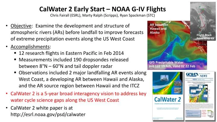
CalWater 2 Early Start – NOAA G-IV Flights Chris Fairall (ESRL), Marty Ralph (Scripps), Ryan Spackman (STC). Objective : Examine the development and structure of atmospheric rivers (ARs) before landfall to improve forecasts of extreme precipitation events along the US West Coast

E N D
CalWater 2 Early Start – NOAA G-IV Flights Chris Fairall (ESRL), Marty Ralph (Scripps), Ryan Spackman (STC) • Objective: Examine the development and structure of atmospheric rivers (ARs) before landfall to improve forecasts of extreme precipitation events along the US West Coast • Accomplishments: • 12 research flights in Eastern Pacific in Feb 2014 • Measurements included 190 dropsondes released between 8°N – 60°N and tail doppler radar • Observations included 2 major landfalling AR events along West Coast, a developing AR between Hawaii and Alaska, and the AR source region between Hawaii and the ITCZ • CalWater 2 is a 5-year broad interagency vision to address key water cycle science gaps along the US West Coast • CalWater 2 white paper is at http://esrl.noaa.gov/psd/calwater AR between Hawaii and Alaska Flight Track from HI to AK GFS Precipitable Water Init 12Z 19 Feb, Valid 0Z 22 Feb
Forecast Improvements? – CrISand ATMS Flight Plan, 8 Feb 2014 AR Mesoscale Frontal Wave • Item 1: AR landfalling forecast errors are large (500 km at 5 days, 200 km at 1 day from Wick et al. 2013) • ➤ Preliminary analysis suggests retrievals from CrIS and ATMS could improve landfalling forecasts Dropsondes GFSIntegrated Vapor Transport Init 6Z 8 Feb, Valid 21Z 8 Feb AR Developing on 21 Feb • Item 2: Vertical structure of water vapor in ARs is crucial to getting integrated vapor transport correct • ➤ Numerous discrepancies between model and dropsonde data were observed in vertical profiles of water vapor across ARs