Download
1 / 4
40 likes | 169 Vues
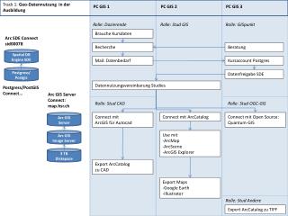
Track 1: Geo-Datennutzung in der Ausbildung. PC GIS 1. PC GIS 2. PC GIS 3. Rolle: Dozierende. Rolle: Stud GIS. Rolle: GISpunkt. Brauche Kursdaten. Arc SDE Connect sid00078. Beratung. Recherche. Spatial DB Engine SDE. Mail: Datenbedarf. Kursaccount Postgres. Postgress/

E N D
Track 1: Geo-Datennutzung in der Ausbildung PC GIS 1 PC GIS 2 PC GIS 3 Rolle: Dozierende Rolle: Stud GIS Rolle: GISpunkt Brauche Kursdaten Arc SDE Connect sid00078 Beratung Recherche Spatial DB Engine SDE Mail: Datenbedarf KursaccountPostgres Postgress/ Postgis Datenfreigabe SDE Datennutzungsvereinbarung Studies Postgress/PostGIS Connect… Arc GIS Server Connect: map.hsr.ch Rolle: Stud CAD Rolle: Stud OGC-GIS Arc GISServer Connect mit ArcGIS für Autocad Connect mit ArcCatalog Connect mit Open Source: Quantum-GIS Arc GISImage Server • Use mit • ArcMap • ArcScene • ArcGIS Explorer 3 TB Diskspace Export ArcCatalog zu CAD • Export Maps • Google Earth • Illustrator Rolle: Stud Andere Export ArcCatalog zu TIFF
Track 2: Mobile Datenerfassung ‚Landschaftsmonitoring‘ PC GIS 1 PC GIS 2 PC GIS 3 Rolle: GPS-Kartierer Rolle: Mobile Internet Rolle: Analyst Büro GeoDB: SDE Vorbereitung GPS:Checkout ArcGIS Erst-Erfassung Gelände Zurückspielen Datenbank ArcPad Webbasierte Editierung auf Tablet PC Browser / WebOffice ArcGIS Erfassung im Büro Sicht auf Bürodaten Internet Webserver Sicht auf Felddaten WebOffice Geoprocessing Felddaten ArcGIS Server Sicht Analyse Resultate Serverpublikation Sicht Analyseresultate GPS-Sicht Analyseresultate
Track 3: Kartenservice ‚Selbstgemacht‘ PC GIS 1 PC GIS 2 PC GIS 3 Rolle: Planungsstudent: Author Rolle: GISpunkt Publisher ArcGIS Erstelle ArcMap –Karte aus Daten SDE Map.MXD Optimiere Map für Serverpublikation Mail MXD an GIS Support Map.MXD GeoDB: SDE Publiziere MXD als ArcGIS Kartenservice, KML-Networklink und OGC-WMS ArcGIS Server Prüfe Applikation, Verbreite URL‘s Internet Webserver Rolle: Adressat Browser Rolle: Adressat GoogleEarth Rolle: Adressat WMS Nutzung Browser Appl. • Nutze Google Earth Netzwerklink: • Zoom, • Move Nutze WMS in PostGIS: - Add Service - Zoom Nutze Applikation: - Zoom - Identity Google Earth WMS
Track 5: ‚Collaborative Mapping und PPGIS‘ PC GIS 1 PC GIS 2 PC GIS 3 Rolle: Planer/Moderator Rolle: Mitwirkender 1 RolleMitwirkender 2 Publiziert Grundlagen und Ideen Forum/Blog/ etc. Wiki Kommentiert Idee Zeichnet neue Idee Internet Webserver Beobachtet Plan MySQL Beobachtet Wiki Reagiert mit Antwort Browser / WebOffice Reagiert mit Wikibeitrag Internet Webserver Beobachtet eigene Wikiseite WebOffice Reagiert erneut Sieht Planeintrag und Wiki und beginnt sich zu beteiligen ArcGIS Server Aktivitätsauswertungen… GeoDB: SDE