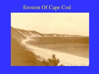
Erosion Of Cape Cod
90 likes | 354 Vues
Erosion Of Cape Cod. Formation of the Cape. Glacial till deposited on the remnance of ancient mountain range Came out of its permafrost state 12,000 years ago and has since been eroding Although littoral drift is causing some areas of the cape to grow, the cape will eventually erode away.

Erosion Of Cape Cod
E N D
Presentation Transcript
Formation of the Cape • Glacial till deposited on the remnance of ancient mountain range • Came out of its permafrost state 12,000 years ago and has since been eroding • Although littoral drift is causing some areas of the cape to grow, the cape will eventually erode away
Storms Most of the Cape’s erosion is from storm events Huge cliff line the ocean and bay so majority of sediment is lost in landslide events Two types of storms account for erosive damages 1.Hurricanes: originate in low latitudes and move inland by Mass. strong southerly winds erode the south side of the Cape 2.Northeasters: more common than hurricanes and account for more damage low moving northeast, blows winds in that direction
Deposits that replenish the Cape Three types of deposits from which Cape replenishes itself with sediment 1.Primary deposits: huge deposits of glacial till, form the huge cliffs and dunes that line the shoreline on ocean and bay 2.Secondary deposits: when waves cut into dunes and transport sediment to beaches, offshore bars, or barrier islands 3.Tertiary deposits: when sediment is distributed in the marshes behind the fordune by tides, wind or waves
Problem With Defining Erosion • Due to steep dunes erosion takes place in sudden jumps on the Cape, relative erosion rate doesn’t show this • Relative erosion rate must also be looked at over a long period of time to give a correct representation • Area between Nauset Light and Highland Light • 1850: Thoreau noted that erosion was slightly less than 6 feet a year • 1889: Henry Marindin calculated over a forty year period and found same area to be 3.2ft/yr. • 1959: John Ziegler used a seventy year study to approximate 2.6 feet a year
Annual Erosion Rates • Not reliable as a measure from year to year • Magnified by Capes steep cliffs which could erode 10 feet one year and not at all over the next twelve • Larger the time frame that it is evaluated over the better it is • Not perfect but what is needed for setback guidelines and property life approximations
The Cape’s Hard Substrate Mess • Large demand for coastal property so high stakes for land • Until 1960s hard substrate was the way to go • Structures on the Cape • -Groins: numerous groins line the bayside, interrupting littoral drift • -Jetties: used to stabilize inlets on the Cape, short enough so some littoral drift takes place around them • Major problem is the Cape Cod canal where the giant jetties are eroding the surrounding beaches • -Seawalls, bulkheads, and revetments: reflect wave activity and carry sand outward stop erosion that would replenish beaches
Solutions For the Cape Best actions are to minimize erosion through following: 1.remove or minimize damage from existing hard structures 2.educate beachgoers on the effect they have to minimize damage, limit offroad vehicles, discourage traffic though the dunes 3.construct removable walkways to get down cliffs 4.revedgetate and or sand fence damaged dune areas