実 習 1 : QGIS 、 OGR
80 likes | 317 Vues
実 習 1 : QGIS 、 OGR. 実習内 容. QGIS シェープファイルの閲覧 WMS の閲覧 GDAL/OGR ogrinfo :メタデータの閲覧 ogr2ogr :データフォーマット変換. 必要なファイル. 仙台市周辺 の 植生 図 (ポリゴン) P574026.shp, p574027.shp, p574036.shp, p574037.shp 宮城県 の河川 W05-07-04-GB02.shp (ライン) W05-07-04-GB03.shp (ポイント). QGIS :シェープファイルの閲覧.

実 習 1 : QGIS 、 OGR
E N D
Presentation Transcript
実習内容 • QGIS • シェープファイルの閲覧 • WMSの閲覧 • GDAL/OGR • ogrinfo:メタデータの閲覧 • ogr2ogr:データフォーマット変換
必要なファイル • 仙台市周辺の植生図 (ポリゴン) • P574026.shp, • p574027.shp, • p574036.shp, • p574037.shp • 宮城県の河川 • W05-07-04-GB02.shp (ライン) • W05-07-04-GB03.shp (ポイント)
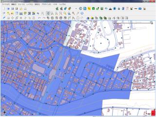
QGIS:シェープファイルの閲覧 • QGISで植生、河川のデータを開いて見る • 属性テーブルを開く • 文字化けしている場合はエンコーディングに注意 • 文字化けしている場合はファイルを開きなおす • フィーチャーの情報を見てみる(ツールに馴染む) • プロパティーからメタデータを確認する • シンボルを変えて地図を作る(わかりやすいように) • 植生ポリゴンの透明度を50%に設定する • ベースの地図としてNASAのWMSサーバーからランドサットのモザイク画像を取る • ラベルを加える
QGISでデータを加工 • 統合した植生図をQGISで表示 • 統合した植生図をエンコーディングを変えて保存 • UTF-8を指定 • 河川データをQGISで表示 • 河川データの内、植生図と重なる部分だけをエクスポート • 文字のエンコーディングをUTF-8に指定
OGR • メタデータを見てみる。投影系の確認 • Ogrinfo • 4つの植生タイルを1つに統合する • Ogr2ogr-append -update • すべてのデータの参照系をJGD2000に変換する • ogr2ogr • JGD2000 / Japan Plane Rectangular CS X • EPSG:2452 • 河辺・湿原クラス(SHOKU_C = 47)をKMLに書き出す • ogr2ogr -f -where
QGISで参照系の変換 • 世界地図を読み込む • country.shp • 設定の投影系プロパティーで投影系を指定 • EPSG:3005 • オンザフライをチェックする • ウィンドウを一度閉じて投影系が変換されたことを確認 • シェープファイルを出力 • 変換したデータを読み込む
QGISのアドイン • それでも時間が余ったら、 • アドインを試して見る • Table Manager • Ftools • ---