Download
1 / 29
290 likes | 455 Vues
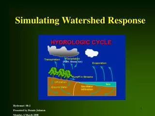
Working with TNRCC’s Watershed Delineator. by Mark Dougherty. What is Watershed Delineator?. Watershed Delineator is a set of procedures, tools, and utilities… developed by TNRCC and ESRI… to delineate watershed boundaries on a digital elevation model. Nuts and Bolts.

E N D
Working with TNRCC’s Watershed Delineator by Mark Dougherty CEE 5224 - Advanced GIS
What is Watershed Delineator? • Watershed Delineator is a set of procedures, tools, and utilities… • developed by TNRCC and ESRI… • to delineate watershed boundaries on a digital elevation model. CEE 5224 - Advanced GIS
Nuts and Bolts • Watershed Delineator is a series of algorithms… • developed in ArcView’s command language (Avenue script)… • as an “add-on” extension. • Watershed Delineator makes the modeling process more efficient because it requires no external file sharing. CEE 5224 - Advanced GIS
Nuts and Bolts (cont.) Watershed Delineator provides three major functionality areas: • Interactive delineation and data entry • Utilities • Miscellaneous functions CEE 5224 - Advanced GIS
Interactive delineation and data entry Point Delineation Segment Delineation Batch Point Definition Batch Polygon Definition Batch DelineationBatch Point Delineation Batch Segment Delineation Batch Polygon Delineation CEE 5224 - Advanced GIS
Utilities GRID Preprocessing Vector Preprocessing Tag Operations CEE 5224 - Advanced GIS
Miscellaneous functions Merge Selected Polygons Subtract Selected Polygons DEM Extraction Flow Tracing No-preprocessing Watershed Delineation Display of Table Structures CEE 5224 - Advanced GIS
1. Find a copy of WshdDel.avx script. Script is available on ESRI’s Water Resources CD (1999). Script was not found on either the ESRI or the CRWR websites. How do I get started with Watershed Delineator? CEE 5224 - Advanced GIS
2. Copy .avx file to EXT32. CEE 5224 - Advanced GIS
3. Load two file extensions. CEE 5224 - Advanced GIS
Watershed Delineator interface CEE 5224 - Advanced GIS
Hydro pull-down menus Grid preprocessing Vector preprocessing CEE 5224 - Advanced GIS
Delineation Files Fill Sinks Flow Direction Flow Accumulation Stream Definition Stream Segmentation Watershed Subdelineation Line GRID to Shape Poly GRID to Shape Dissolve Streamless Polygons Define Table Structures Stream Segment Processing Identify Head Sections Create Aggregated Subwatersheds CEE 5224 - Advanced GIS
Delineation Files sets up themes used in the delineation process Reference to the appropriate data set is achieved through use of theme tags . CEE 5224 - Advanced GIS
Batch Processing: Delineate on Segments Delineate on Polygons Delineate on Points Extract GRID by Delineate on pt. Polygon (no preproc.) Rectangle Trace flow path Circle Subtract polygns Calculate flow length and Tc [not shown] Add an Outlet Point Delineate on a Segment Delineate on a Point CEE 5224 - Advanced GIS
How does Delineator work? CEE 5224 - Advanced GIS
Source: Watershed Delineator documentation CEE 5224 - Advanced GIS
What does the display look like? CEE 5224 - Advanced GIS
Other delineation tools • A new Avenue script is available on the ESRI site: CEE 5224 - Advanced GIS
Other resources from ESRI • Search ESRI’s Web Site for keyword “Watershed Delineator” • You will get the following titles: CEE 5224 - Advanced GIS
Questions? CEE 5224 - Advanced GIS