
Uploaded by
zihna
1 SLIDES
143 VUES
10LIKES
ASAP Cloud Top Pressure Validation
DESCRIPTION
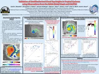
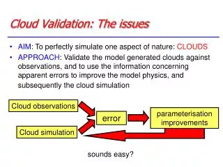
This study focuses on the validation of cloud top height measurements obtained from the GOES-12 Imager and Sounder instruments. The heights derived from these instruments are compared against Cloud Phase Lidar measurements collected during the Atlantic THORPEX Regional Campaign (ATReC). The assessment aims to enhance the accuracy and reliability of satellite-derived cloud top height data, providing crucial insights for meteorological research and improving weather forecasting models.
Download

1 / 1
Télécharger la présentation 
ASAP Cloud Top Pressure Validation
An Image/Link below is provided (as is) to download presentation
Download Policy: Content on the Website is provided to you AS IS for your information and personal use and may not be sold / licensed / shared on other websites without getting consent from its author.
Content is provided to you AS IS for your information and personal use only.
Download presentation by click this link.
While downloading, if for some reason you are not able to download a presentation, the publisher may have deleted the file from their server.
During download, if you can't get a presentation, the file might be deleted by the publisher.
E N D
Presentation Transcript
ASAP Cloud Top Pressure Validation Validation of GOES-12 Imager and Sounder cloud top height. Heights are compared to Cloud Phase Lidar measurements from ATReC (Atlantic THORPEX Regional Campaign).


More Related