LEO
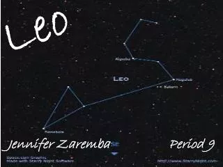
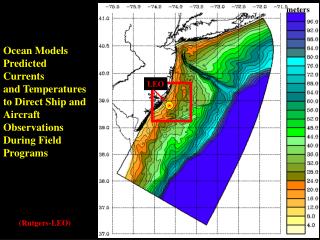
LEO. meters. Ocean Models Predicted Currents and Temperatures to Direct Ship and Aircraft Observations During Field Programs. (Rutgers-LEO). Surface Temperature in o C (colors) and Winds(arrows). Tuckerton, NJ. Models Predict Cold Water Upwelling During Southwest Winds.

LEO
E N D
Presentation Transcript
LEO meters Ocean Models Predicted Currents and Temperatures to Direct Ship and Aircraft Observations During Field Programs (Rutgers-LEO)
Surface Temperature in oC (colors) and Winds(arrows) Tuckerton, NJ Models Predict Cold Water Upwelling During Southwest Winds Warm Water Moves on Shore During Downwelling (Rutgers-LEO)
Cross Section of Upwelling Event (Temperature in oC) Models Predict Cold Water Upwelling During Southwest Winds Warm Water Moves on Shore During Downwelling (Rutgers-LEO)
Surface and Sub-Surface Floats Models Predict Particles in Water Travel Northward during Upwelling Events and Southward During Downwelling Events (Rutgers-LEO)
Ocean Temperatures and Currents Fluctuate on the New Jersey Coast in Response to Changing Winds Green Arrows are Wind Red Surface is 18oC(65oF) Blue Surface is 13oC(54oF) (Rutgers-LEO)
The Hudson River • The Gulf of Maine • Martha's Vineyard/Nantucket These Models are Also Being Used to Predict Currents,Temperature, and Salinity in:
Hudson River Estuary 30 -5 25 -10 20 Salinity (PSS) Depth (m) -15 15 -20 10 -25 5 25 5 15 20 10 Distance (km) (USGS&WHOI)
Gulf of Maine Tides (Colors are Sea Level Height) Surface Elevation (m) & Currents (USGS)
Tidal Currents Around Martha's Vineyard and Nantucket Temperature (color) & Currents (arrows) (Rutgers)
Temperature (color) & Currents (arrows) New Jersey Coast and Mid-Atlantic Bight Waters are Influenced by the Gulf Stream and Southward Cold Water Currents from Canada (Rutgers)
(Colors Show Sea Temperatures oC at 100m below the Surface) Currents Along the East Coast of North America are Also affected by the Entire Atlantic Ocean (Rutgers)
(Colors Show Sea Temperatures oC at 100m below the Surface) Currents Along the East Coast of North America are Also affected by the Entire Atlantic Ocean (Rutgers)
Our Models are Used in Oceanographic Studies in over 30 Countries by: • Universities • Government Agencies • Companies Totaling 280 Registered Users on Six Continents (Relief Image from NOAA Animation by Rutgers)
The Laboratory • To Rivers • To Harbors and Bays • To Continental Shelves • To the Global Ocean Our Models are Used to Predict Ocean Processes and/or Variability on Scales from:
The Laboratory • To Rivers • To Harbors and Bays • To Continental Shelves • To the Global Ocean Our Models are Used to Predict Ocean Processes and/or Variability on Scales from:
Simulation of Costal Upwelling and Downwelling at Subsurface Canyon Rotating Tank at Coriolis Lab, Grenoble 13m in Diameter Colors Show the Density of Water Just Above the Shelf Break (Grey is the Base Density) Lab Experiments Try to Emulate Coastal Processes
Currents are Vital to the Transport of Floats Such as Fish Larvae (PMEL/NOAA)
Modeling California Current System ROMS Model SST Satellite Observation 100 km Very energetic Mesoscale variability (UCLA)
Hernan’s Comments here: (Rutgers)
The Simulations You Have Just Seen have been Run at Various Super Computer Centers Around the World. Simulation Performed by Rutgers IMCS have been run at Super Computer Centers at: • The US Naval Research Lab • NASA Stennis Space Center • NASA Ames Research Center • Arctic Region Supercomputing Center • Among Others The Simulation of the North Atlantic Ocean, For Example, has 2.5x10⁸ Unknown Variables and takes 153 Days on 32 Processors of an SGI Origin 3000 Supercomputer to Obtain 7 Years of Simulation.